geo.wikisort.org - Island
San Pietro Island (Italian: Isola di San Pietro, Ligurian Tabarchino: Uiza de San Pé, Sardinian: Isula 'e Sàntu Pèdru) is an island approximately 7 kilometres (4 miles) off the South western Coast of Sardinia, Italy, facing the Sulcis peninsula. With 51 square kilometres (19.7 sq mi) it is the sixth largest island of Italy by area. The approximately 6,000 inhabitants are mostly concentrated in the fishing town of Carloforte, the only comune in the island. It is included in the province of South Sardinia. It is named after Saint Peter.
This article needs additional citations for verification. (September 2013) |


The island is connected by regular ferry service to Portovesme and Calasetta.
Geography
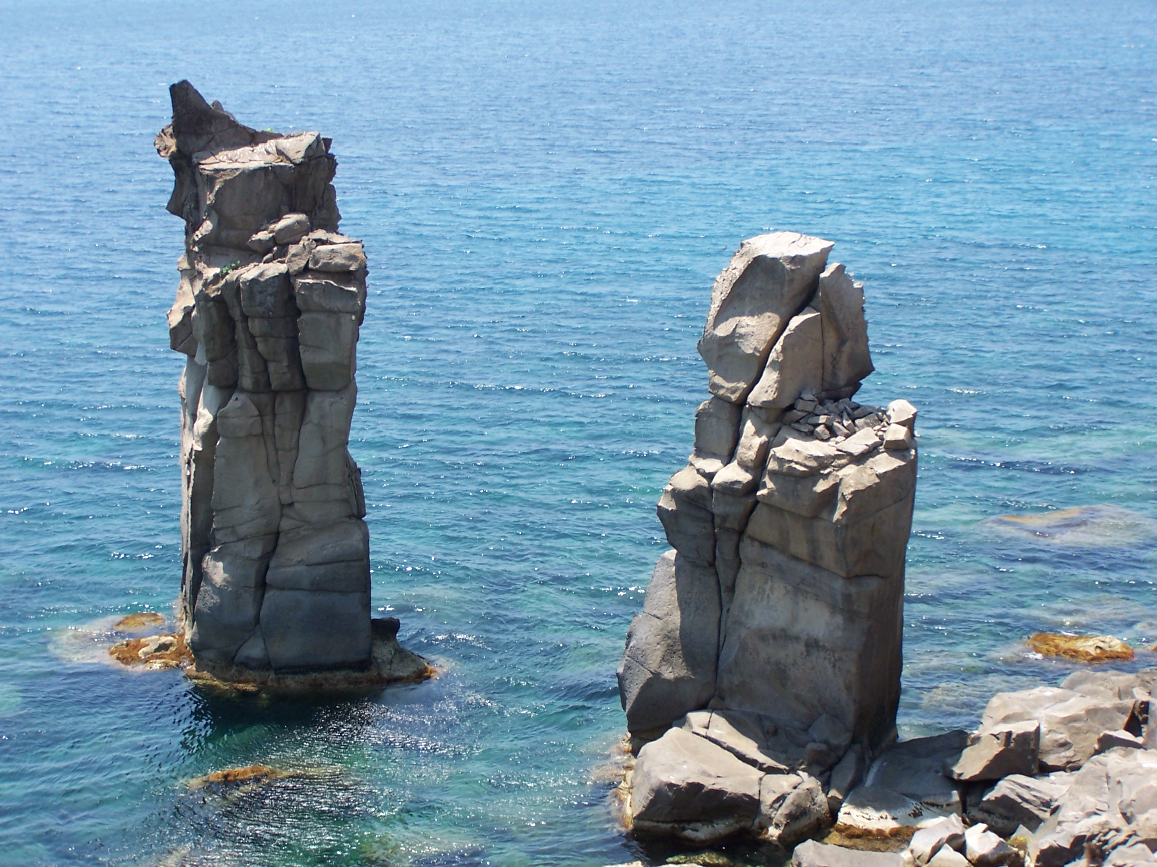
The island is of volcanic origin. The rocks are of Cenozoic age, and include basalt, dacite and rhyolite (including the peralkaline variety comendite).[1] The 18 km (11 mi) of its coasts are mostly rocky; the western and northern part includes some natural grottoes, unprotected landings, with a few small beaches, in general here the coast is usually very steep, rocky. The eastern coast, on which the port of Carloforte lies, is more protected low and sandy.

Off the north-western coast are two small islands, the Isola dei Ratti and Isola Piana. The latter includes the remains of one of the largest tonnara in Italy, now turned into a tourist resort.
The island has no rivers or streams, but features numerous ponds and marshes. The interior is hilly, the highest points being the Bricco (hill) Guardia dei Mori (211 m (692 ft)) and Bricco Tortoriso (208 m (682 ft)).
The vegetation is that typical of the Mediterranean coast, with Cistus, mastic, strawberry tree, juniper, Aleppo pine and holm oak. Here groves of oak and pine with clearings that are often cultivated, and populated with scattered houses. Cultivation, held especially in the eastern and more protected region, includes grape (Vitis vinifera), fig and Indian fig. The western part exposed to the prevailing wind, the mistral, is more arid, with low scrub vegetation and largely uninhabited. The climate is temperate-hot. The island is connected to Sardinia and to the next island of Sant'Antioco by two ferry lines.
History

The island has been known since ancient times. The Phoenicians called it Enosim or Inosim, which means "island of Accipiters".[2] while for the Greek it was Hieracon Nesos and for the Romans Accipitrum Insula (Sparrowhawk Island). The latter is derived from the presence of the small Eleonora's falcon, which is still present on the island. San Pietro is home today to remains from the Phoenician, Roman and Sardinian civilizations.
According to a legend, the island is so named because St. Peter visited the island in 46 AD.
In 1739 century the then-uninhabited San Pietro was colonized by people of Ligurian language and ethnicity. They had fled the Republic of Genoa's colony on the small Tunisian island of Tabarka, established in 1542 for the purpose of coral fishing, after it had been taken over by the Bey of Tunisia. Today most of the population has retained a variant of the Genoese dialect, called Tabarchino, which is also spoken in Calasetta, in the northern part of the neighboring Sant'Antioco island, whose residents are of the same origin. The island is twinned with the Spanish island of Tabarca, which was likewise settled by former residents of the Tabarkan colony.
The town of Carloforte (Fort Charles) on the Island of San Pietro was dedicated to Charles Emmanuel III of Sardinia, who had granted the island to the Tabarkan refugees.
See also
- List of islands of Italy
- Genoese-Tabarka diaspora
Bibliography
- Simone Baldo, The new continent. San Pietro island. Sardinia., 2015, Private Edition
References
- Cioni, R.; Funedda, A. (2005). Manga, M.; Ventura, G. (eds.). "Structural geology of crystal-rich, silicic lava flows: A case study from San Pietro Island (Sardinia, Italy)". Kinematics and Dynamics of Lava Flows. Special Paper 396. Geological Society of America: 1–14.
- Slouschz, Nahoum (1942). Thesaurus of Phoenician Inscriptions (in Hebrew). Dvir. pp. 132–133.
Islands of Italy in the Mediterranean | ||
|---|---|---|
| ||
Authority control | |
|---|---|
| General |
|
| National libraries | |
| Other |
|
На других языках
[de] San Pietro (Insel)
San Pietro (italienisch Isola di San Pietro, sard. Isula ’e Sàntu Pèdru) ist eine rund 54 km² große Insel vor der Südwestspitze Sardiniens.[1] Das sieben Kilometer von Sardinien entfernte Eiland gehört zur Provinz Sud Sardegna. Die 6095 Einwohner von San Pietro (Stand 31. Dezember 2019) wohnen zu über 90 Prozent in der Inselhauptstadt Carloforte. Die übrigen leben in Streusiedlungen.- [en] San Pietro Island
[es] Isla de San Pietro
La isla de San Pietro (en italiano: Isola di San Pietro) es una isla de aproximadamente 7 km de la costa sur occidental de Cerdeña, Italia, frente a la península de Sulcis. Se incluye en la provincia de Cerdeña del Sur.[fr] Île San Pietro
L'île San Pietro est l'une des deux îles principales de l'archipel des Sulcis, situé au large de la péninsule de Sulcis, dans la province de Sardaigne du Sud, dans la partie sud-ouest de la Sardaigne. Elle couvre une superficie de 51 km2 (sixième île italienne) et a une population d'environ 6 500 habitants, principalement concentrés dans la localité de Carloforte, unique centre urbain de l'île.[it] Isola di San Pietro
L'isola di San Pietro (in tabarchino Uiza de San Pé, in sardo isula 'e Sàntu Pèdru), è una delle due isole principali dell'arcipelago del Sulcis, situata al largo della penisola del Sulcis nella parte sud-occidentale della Sardegna. Ha un'estensione di 51 km² (sesta isola italiana) e circa 6 100 abitanti prevalentemente concentrati nella località di Carloforte, unico centro abitato dell'isola.[ru] Сан-Пьетро (остров)
Сан-Пье́тро (итал. Isola di San Pietro) — остров в Средиземном море. Территория Италии. Входит в состав коммуны Карлофорте провинции Карбония-Иглезиас (область Сардиния). Площадь — 51 км². Население — 6488 (2004).Другой контент может иметь иную лицензию. Перед использованием материалов сайта WikiSort.org внимательно изучите правила лицензирования конкретных элементов наполнения сайта.
WikiSort.org - проект по пересортировке и дополнению контента Википедии