geo.wikisort.org - Island
Caprera is an island in the Maddalena archipelago off the coast of Sardinia, Italy.[1] In the area of La Maddalena island in the Strait of Bonifacio, it is a tourist destination and the place to which Giuseppe Garibaldi retired from 1854 until his death in 1882.[1] Scarcely populated, the majority of the inhabitants live in Borgo di Stagnali. The island of Caprera is entirely included in the La Maddalena Archipelago National Park: a marine and land protected area of national and community interest. In particular, the marine zone in front of the area of Punta Rossa, a southern extension of the island, is an area with maximum environmental protection, with Cala Andreani and Spiaggia del Relitto. The eastern ridge of the island is a land zone of full protection, while the marine area in front of Punta Coticcio, including Cala Coticcio, is protected by the managing authority of the National Park.
 Cala Napoletana on the northwest shore of Caprera | |
 Caprera | |
| Geography | |
|---|---|
| Location | Strait of Bonifacio |
| Coordinates | - 41°12′26″N 9°27′40″E |
| Archipelago | Maddalena archipelago |
| Area | 15.7 km2 (6.1 sq mi) |
| Highest elevation | 212 m (696 ft) |
| Highest point | Monte Tejalone |
| Administration | |
Italy | |
| Region | Sardinia |
| Province | Olbia-Tempio |
Features
The island was probably given its name because of the numerous wild goats living on it (capra means "goat" in Italian). It is the second largest island in the archipelago and has an area of 15.7 km2 (6.1 sq mi) and 45 km (28 mi) of coastline. Monte Tejalone is the highest point (212 m). On the south-western side is a sailing centre and the many coves and anchorages along the coastline make the landing easy. This island has been declared a natural reserve for the resident seabirds, the royal seagull, cormorant and peregrine falcon. Caprera is linked to La Maddalena island by a 600-metre (2,000 ft) causeway.
Giuseppe Garibaldi
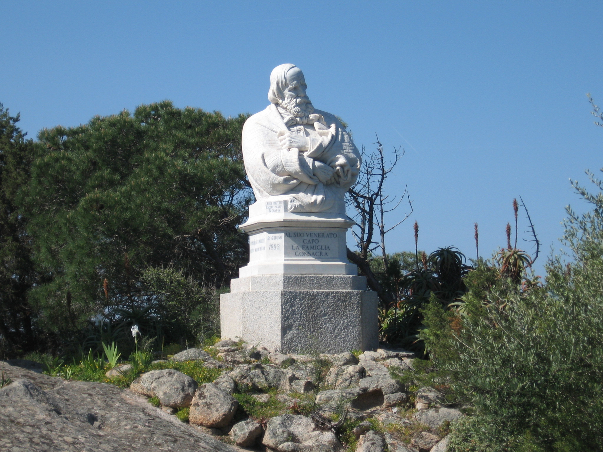

The island is associated with Giuseppe Garibaldi, an Italian patriot and fighter who lived in the 19th century and was one of the fathers of Italian unification. He bought about half of the island in 1855 and died there in 1882. His house is now a museum and a memorial chapel, and the island is a national monument.
History

After the Roman occupation, Caprera remained deserted for centuries before being inhabited by groups of shepherds at the beginning of the 19th century. In the second half of the same century, an English family settled there, the Collins, owners of some lands on the island. Many remains of Roman cargo ships have been found here. In 1855, Garibaldi decided to settle there and planted the first trees of the blooming pinewood which covers the island today. A century after Garibaldi's death, the island was freed from military restrictions and is completely open to the public.
The island is known especially for having been Giuseppe Garibaldi’s last abode for over 20 years and the place of his death. Indeed, with the inheritance of his brother Felix, he acquired the northern half of Caprera in 1856, having initially lived in a hut.
A few years later, the famous Casa Bianca was built in accordance with Garibaldi’s will, in the South American fazenda style, nowadays a museum; some years after, funds raised by his sons and fans allowed him to buy also the other half of the island, which until then had belonged to the English spouses Richard and Emma Collins.
In the big estate, Piana della Tola, Garibaldi planted a lot of trees and started living the life of a farmer, cultivating fields and breeding chickens, sheep, horses (his famous white mare Marsala is buried not far from the house) and a lot of donkeys, to whom he gave his enemies’ names out of amusement. The most unruly of them was called after Pope Pius IX.
Inside the Casa Bianca, Garibaldi lived with the sons that he had with Anita, the ones he had with a servant and the ones he had with his third wife, Francesca Armosino.
In Garibaldi’s room, the clock and the calendars, which are hanging on a wall, still mark the date and time of his death: 2 June 1882 at 6.21 pm. Despite his last wishes, his remains were embalmed and buried in a grave (made of rough granite) just behind the house.
His house, boats and objects, which have become relics of one of the best known and visited museums in Italy, have remained in Caprera. The Garibaldi Compendium of Caprera is open for visit, except for weekly closure on Mondays. Garibaldi’s life on the island and how he cultivated it are described in the memoir written by his daughter Clelia, entitled Mio Padre.
In 1982, Caprera was declared an Oriented Nature Reserve, until the establishment of the National Park.
Sailing
Caprera's Porto Palma gulf is home to the Centro Velico Caprera school since 1967.
See also
References
- . Encyclopædia Britannica. Vol. 05 (11th ed.). 1911. p. 290.
External links
- Sito web istituzionale del Parco Nazionale dell'Arcipelago La Maddalena
- Mio Padre, ricordi di Clelia Garibaldi
Authority control | |
|---|---|
| General | |
| National libraries | |
На других языках
[de] Caprera
Caprera ist eine Insel der Inselgruppe La Maddalena vor der Küste Sardiniens. Sie ist Teil der Gemeinde La Maddalena in der Straße von Bonifacio zwischen Sardinien und Korsika. Sie ist heute ein Tourismusziel und war der Ort, an dem Giuseppe Garibaldi von 1854 bis zu seinem Tod 1882 lebte.[1]- [en] Caprera
[es] Caprera
Caprera (en sardo Caprèra) es una isla situada al noreste de Cerdeña (Italia), en el archipiélago de la Magdalena que comprende unos 16 km²; y reúne una población de 170 habitantes. En esta isla se encuentra la casa y la tumba de Garibaldi. Pertenece al municipio de La Maddalena. La cima más alta, Monte Teialone alcanza los 212 msnm. La isla es la segunda por extensión después de la de Maddalena y está unida a ella por un puente. Junto con las otras islas del archipiélago constituye un parque protegido y son pocos los habitantes que residen allí, principalmente en la fracción de Stagnali.[fr] Caprera
L'île de Caprera fait partie de l'archipel de La Maddalena, appartenant à la commune de La Maddalena, situé près de la côte nord-orientale de la Sardaigne. Son point culminant est le Monte Teialone qui atteint les 212 mètres au-dessus de la surface de la mer. D'une superficie de 15,7 km2, elle est la seconde île de l'archipel après celle de La Madeleine à laquelle elle est reliée par un pont. Tout comme les autres îles de l'archipel, Caprera fait partie du Parc national de l'archipel de La Maddalena, constituant ainsi un parc naturel extrêmement protégé, où peu d'habitants vivent à plein temps.[it] Caprera
L'isola di Caprera fa parte dell'arcipelago di La Maddalena, appartenente al comune di La Maddalena nella costa nord-orientale della Sardegna. Scarsamente popolata, la maggior parte degli abitanti risiede nel Borgo di Stagnali. L'isola di Caprera è interamente compresa nel parco nazionale dell'Arcipelago di La Maddalena, un'area protetta marina e terrestre di interesse nazionale e comunitario. In particolare la zona marina di fronte all'area di Punta Rossa, estrema propaggine a sud dell'isola, è un'area a massima tutela ambientale, con cala Andreani e la spiaggia del Relitto. La dorsale orientale dell'isola è zona terrestre a protezione integrale, mentre l'area marina antistante Punta Coticcio, compresa Cala Coticcio, è protetta con provvedimenti dell'ente gestore del parco nazionale. Significativa è la presenza di numerosi endemismi in tutta l'isola.[ru] Капрера
Капрера (Caprera) — остров в составе архипелага Ла-Маддалена, административно относящегося к муниципалитету Ла-Маддалена на северо-востоке Сардинии. Остров Капрера целиком относится к национальному парку архипелага Ла-Маддалена, его территория и акватория входят в охраняемую зону.Другой контент может иметь иную лицензию. Перед использованием материалов сайта WikiSort.org внимательно изучите правила лицензирования конкретных элементов наполнения сайта.
WikiSort.org - проект по пересортировке и дополнению контента Википедии