geo.wikisort.org - Mountains
Korab (Albanian: Mali i Korabit, Macedonian: Кораб) is a mountain range in the eastern corner of Albania and the western part of North Macedonia, running along the border between both countries. It forms also the European Green Belt. In Albania, it is also called Vargu lindor (English: Eastern range), but this term encompasses mountains further north, such as the Koritnik and Gjallica. The highest peak is Mount Korab at 2,751 m (9,026 ft) above sea level.[1] With a prominence of 2,169 m (7,116 ft), Korab is the 18th most prominent mountain peak in the European continent.[2] The mountains are composed of sedimentary rock, including shale, sandstone, dolomite and limestone. The name refers to a Paleochristian sea god.
| Korab | |
|---|---|
 Mount Korab | |
| Highest point | |
| Peak | Mount Korab |
| Elevation | 2,751 m (9,026 ft) |
| Prominence | 2,169 m (7,116 ft) |
| Coordinates | 41°47′25″N 20°32′48″E |
| Geography | |
 Korab Location on the Balkan peninsula | |
| Countries | Albania and North Macedonia |
| Geology | |
| Age of rock | Paleozoic |
| Mountain type | Range |
| Type of rock | Limestone |
Geographically, the Korab mountain range extends 40 km (25 mi) from the Dibër Valley in a north-south direction, between the river valleys of the Black Drin and its tributary the Radika. It is located near the tripoint of Albania, North Macedonia, and Kosovo, southwest of the Šar Mountains. The Drin Valley lies around 400 m (1,300 ft) to the west, the bed of the Radika at about 1,000 m (3,300 ft) above sea level.
The geology of the park is dominated by mountains made up of exposed faulted sedimentary rock and valleys containing glacial lakes.
The Albanian part has numerous high peaks and ranges, almost as tall as the Korab massif. To the north of this double-peak there are many other nameless peaks of a similar height. Korab-Pforte (Albanian: Maja Portat e Korabit, Macedonian: Mala Korapska Vrata) lies around 2 km (1.2 mi) southwest of Korab massif and is almost as tall as the main mountain, at 2,727 m (8,947 ft). A few hundred meters further south, there are another peaks, Maja e Moravës 2,718 m (8,917 ft) and Mali i Gramës 2,345 m (7,694 ft). The mountains are composed of shale and limestone. Much of the range is protected by nature parks; the Korab-Koritnik Nature Park.[3][4]
South of the complex of peaks around Mount Korab, there are other large mountains: Mali i Gramës (2,345 m (7,694 ft)) and Dešat's Velivar summit (2,375 m (7,792 ft)). After that, the range falls away to the city of Debar and the Debar Lake.[5] The city of Peshkopi is to the southwest of Mali i Gramës and has geothermal baths.
Image gallery
 Mali Korab and Korabska Vrata captured from Mount Korab
 The range from the Macedonian side
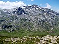 Fusha e Korabit
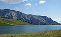 Glacial Gramë Lake
 Dešat
Dešat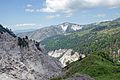 Gypsum near the Mali i Bardhë


See also
- Geography of Albania
- Geography of North Macedonia
References
- "2007 Trip Report".
- "EUROPE ULTRA-PROMINENCES 99 Peaks with Prominence of 1,500 meters or greater". peaklist.org.
- "RRJETI I ZONAVE TË MBROJTURA NË SHQIPËRI" (PDF). mjedisi.gov.al (in Albanian). p. 2. Archived from the original (PDF) on 2017-09-05. Retrieved 2017-09-05.
- "Korab - Koritnik Natural Park Management Plan" (PDF). researchgate.net. July 2014. p. 9.
- Perikli Qiriazi (2006). Gjeografia fizike e Shqipërisë. Tirana: Shtëpia botuese e librit universitar. p. 189. ISBN 99927-0-397-0.
| |||||||||||||||||||||||||||||||||||||||||||||||||||||||||||||||||||||||||||||||||||||||||||||||||||||||||||||||||||||||||||||||||||||||||||||


Authority control | |
|---|---|
| General |
|
| National libraries | |
На других языках
[de] Korabgebirge
Das Korabgebirge (albanisch Mali i Korabit, mazedonisch Кораб .mw-parser-output .Latn{font-family:"Akzidenz Grotesk","Arial","Avant Garde Gothic","Calibri","Futura","Geneva","Gill Sans","Helvetica","Lucida Grande","Lucida Sans Unicode","Lucida Grande","Stone Sans","Tahoma","Trebuchet","Univers","Verdana"}/ Korab) ist ein Gebirge im albanisch-nordmazedonischen Grenzgebiet. Die höchste Erhebung ist der Berg Korab, mit 2764 m ü. A. die höchste Erhebung der beiden Länder. In Albanien findet sich auch die Bezeichnung Vargu Lindor (deutsch Ostkette), womit aber meist auch Berge weiter nördlich bezeichnet werden wie der Koritnik und die Gjallica e Lumës.- [en] Korab
Другой контент может иметь иную лицензию. Перед использованием материалов сайта WikiSort.org внимательно изучите правила лицензирования конкретных элементов наполнения сайта.
WikiSort.org - проект по пересортировке и дополнению контента Википедии