geo.wikisort.org - Reservoir
Albania is home to 247 natural lakes and more than 800 artificial lakes. The natural lakes, most of karstic or glacial origin,[1] based on their origin, are classified as the following, 4 tectonic, 134 ice-dammed, 94 karst and 15 river. Lagoons are present along the coastal region. They occupy an area of 150 km2 (58 sq mi).[2]
List of natural lakes
Biosphere Reserve or part of a Biosphere Reserve
National Park or part of a National Park
| Name | Image | Description | Location |
|---|---|---|---|
| Lake Shkodër Liqeni i Shkodrës | The ancient Lake Shkodër, named after the city of Shkodër, is the largest lake in Southern Europe.[3] The climate is mediterranean climate (Csa), defined under Köppen climate classification. Geographically, it is located on the border between Albania and Montenegro. Lake Shkodër covers an area that seasonally fluctuates between 370 km2 (140 sq mi) to 600 km2 (230 sq mi).[4] The maximum depth of the lake is 44 m (144 ft). However, only one third 142 km2 (55 sq mi) belongs to Albania. |  | |
| Lake Ohrid Liqeni i Ohrit |  | Lake Ohrid is the deepest lake 288 m (945 ft) in the Balkans, the oldest lake in Europe and one of the oldest in the world.[5][6] It straddles the mountainous border between eastern Albania and southwestern North Macedonia. Almost 110 km2 (42 sq mi) belongs to Albania; the water leaves Lake Ohrid through its only outlet, the Black Drin river flowing in a northerly direction into Albania and thus to the Adriatic sea. It features unique and varied biodiversity, hosting more than 200 endemic species.[7] The cities located at the lakeside are Pogradec in Albania, and Ohrid and Struga in North Macedonia. In addition, the Ohrid-Prespa Transboundary Reserve was added to UNESCO's World Network of Biosphere Reserves. | |
| Lake Prespa Liqeni i Prespës | 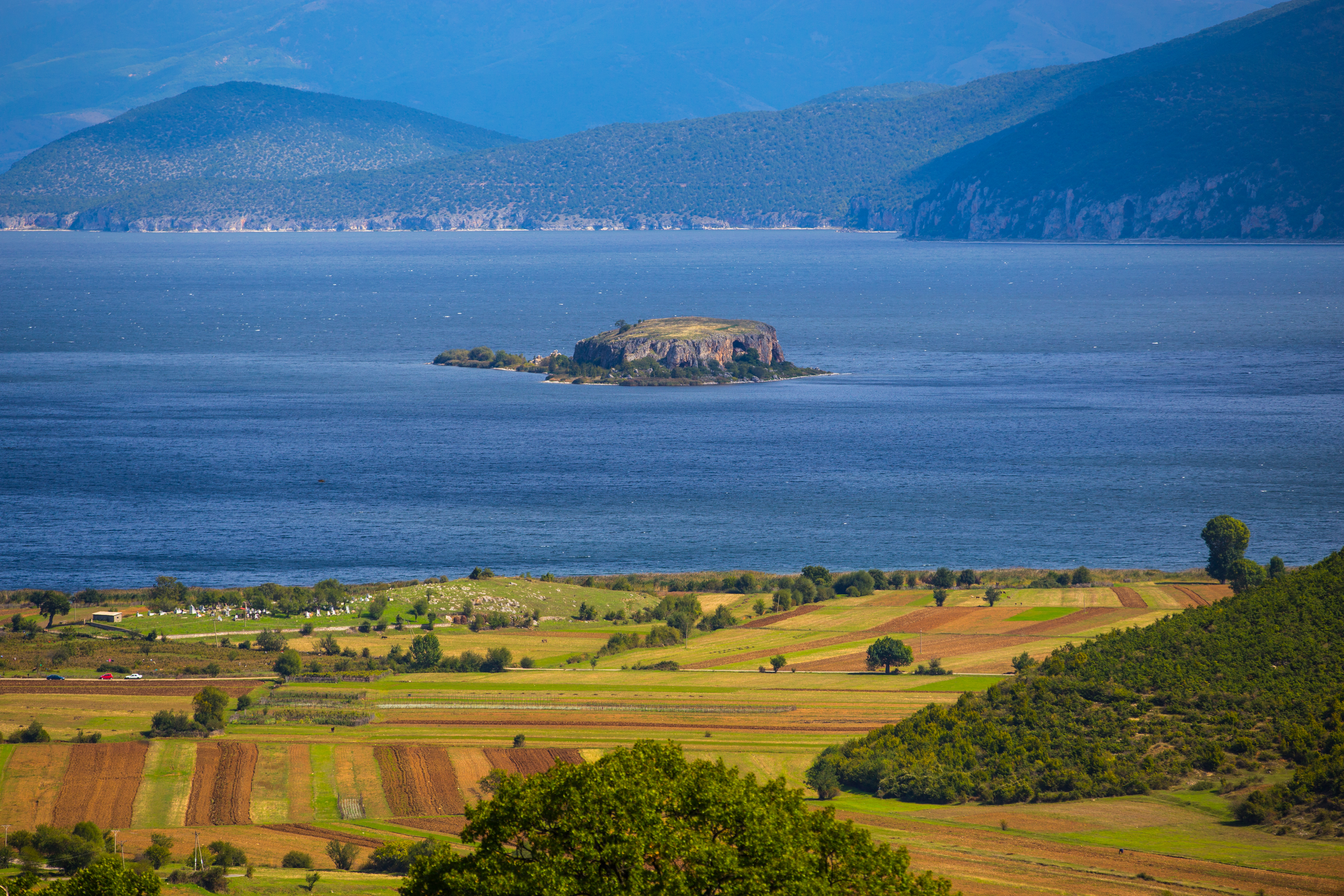 | Lake Prespa is located in southeast Albania, at the border triangle with Greece and North Macedonia. Having a surface area of 176.3 km2 (68.07 sq mi), only 46.3 km2 (17.88 sq mi) belongs to Albania. The Prespa National Park was declared on 18 February 1999, that encompasses the entire Albanian part of Prespa. The national park is characterized by its high vegetation and biodiversity.[8] There are approximately 1130 species of vascular plants and 174 fungus. | |
| Small Prespa Lake Liqeni i Prespës së Vogël |  | Small Prespa Lake is located in southeast Albania, at the border with Greece, with a surface area of 45.39 km2 (17.53 sq mi) and only 4.3 km2 (1.66 sq mi) belongs to Albania. It is known for hosting the largest breeding colony of the Dalmatian pelican in the world. Its surface is 853 m (2,799 ft) above sea level. The maximum depth of the lake is 7.7 m (25 ft). | |
| Lake Butrint Liqeni i Butrintit | Lake Butrint, named after the ancient city of Butrint, is a lagoon and is located near the city of Sarandë, southern Albania. It overlooks the Ionian sea. The lake has a length of 7.1 km (4.4 mi) and a width of 3.3 km (2.1 mi), with a surface area of 16.3 km2 (6.29 sq mi). The maximum depth of the lake is 21 m (69 ft). The lake is also part of the Butrint National Park. Because of its climatic, hydrological and geological conditions, the lake is marked by its high vegetation and biodiversity. The fauna is represented by 39 species of mammals, 246 species of birds, 25 species of reptiles, 10 species of amphibia and 105 species of fish. | |
Other smaller natural or glacial lakes include Lura Lakes, Lake Sheep, Lake Gistova, Lake Gramë, Lake Buni Jezercë, Lake Dash, Lake Sylbicë, Lake Dhënve, Lake Sope and Lake Malik, which was drained by government's decision.
List of artificial lakes
Nature Park or part of a Nature Park
Nature Reserve or part of a Nature Reserve
| Name | Image | Description | Location |
|---|---|---|---|
| Lake Fierza Liqeni i Fierzës | Lake Fierza has a surface area of 72.6 km2 (28.03 sq mi) with a maximum depth of 128 m (420 ft) and a volume of 2.7 billion cubic meters of water.[9] It is located on the Drin river near Kukës, northern Albania, stretching across the border to Kosovo in the White Drin Valley. The reservoir was formed as a result of the construction of the Fierza Hydroelectric Power Station in 1978. Fierza serves as a regulator of the water supply for both Lake Vau-Dejës and Koman. | | |
| Lake Vau i Dejës Liqeni i Vaut të Dejës |  | Lake Vau i Dejës has a surface area of 25 km2 (9.65 sq mi) with a maximum depth of 50 m (160 ft) and a maximum volume of 580 million cubic meters of water.[10][11] It was the first hydropower plant built on the Drin river, northwestern Albania. Three dams are located within the lake such as the Qyrsaqi dam with a length of 440 m (0.27 mi) and a height 46.6 m (0.0290 mi), the Zadeja dam having a length of 390 m (0.24 mi) and a height 60 m (0.037 mi) and Rragami dam with a length of 320 m (0.20 mi) and a height 34 m (0.021 mi). | |
| Lake Ulëz Liqeni i Ulzës |  | Lake Ulëz covers an area of 13.5 km2 (5.21 sq mi) and a maximum depth of 54 m (177 ft), and was constructed in 1957.[12] It was declared as nature reserve in 2013.[13] Ulëz is located in Mat River Valley, on the eastern part of the Skanderbeg mountains in Krujë. | |
| Lake Koman Liqeni i Komanit | 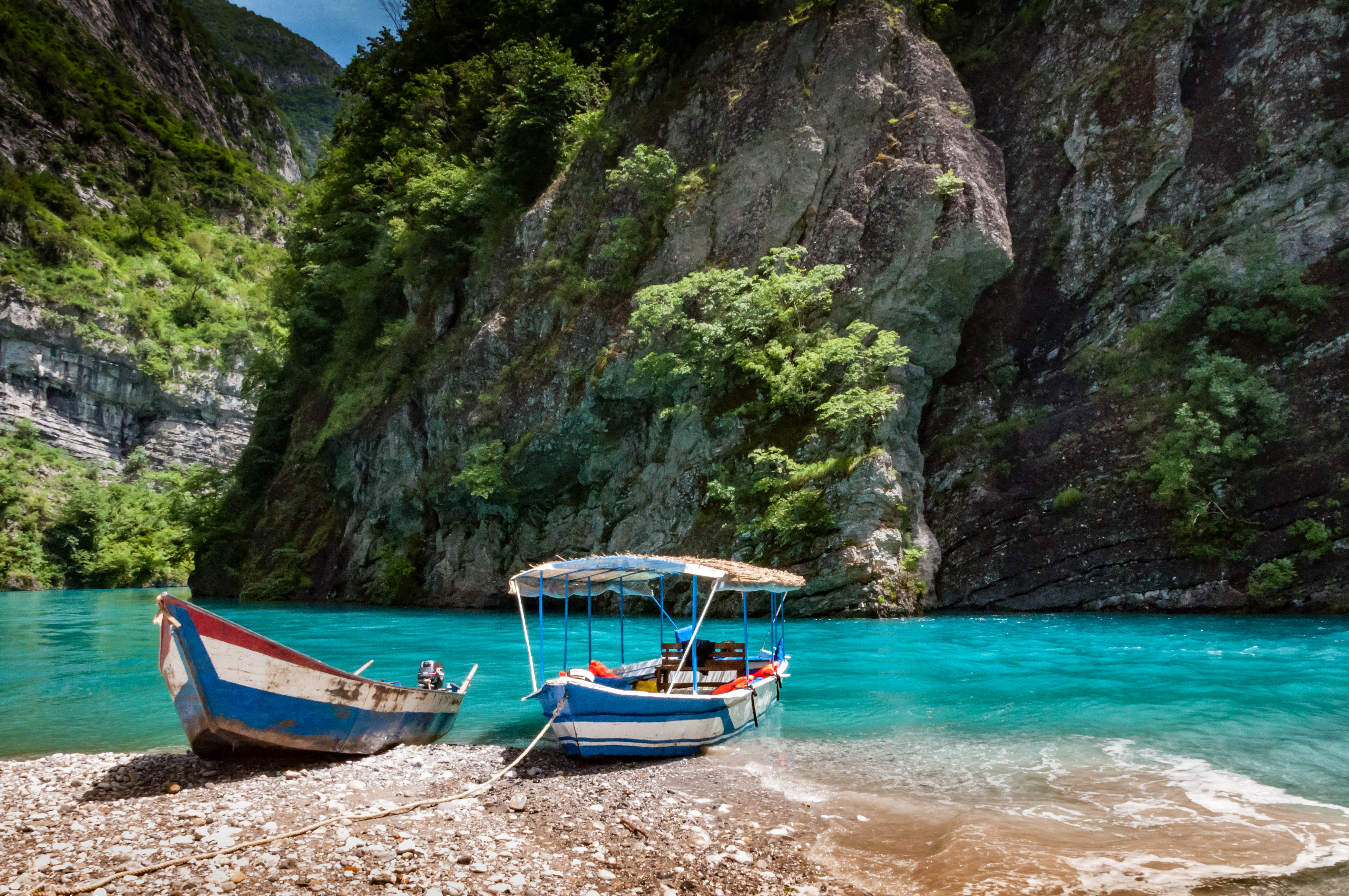 | Lake Koman is situated on the Drin river near the village of Koman next to the Albanian Alps. It covers an area of 12 km2 (4.63 sq mi) and a maximum depth of 175.5 m (576 ft).[14] Koman is a tourist attraction in northern Albania and sometimes comparable to the Scandinavian fjords, due to a number of rock formations, caves, canyons and waterfalls.[15] | |
| Lake Shkopet Liqeni i Shkopetit |  | Lake Shkopet is an artificial lake that covers an area of 6 km2 (2.32 sq mi). The reservoir is located in Mat, Dibër County within the Skanderbeg mountains north of the capital Tirana. | |
| Lake Bovilla Liqeni i Bovillës |  | Bovilla is reservoir with a surface area of 4.6 km2 (1.78 sq mi) and an average depth of 18 km (11.18 mi).[16] The reservoir is located in the northeast of Tirana and in the southeast of Krujë, within the Dajti National Park. The reservoir falls within the Mediterranean forests, woodlands, and scrub terrestrial ecoregion of the Palearctic temperate broadleaf and mixed forest. | |
See also
Wikimedia Commons has media related to Lakes of Albania.
- Biodiversity of Albania
- Climate of Albania
- Geography of Albania
- Protected areas of Albania
References
- "The quality of Albanian natural waters and the human impact". researchgate.net. p. 134.
- Engineering Geology for Society and Territory - Volume 1: Climate Change and Engineering Geology (Giorgio Lollino, Andrea Manconi, John Clague, Wei Shan, Marta Chiarle ed.). Springer. 23 August 2014. p. 388. ISBN 9783319093000.
- Pesic, Vladimir; Glöer, Peter (2013). "A new freshwater snail genus (Hydrobiidae, Gastropoda) from Montenegro, with a discussion on gastropod diversity and endemism in Skadar Lake". ZooKeys (281): 69–90. doi:10.3897/zookeys.281.4409. PMC 3677384. PMID 23794834. Retrieved 28 March 2013.
Despite the limited knowledge about the lake’s evolutionary history Glöer and Pešić (2008a) presumed status of Skadar Lake as an ancient lake.
- Pesic, Vladimir; Glöer, Peter (2013). "A new freshwater snail genus (Hydrobiidae, Gastropoda) from Montenegro, with a discussion on gastropod diversity and endemism in Skadar Lake". ZooKeys (281): 69–90. doi:10.3897/zookeys.281.4409. PMID 23794834. Retrieved 28 March 2013.
kadar Lake is the largest lake in the Balkan Peninsula with a surface area that seasonally fluctuates between 370 to 600 km2.
- "Natural and Cultural Heritage of the Ohrid region". whc.unesco.org. pp. UNESCO.
Situated on the shores of Lake Ohrid, the town of Ohrid is one of the oldest human settlements in Europe; Lake Ohrid is a superlative natural phenomenon, providing refuge for numerous endemic and relict freshwater species of flora and fauna dating from the tertiary period. As a deep and ancient lake of tectonic origin, Lake Ohrid has existed continuously for approximately two to three million years.
- "Lake Ohrid; Invest in Macedonia – Agency for Foreign Investments of the Republic of Macedonia". InvestInMacedonia.com. Archived from the original on 14 September 2008. Retrieved 3 June 2017.
- "Lake Ohrid; Invest in Macedonia – Agency for Foreign Investments of the Republic of Macedonia". InvestInMacedonia.com. Archived from the original on 14 September 2008. Retrieved 3 June 2017.
- "Management Plan Prespa National Park in Albania" (PDF). mjedisi.gov.al. p. 10. Archived from the original (PDF) on 2014-11-27. Retrieved 2017-07-17.
The park’s area can be characterized as a biodiversity hotspot.
- The Protection of Critical Energy Infrastructure Against Emerging Security Challenges (A. Niglia ed.). IOS Press. 9 October 2015. p. 131. ISBN 9781614995722.
- "Kesh - Albanian Power Corporation 2015" (PDF). kesh.al. p. 29.
The maximum volume of Vau i Dejës lake is 580 million m3. Its surface is 25km2
- "Specification" (PDF). kesh.al. p. 1.
The maximum volume of Vau i Dejës lake is 580 million m3.
- "Security Of The Energy Sector In Albania In The Face Of Climate Change". researchgate.net.
After the construction of the artificial Lake of Ulza (1957) and the hydropower facility of Shkopeti, the natural water regime of this river is mostly affected by energy plans for water use.
- "Liqeni I Ulzes in Albania". protectedplanet.net.
- "REHABILITATION OF KOMAN HYDRO POWER PLANT" (PDF). documents.worldbank.org. p. 10.
Maximum water level is 175.5 m asl, while maximum operation water level is little bit less, i.e. 172 m asl.
- "Albania - Bradt Travel Guides". Archived from the original on 2014-03-26. Retrieved 2015-05-18.
- "ENVIRONMENTAL ANALYSES OF BOVILLA WATERSHED (ALBANIA) – AN OVERVIEW" (PDF). p. 22.
The surface of the Reservoir amounts of 4.6 km2; its average depth is 18 m.
Albania articles | |||||||||||||||||||||||||||||
|---|---|---|---|---|---|---|---|---|---|---|---|---|---|---|---|---|---|---|---|---|---|---|---|---|---|---|---|---|---|
| History |
|  | |||||||||||||||||||||||||||
| Geography |
| ||||||||||||||||||||||||||||
| Politics |
| ||||||||||||||||||||||||||||
| Economy |
| ||||||||||||||||||||||||||||
| Society |
| ||||||||||||||||||||||||||||
| |||||||||||||||||||||||||||||
| Authority control: National libraries |
|---|
На других языках
[de] Liste der Seen in Albanien
Ohrid- und Prespaseen Liste bedeutender Seen in Albanien SeeFläche (max.)Tiefe (max.)Höhe Skutarisee368 km²[1]044 m00±6 m Ohridsee349 km²[2]288 m0695 m Prespasee273 km²[3]054 m0853 m Fierza-Stausee072 km²[4]128 m0295 m Kleiner Prespasee045 km²[5]009 m0856 m Lagune von Karavasta045 km²001,3 m00±0 m Lagune von Narta026,7 km²000,9 m00±0 m Vau-Deja-Stausee024,7 km²052 m0076 m Butrintsee016 km²021 m00±0 m Banja-Stausee 014 km² 070 m (ca.) 0175 m Koman-Stausee012 km²096 m0172 m Wasserspeicher Thana 005,91 km² 0 0028 m Bovilla-Reservoir004,6 km²045 m0321 m Lura-Seen000,5 km² 1720 m Dumreja-Seen (85)014,2 km²061 m0150 m Çestinja-See (Dumreja)000,968 km² 0109 m Seferan-See (Dumreja)000,875 km²021 m0127 m Merhoja-See (Dumreja)000,655 km²061 m0120 m Grama-See 000,05 km² 1761 m Davon 149 km² in Albanien und 219 km² in Montenegro. Der größere Teil gehört zur Republik Nordmazedonien, der kleinere zu Albanien. Prespasee liegt im Dreiländereck Mazedonien, Albanien und Griechenland. Davon ein kleiner Teil in Kosovo. Der kleine Prespasee liegt mehrheitlich in Griechenland.- [en] List of lakes of Albania
Текст в блоке "Читать" взят с сайта "Википедия" и доступен по лицензии Creative Commons Attribution-ShareAlike; в отдельных случаях могут действовать дополнительные условия.
Другой контент может иметь иную лицензию. Перед использованием материалов сайта WikiSort.org внимательно изучите правила лицензирования конкретных элементов наполнения сайта.
Другой контент может иметь иную лицензию. Перед использованием материалов сайта WikiSort.org внимательно изучите правила лицензирования конкретных элементов наполнения сайта.
2019-2025
WikiSort.org - проект по пересортировке и дополнению контента Википедии
WikiSort.org - проект по пересортировке и дополнению контента Википедии