geo.wikisort.org - Reservoir
The Lake Prespa is located on the tripoint of North Macedonia, Albania, and Greece. It is a system of two lakes separated by an isthmus: the Great Prespa Lake, divided between the three countries, and the Little Prespa Lake, mostly within Greece. They are the highest tectonic lakes in the Balkans, standing at an elevation of 853 metres (2,799 ft).
| Lake Prespa | |
|---|---|
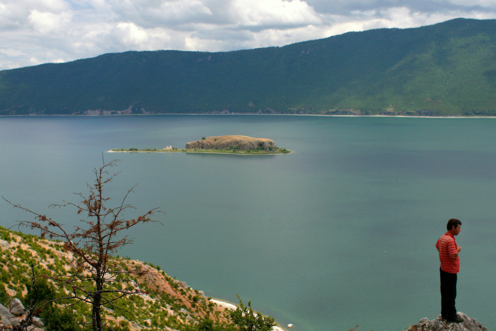
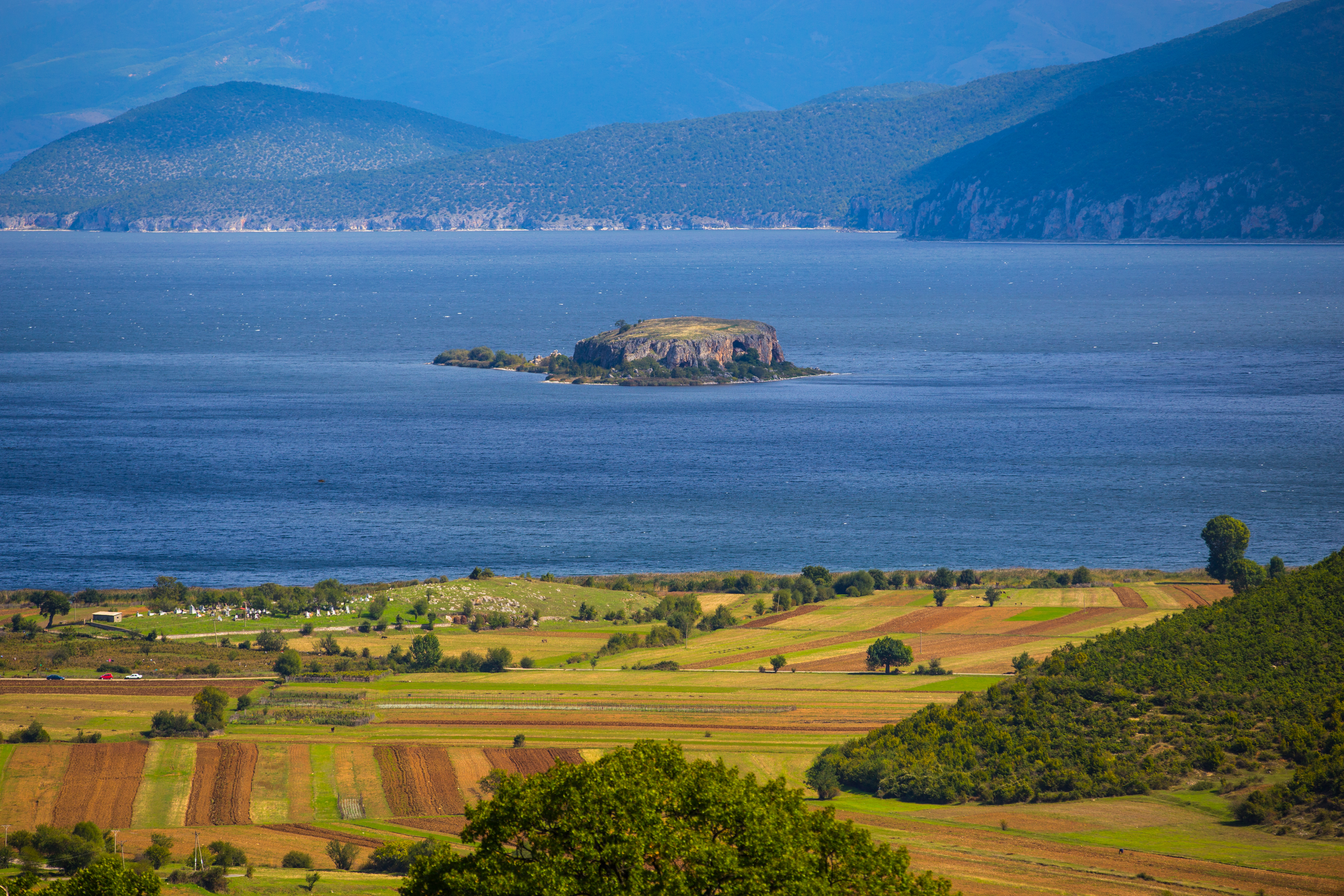 The Island of Maligrad in the Albanian part of the Lake | |
 Lake Prespa  Lake Prespa  Lake Prespa  Lake Prespa  Lake Prespa | |
 Location | |
| Location | Balkans (North Macedonia, Albania, Greece) |
| Coordinates | 40°54′N 21°02′E |
| Type | Ancient lake, tectonic |
| Primary outflows | Lake Ohrid via karstic channels |
| Basin countries | North Macedonia, Albania, Greece |
| Surface area | 259 km2 (100 sq mi) |
| Max. depth | 54 m (177 ft) |
| Surface elevation | 853 m (2,799 ft) |
| Islands | Golem Grad, Mal Grad |
 | |
Ramsar Wetland | |
| Official name | Lake Prespa |
| Designated | 4 April 1995 |
| Reference no. | 726[1] |
Ramsar Wetland | |
| Official name | Albanian Prespa Lakes |
| Designated | 13 June 2013 |
| Reference no. | 2151[2] |
The area contains three national parks: Prespa in Albania, Galičica in North Macedonia and Prespa in Greece. The largest town in the region is Resen in North Macedonia. In 2014, the Ohrid-Prespa Transboundary Reserve between Albania and North Macedonia was added to UNESCO's World Network of Biosphere Reserves.[3]
Geography
The Great Prespa Lake (Macedonian: Преспанско Езеро, Prespansko Ezero, Albanian: Liqeni i Prespës së Madhe, Greek: Μεγάλη Πρέσπα, Megáli Préspa) has the total surface of 259 km2 (100.00 sq mi). The largest part of it, 176.3 km2 (68.07 sq mi) belongs to North Macedonia; 46.3 km2 (17.88 sq mi) to Albania; and 36.4 km2 (14.05 sq mi) to Greece.
To the south, the Little Prespa Lake[4] (Greek: Μικρή Πρέσπα, Mikri Prespa; Albanian: Prespa e Vogël; Macedonian: Мало Преспанско Езеро) has the total surface area of 46.8 km2 (18.07 sq mi), most of it in Greece, with the westernmost tip (4.3 km2 (1.66 sq mi)) in Albania.
The two lakes are separated by a 4 km (2½ miles) long and 500 metres (550 yards) wide isthmus on the Greek territory, carrying an embankment with a road connecting the village of Psarades. A short stretch of a canal connects the lakes on the western side of the isthmus.
History

In Classical times, the Prespa region formed part of ancient Lýnkos (Λύγκος), and the lakes were called Little and Great Brygeis. In the 10th century, the Tsar Samuil built the fortress and church of St. Achillius on an island called Agios Achillios in the Small Prespa Lake, on the Greek side of the border. The biggest island in the Great Prespa Lake, within North Macedonia, is called Golem Grad ("Large Town"), and Snake Island (Zmiski Ostrov). The other island Mal Grad ("Small Town", in Albania) is the site of a ruined 14th century monastery dedicated to St. Peter. Today, both islands are uninhabited.
Because Great Prespa Lake sits in limestone country about 150m above Lake Ohrid, which lies only about 10 km (6 miles) to the west, the only outlets for its waters are through underground channels in the karst and emerge from springs which feed streams running into Lake Ohrid.[5]
For many years, the Greek part of the Prespa Lakes region was an underpopulated, military sensitive area which required special permission for outsiders to visit. It saw fierce fighting during the Greek Civil War and much of the local population subsequently emigrated to escape endemic poverty and political strife. The region remained little developed until the 1970s, when it began to be promoted as a tourist destination. With an abundance of rare fauna and flora, the area was declared a Transnational Park in 2000. In 1999 the Society for the Protection of Prespa received the Ramsar Wetland Conservation Award for its conservation efforts regarding the Lake Prespa Ramsar site, and was eventually included on 3 July 2013.
In 2018, Great Prespa Lake was the setting for the signing of the Prespa Agreement, intended to resolve the Macedonia naming dispute by renaming the Republic of Macedonia to North Macedonia.[6] The agreement was signed on 17 June 2018 in a high-level ceremony at the Greek border village of Psarades on the lake, by the two foreign ministers Nikola Dimitrov (of the Republic of Macedonia) and Nikos Kotzias (of Greece) and in the presence of the respective prime ministers, Zoran Zaev and Alexis Tsipras.[7] After the ceremony, Tsipras and Zaev crossed over the border to North Macedonia's side of the lake for lunch at the village of Oteševo, in a highly symbolic move that marked the first time a Greek prime minister ever entered the Republic of Macedonia since it declared independence in 1991.[8]
Wildlife
Only 11 native fish species are known from the lake, but 9 of these are endemic: Alburnoides prespensis, Alburnus belvica, Barbus prespensis, Chondrostoma prespense, Cobitis meridionalis, Pelasgus prespensis, Rutilus prespensis, Salmo peristericus and Squalius prespensis; the additional two are Anguilla anguilla (European eel) and Cyprinus carpio (European carp).[9]
Important Bird Areas
North Macedonia's part of the lake has been designated an Important Bird Area (IBA) by BirdLife International because it supports populations of ferruginous ducks, tufted ducks, Dalmatian pelicans and pygmy cormorants.[10] The Albanian part of the lake is a separate but corresponding IBA for the same reason,[11] as is the Greek southern section of the lake.[12]
Gallery
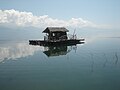 Fisherman's hut in Oteševo, North Macedonia
 Beach "Ribarsko Selo" in Oteševo, North Macedonia
 Beach at Konjsko, North Macedonia
 Prespa as seen from Oteševo - Stenje route in North Macedonia
 The lake as seen from Oteševo - Stenje route
 "Evropa" hotel in Oteševo, now abandoned
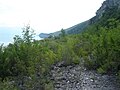 The southern shoreline (Stenje - Konjsko)
 Fisherman's huts at "Ribarsko Selo"
 Shoreline along the Greek side
 View from Greek side
 Cliff face around Greek side
 Maligrad Island in Albania


Tourism
Lake Prespa in North Macedonia has not commanded a large tourism population in the past. The majority of foreign tourism has been clustered around the sister lake, Ohrid, where there are abundant overnight accommodations, restaurants and a lively town center in the summer months. Lake Prespa has subsequently remained somewhat isolated and pastoral, bringing its own special attraction in current times. The area remains pristine, without the hustle and bustle of a tourist town and a distinct lack of concrete and pollution which usually comes with developing tourism. Waterfront developments with sophisticated cafes serving food and drinks such as "Connect Beach" in the village of Slivnica, however, are providing a way for visitors to spend the day on the lake in luxury, without impacting on the environment. Companies such Prespa Panorama based in North Macedonia are leading the development of overnight lodging for the region with a concept of low environmental impact, low volume accommodations in the region. The municipality of Resen has begun construction of a paved walking and biking path that will link the individual villages providing access for a walking or biking tour of the numerous villages that are scattered around the lake. The completed concept will allow individuals to explore the entire south western corner of North Macedonia including Pelister and Galicica, two of the most beautiful and scenic mountain peaks of the region on foot or by bicycle. A descent from Galicica on the western face brings the cyclist or hiker down to the most scenic part of Lake Ohrid, which is separated from Lake Prespa by its massif. Once on the Lake Ohrid side, the springs where the waters of Lake Prespa emerge from under the mountain and drain into Lake Ohrid can be enjoyed.
Sources
- "Prespa, Lake". Encyclopædia Britannica, 2005.
- "Prespa, Lake". The Columbia Encyclopedia, 2004.
See also
- Prespa National Park
- Prespa, adjacent region in North Macedonia
- Prespes, adjacent municipality in Greece
- Prespa e Vogël and Golloborda, adjacent region in Albania
References
- "Lake Prespa". Ramsar Sites Information Service. Retrieved 25 April 2018.
- "Albanian Prespa Lakes". Ramsar Sites Information Service. Retrieved 25 April 2018.
- Thirteen sites added to UNESCO’s World Network of Biosphere Reserves – UNESCO
- Kapka Kassabova, To the Lake, Granta 2020, map 1 gives simply Lake Prespa and Little Prespa, not Great and Small Prespa
- Thomas Wilke, Risto Väinolä, Frank Riedel (2009), Patterns and Processes of Speciation in Ancient Lakes: Proceedings of the Fourth Symposium on Speciation in Ancient Lakes, Berlin, Germany, September 4–8, 2006 (Developments in Hydrobiology), p. 107, Springer, ISBN 1-4020-9581-3
- "FINAL AGREEMENT FOR THE SETTLEMENT OF THE DIFFERENCES AS DESCRIBED IN THE UNITED NATIONS SECURITY COUNCIL RESOLUTIONS 817 (1993) AND 845 (1993), THE TERMINATION OF THE INTERIM ACCORD OF 1995, AND THE ESTABLISHMENT OF A STRATEGIC PARTNERSHIP BETWEEN THE PARTIES" (PDF). Kathimerini. Retrieved 13 June 2018.
- "Greece, Macedonia sign pact to change ex-Yugoslav republic's name". Reuters. 17 June 2018. Retrieved 17 June 2018.
- "Prespa: Alexis Tsipras is the first Greek prime minister to visit FYROM (original: Πρέσπες: Ο Αλέξης Τσίπρας είναι ο πρώτος Έλληνας πρωθυπουργός που επισκέφθηκε την πΓΔΜ)". HuffPost. 17 June 2018. Retrieved 17 June 2018.
- Talevski, T.; Milosevic, D.; Maric, D.; Petrovic, D.; Talevska, M.; Talevska, A. (2009). "Biodiversity of Ichthyofauna from Lake Prespa, Lake Ohrid and Lake Skadar". Biotechnology & Biotechnological Equipment. Informa UK Limited. 23 (sup1): 400–404. doi:10.1080/13102818.2009.10818449. ISSN 1310-2818. S2CID 84541133.
- "Lake Prespa". BirdLife Data Zone. BirdLife International. 2021. Retrieved 11 March 2021.
- "Lake Megali Prespa". BirdLife Data Zone. BirdLife International. 2021. Retrieved 11 March 2021.
- "Prespa National Park and Varnountas mountains". BirdLife Data Zone. BirdLife International. 2021. Retrieved 11 March 2021.
External links
 Media related to Lake Prespa at Wikimedia Commons
- Archived webpage of Transboundary Prespa Park
- Archived webpage of Prespa National Park Official Website
North Macedonia articles | ||||||||||||
|---|---|---|---|---|---|---|---|---|---|---|---|---|
| History |
|  | ||||||||||
| Geography |
| |||||||||||
| Politics |
| |||||||||||
| Economy |
| |||||||||||
| Society |
| |||||||||||
| ||||||||||||
| Natural Lakes |
| ||||
|---|---|---|---|---|---|
| Artificial | |||||
| Urban Tirana |
| ||||
Albania articles | |||||||||||||||||||||||||||||
|---|---|---|---|---|---|---|---|---|---|---|---|---|---|---|---|---|---|---|---|---|---|---|---|---|---|---|---|---|---|
| History |
|  | |||||||||||||||||||||||||||
| Geography |
| ||||||||||||||||||||||||||||
| Politics |
| ||||||||||||||||||||||||||||
| Economy |
| ||||||||||||||||||||||||||||
| Society |
| ||||||||||||||||||||||||||||
| |||||||||||||||||||||||||||||
| |||||||||||||||||||||||||||
| |||||||||||||||||||||||||||
| |||||||||||||||||||||||||||
| |||||||||||||||||||||||||||
| |||||||||||||||||||||||||||
| |||||||||||||||||||||||||||
| |||||||||||||||||||||||||||
Authority control | |
|---|---|
| General |
|
| National libraries | |
На других языках
[de] Prespasee
Der Große Prespasee oder einfach nur Prespasee (mazedonisch Преспанско Езеро .mw-parser-output .Latn{font-family:"Akzidenz Grotesk","Arial","Avant Garde Gothic","Calibri","Futura","Geneva","Gill Sans","Helvetica","Lucida Grande","Lucida Sans Unicode","Lucida Grande","Stone Sans","Tahoma","Trebuchet","Univers","Verdana"}Prespansko Ezero; albanisch Liqen/-i i Prespës; griechisch Λίμνη Μεγάλη Πρέσπα Límni̱ Megáli̱ Préspa) ist ein See im Dreiländereck von Nordmazedonien, Albanien und Griechenland im Inneren der Balkanhalbinsel.- [en] Lake Prespa
[es] Lago Prespa
Los lagos Prespa son dos lagos de agua dulce, Prespa e Madhe y Prespa e Vogël , en Europa suroriental, compartidos entre Albania (38,8 km²), Grecia (84,8 km²) y Macedonia del Norte (190 km²). Se ubican a una altura de 853 metros. El lago grande está compartido entre los tres países, recibiendo los nombres de Преспанско Езеро, Prespansko Ezero (macedonio); Μεγάλη Πρέσπα, Limni Megáli Préspa (griego) y Liqeni i Prespes (albanés). El lago más pequeño solo está compartido entre Grecia (43,5 km²; griego: Μικρή Πρέσπα, Limni Mikrá Prespa) y Albania (3,9 km²; Prespa e Vogël). Son los lagos tectónicos más altos de los Balcanes, en una altitud de 853 msnm.[fr] Lac Prespa
Le lac Prespa ou Grand lac Prespa pour le distinguer du Petit lac Prespa, en albanais Liqeni i Prespës, en grec Λίμνη Μεγάλη Πρέσπα / Limni Megáli Préspa, en macédonien Преспанско Езеро, Prespansko Ezero, est un lac partagé entre l'Albanie (38,8 km2), la Grèce (84,8 km2) et la Macédoine du Nord (190 km2). Il est situé à une altitude de 853 mètres.[it] Lago Prespa
Prespa è il nome di due laghi di origine tettonica che si trovano tra Grecia, Macedonia del Nord e Albania.[ru] Преспа
Пре́спа[1] (макед. Преспанско Езеро, греч. Μεγάλη Πρέσπα, алб. Prespa e Madhe) — озеро в Восточной Европе. Площадь поверхности — 273 км². Преспа поделена между Северной Македонией, Грецией (41,3 км²) и Албанией (34,9 км²). Связано протокой с озером Микра-Преспа[1]. Эти озёра — самые высоко расположенные тектонические озёра на Балканском полуострове, расположены на высоте 853 м.Другой контент может иметь иную лицензию. Перед использованием материалов сайта WikiSort.org внимательно изучите правила лицензирования конкретных элементов наполнения сайта.
WikiSort.org - проект по пересортировке и дополнению контента Википедии