geo.wikisort.org - Reservoir
Lake Skadar (Serbo-Croatian: Скадарско језеро, Skadarsko jezero, pronounced [skâdarskɔː jɛ̂zɛrɔ]; Albanian: Liqeni i Shkodrës, pronounced [liˈcɛni i ˈʃkɔdrəs]) – also called Lake Scutari, Lake Shkodër and Lake Shkodra – lies on the border of Albania and Montenegro, and is the largest lake in Southern Europe. It is named after the city of Shkodër in northern Albania (Albanian: Shkodër or Shkodra; Serbo-Croatian: Скадар, Skadar; Italian: Scutari). It is a karst lake.
| Lake Skadar | |||||||||||||||
|---|---|---|---|---|---|---|---|---|---|---|---|---|---|---|---|
| Lake Shkodër, Lake Shkodra, Lake Scutari | |||||||||||||||
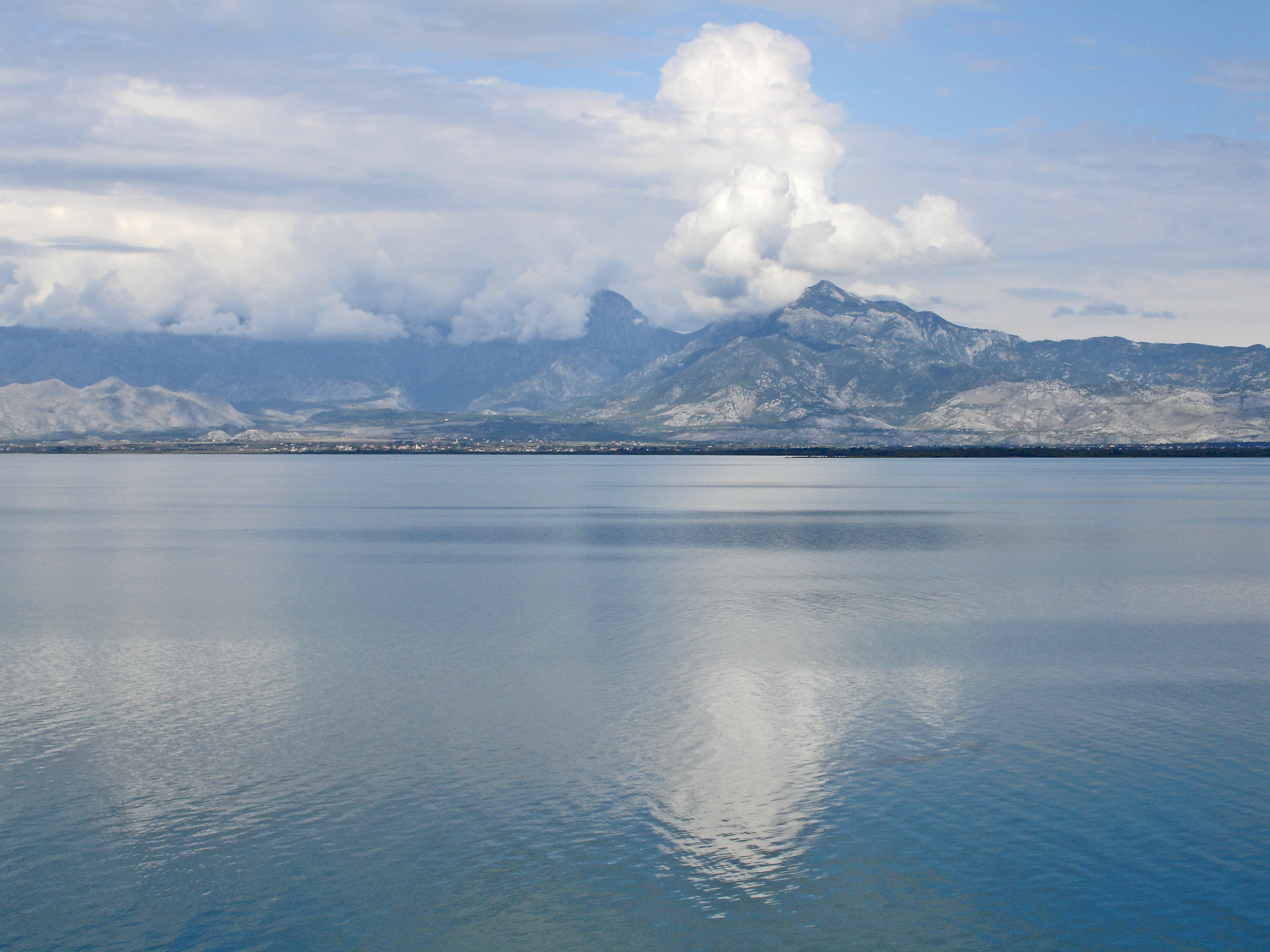 Shkodra Lake and Maranaj Mountain (1576 m) in Albania | |||||||||||||||
 Lake Skadar  Lake Skadar | |||||||||||||||
| Location | Albania–Montenegro border | ||||||||||||||
| Coordinates | 42°10′N 19°19′E | ||||||||||||||
| Primary inflows | Morača | ||||||||||||||
| Primary outflows | Bojana | ||||||||||||||
| Basin countries | Albania, Montenegro | ||||||||||||||
| Max. length | 44 km (27 mi) | ||||||||||||||
| Max. width | 14 km (8.7 mi) | ||||||||||||||
| Surface area | 370–530 km2 (140–200 sq mi) | ||||||||||||||
| Average depth | 5.01 m (16.4 ft) | ||||||||||||||
| Max. depth | 8.3 m (27 ft)[1] 44 m (144 ft)[citation needed] | ||||||||||||||
| Water volume | 1,931.62×106 m3 (68.215×10⁹ cu ft) | ||||||||||||||
| Shore length1 | 207 km (129 mi) is total length of coastline (including islands). | ||||||||||||||
| Surface elevation | 6 m (20 ft) | ||||||||||||||
| References | [1] | ||||||||||||||
Ramsar Wetland | |||||||||||||||
| Official name | Skadarsko Jezero | ||||||||||||||
| Designated | 13 December 1995 | ||||||||||||||
| Reference no. | 784[2] | ||||||||||||||
Ramsar Wetland | |||||||||||||||
| Official name | Lake Shkodra and River Buna | ||||||||||||||
| Designated | 2 February 2006 | ||||||||||||||
| Reference no. | 1598[3] | ||||||||||||||
|
| |||||||||||||||
| 1 Shore length is not a well-defined measure. | |||||||||||||||


The Montenegrin section of the lake and surrounding land has been designated as a national park, while the Albanian section is a nature reserve and a ramsar site.
Geography
Lake Skadar is the largest lake in the Balkan Peninsula with a surface area that seasonally fluctuates between 370 km2 (140 sq mi) and 530 km2 (200 sq mi).[1] Lake Skadar itself is located on the western Balkan
The lake is located in the border area between Albania and Montenegro, the Montenegrin share of the area of the lake is slightly larger than the Albanian. The lake's water level also varies seasonally from 4.7 to 9.8 metres (15 to 32 ft) above sea level. The lake extends northwest to southeast, and it is approximately 44 km (27 miles) long.[1]
The Bojana River connects the lake with the Adriatic Sea, and the Drin River provides a link with the Ohrid Lake.[1] The lake is a cryptodepression, filled by the river Morača and drained into the Adriatic by the 41 km (25 mi) long Bojana (Albanian: Buna), which forms the international border on the lower half of its length. The largest inflow is from the Morača, which provides about 62% of the lake's water.[1] Total drainage area is 5,490 km2 (2,120 sq mi).[1]
There are additionally some fresh water sources at the lake bottom. A characteristic feature of Lake Skadar's water balance is the high inflow from a number of temporary and permanent karstic springs, some of which are sublacustrine in cryptodepressians (so-called ‘oko’).[1] The Southern and southwestern sides of the lake are rocky, barren and steep, having bays in which the sublacustrine springs, are usually to be found.[1] On the northern side there is an enormous inundated area, the boundaries of which change as water levels fluctuate.[1]
Some small islands like Beška, with two churches on it and Grmožur, a former fortress and prison can be found on the southwestern side of the lake.
The climate type is hot-summer Mediterranean climate with dry summers (Csa), under Köppen climate classification.[1]
The Montenegrin part of the lake and its surrounding area were declared a national park in 1983. The Albanian part has been designated as a Managed Nature Reserve. In 1996, by Ramsar Convention on Wetlands, it was included in the Ramsar list of wetlands of international importance.[4] Near the mouth of Rijeka Crnojevića, 11 m (36 ft) below the surface of the water there is a well-preserved wreck of the steamboat Skanderbeg sunk by partisans in 1942, during the Second World War.[5]
 View of the lake, Albania
 Western part of the lake near Rijeka Crnojevića, Montenegro
 Horseshoe bend in the northwest corner
 Outflow at Shkodër in Albania
 Fortress Grmožur in Lake Skadar, Montenegro
 Lake Skadar, Montenegro


Geology
Lake Skadar is presumably an ancient lake, although it is a relatively young ancient lake.[1]
Most authors agree that the Lake Skadar basin is of tectonic origin which had been formed due to the complex folding and faulting within north eastern wing of Old Montenegro anticlynorium (High Karst Zone).[1] These movements took place during the Cenozoic period. The Lake basin has been formed as the result of sinking of blocks in the Neogene period or even in Paleogene.[1] In the Miocene and the Pliocene marine conditions prevailed in the Zeta Plain, which was sunk at the beginning of the upper Miocene, and that the sea inundated this plain up to Podgorica during the Pliocene.[1] Radoman (1985)[6] pointed out that sea must have destroyed all the freshwater populations on this plane and in the Lake Skadar area.[1] The connection of Lake Skadar with the sea was interrupted during the younger Pliocene.[1] The question of the origin of its water is of particular interest for biologists as these waters may have provided its first species and been the basis for its present high degree of endemism.[1]
Fauna
The Lake Skadar system is a well-known hotspot of freshwater biodiversity and harbors a highly diverse mollusc fauna.[1]
Lake Skadar is one of the largest bird reserves in Europe, having 270 bird species, among which are some of the last pelicans in Europe, and thus popular with birders. The lake also contains habitats of seagulls and herons.
It is abundant in fish, especially in carp, bleak and eel. Of the 34 native fish species, 7 are endemic to Lake Skadar.[7]
At the scale of Lake Skadar, about 31% of freshwater snails (12 out of 39 species sampled in the lake) are endemic.[1] At the scale of the Lake Skadar basin, 38% (19 species) of the total freshwater gastropod fauna appear to be endemic.[1] There were reliably recorded 50 species of freshwater snails from the Lake Skadar basin.[1] The index of freshwater gastropod endemism is 0.478.[1] With this relatively high value, Lake Skadar exceeds such famous lakes as Lake Malawi and Lake Titicaca.[1] The Lake Skadar is inhabited by five species of Bithynia and it is a hot spot of Bithynia evolution.[1]
There are 17 amphipod species for the Lake Skadar watershed, 10 of them being endemic (mainly from the subterranean habitat).[1]
The small range of many endemic species living in the Lake Skadar system together with ever increasing human pressure make its fauna particularly vulnerable.[1] This becomes even more important in light of ongoing eutrophication, water pollution and sand and gravel exploration activities in the lake and its basin.[1] Research of the phytoplankton community and chlorophyllbased trophic state indices show that the lake is on a betamesosaprobic level of saprobity, which means moderately polluted with organic compounds.[1] Effects of human-induced environmental changes are especially evident for sublacustrine springs, with eutrophication and using for water supplying (e.g., sublacustrine spring Karuč) being the most serious threats.[1]
The 2011 IUCN Red List of Threatened Species includes 21 endemic species from the Lake Skadar basin.[1]
Cultural impact
Radio Skadar, a radio station in Montenegro, based in Podgorica is named after Lake Skadar.
See also
References
- Pešić V. & Glöer P. (2013). "A new freshwater snail genus (Hydrobiidae, Gastropoda) from Montenegro, with a discussion on gastropod diversity and endemism in Skadar Lake". ZooKeys 281: 69-90. doi:10.3897/zookeys.281.4409
- "Skadarsko Jezero". Ramsar Sites Information Service. Retrieved 25 April 2018.
- "Lake Shkodra and River Buna". Ramsar Sites Information Service. Retrieved 25 April 2018.
- Ramsar (August 4, 2010). "The list of wetlands of international importance" (PDF) (in English and Spanish). Ramsar. p. 5. Retrieved 14 August 2010.
- Vukotić, Jovan D. (1983). Borbena dejstva u savlađivanju vodenih prepreka u NOR-u: 1941-1945. Vojnoizdavački zavod. p. 14.
Батаљон Ловћенског НОП одреда »Царев Лаз« је у садејству са деловима батаљона »13. јули« 12. фебруара 1942. извршио препад на италијански пароброд »Скендербег« на Скадарском језеру...
- Radoman P. (1985). "Hydrobioidea a superfamily Prosobranchia (Gastropoda), II. Origin, Zoogeography, Evolution in the Balkans and Asia Minor". Monographs Institute of Zoology Belgrade 1: 1-173.
- Talevski, Milošević, Marić, Petrović, Talevska and Talevska (2009). Biodiversity of Ichthyofauna from Lake Prespa, Lake Ohrid and Lake Skadar. Biotechnology & Biotechnological Equipment, 23(2). ISSN 1310-2818
| Administrative centre |
|
|---|---|
| Subdivisions |
|
| Landmarks |
|
| National parks |
|
| Culture |
|
| Institutions |
|
| Education |
|
| Sport clubs |
|
| Media |
|
| History |
|
| Urban municipalities |
|  |
|---|---|---|
| Neighborhoods |
| |
| Municipality settlements | List
| |
| Geography | ||
| Landmarks |
| |
| Culture |
| |
| Sports venues |
| |
| Sport clubs |
| |
| Events |
| |
| Education |
| |
| Media |
| |
| Shopping malls |
| |
| Companies |
| |
| Transportation | ||
| Natural Lakes |
| ||||
|---|---|---|---|---|---|
| Artificial | |||||
| Urban Tirana |
| ||||
Authority control | |
|---|---|
| General |
|
| National libraries | |
На других языках
[de] Skutarisee
Der Skutarisee (auch Shkodrasee oder Skadarsee; albanisch Liqen/-i i Shkodrës, serbisch und montenegrinisch Скадарско језеро .mw-parser-output .Latn{font-family:"Akzidenz Grotesk","Arial","Avant Garde Gothic","Calibri","Futura","Geneva","Gill Sans","Helvetica","Lucida Grande","Lucida Sans Unicode","Lucida Grande","Stone Sans","Tahoma","Trebuchet","Univers","Verdana"}Skadarsko Jezero, historisch auch italienisch Lago di Scutari) ist der größte See der Balkanhalbinsel und – je nach Ansicht – neben dem Gardasee der größte See Südeuropas. Die hier verwendete Bezeichnung hat der See nach dem früher verwendeten italienischen Namen der an der Südostspitze des Sees gelegenen albanischen Stadt Shkodra (serbisch/montenegrinisch Скадар/Skadar). Der See liegt im Grenzgebiet zwischen Montenegro und Albanien, der montenegrinische Anteil an der Fläche des Sees ist etwas größer als der albanische. Nach Südwesten ist er durch das bis zu 1600 Meter hohe Gebirge Rumija von der nur 20 Kilometer entfernt liegenden Adria getrennt, während sich an der Nordostseite ein weit gedehntes, teilweise versumpftes Flachland anschließt.- [en] Lake Skadar
[es] Lago Shkodër
El lago Shkodër, lago Shkodra o lago Skadar (albanés: Liqeni i Shkodrës, serbio: Skadarsko jezero/Скадарско језеро), también llamado a veces lago Scutari (toponimia de origen italiano), es un lago situado en la frontera entre Montenegro y Albania. Sus distintos nombres derivan del de Shkodra, una ciudad del norte de Albania.[fr] Lac de Shkodra
Lac Skadar[it] Lago di Scutari
Il lago di Scutari (in albanese: Liqeni i Shkodrës; in montenegrino: Skadarsko jezero) è il più grande lago della penisola balcanica.[1][ru] Шкодер (озеро)
Шко́дер[3][4][2] (алб. Shkodër)[5] или Скада́рское о́зеро[3][4][2] (Скадарско[1]; черног. Skadarsko[5]; устар.: Скутарийское озеро[6], Скандерское[7], Скадрское[8], Скадара[8], Скутари[8]) — крупнейшее озеро Балканского полуострова, располагается на территории Черногории и Албании. Площадь водной поверхности озера составляет около 390 км², но может увеличиваться до 530 км² в зимнее половодье. В среднем площадь составляет 475 км², из которых около 2/3 озера принадлежит Черногории, остальная часть принадлежит Албании[5][9].Другой контент может иметь иную лицензию. Перед использованием материалов сайта WikiSort.org внимательно изучите правила лицензирования конкретных элементов наполнения сайта.
WikiSort.org - проект по пересортировке и дополнению контента Википедии