geo.wikisort.org - Coast
The Karaburun Peninsula (Albanian: Gadishulli i Karaburunit) is a peninsula of the Mediterranean Sea located in Southern and Southeastern Europe, which is almost completely surrounded by both the Adriatic Sea to the north and the Ionian Sea to the south. It is located in Southwestern Albania along the Albanian Ionian Sea Coast, whereas the Strait of Otranto separates it from Italy. The Strait of Mezokanal separates the peninsula from Sazan Island, while in the southeast stretches the Bay of Vlorë. Its name “Karaburun” derives from Turkish for "black cape". In classical antiquity, its name was the "Akrokeraunian Peninsula" (Ακροκεραύνιο ακρωτήριο), whose name was derived from the eponymous Akrokeraunian mountains;this is because in terms of geology, the Rrëza e Kanalit on the peninsula represent the continuation of said mountains, which are the highest and most extensive mountain range system that extends parallel to the Ionian Sea.[1] Karaburun peninsula is sometimes called Ceraunian Peninsula due to the name of the mountain range.[2][3] Created during the mesozoic era of the cretaceous and paleogene period, the crests of the mountain range form a northwest-southeast line with a series of distinct peaks along its irregular structure that are broken apart by steep and unequally slopes.[4] The highest peaks are namely, the Maja Çaderës, Maja e Flamurit, Maja e Koretës and Maja e Ilqes.
Albanian: Gadishulli i Karaburunit | |
|---|---|
 Satellite imagery of Karaburun Peninsula | |
| Geography | |
| Location | Vlorë County, Albania Southern Europe |
| Coordinates | 40°20′N 19°22′E |
| Adjacent to | |
| Area | 62 km2 (24 sq mi) |
| Highest point | Maja Çaderës (839 mAA) |
The western section comprises a rough relief and is dotted with sandy and rocky beaches, sea caves, steep cliffs and several bays amongst them Cave of Haxhi Ali, Cape of Gjuhëz, Bay of Skaloma, Bay of Arushë, Bay of Dafinë, and most notably Bay of Grama, where ships and vessels anchored during classical antiquity. On the high and steep rock faces of the bay, which served also as a marble quarry, there are hundreds of rock inscriptions dating back to the 4th century BC.[5][6][7][8][9]
Under the Köppen climate classification, the peninsula experiences a mediterranean climate with hot summers and generally warm to cool, dry winters. The ideal climate and contrasting landscapes located at the sea have favored the development of a vast array of habitats which in turn are home to a diverse wildlife. The fauna is represented by several threatened and endangered species such as the loggerhead and green sea turtle but also the mediterranean monk seal, the rarest seal species in the world.[10][11][12]
The landmass of the peninsula is designated as nature reserve, while the shoreline and its surrounding sea waters are part of the marine park.[13][14][15][16] In 2014, the Regina Blu ferry was established by a Radhime-based hotel owner making trips between the peninsula and the island of Sazan, while stopping along the secluded beaches.[17]
The peninsula belongs to the Sazan Zone that is a constituent of the Albanides tectonic unit. Albanides form the link between Dinarides and Hellenides orogenic belts. They are considered allocthonous and mobilist theories deduce they come from the east.[18] These formations have been continuously under the effect of Karst and are exploited as marble (metamorphosed limestone) since antiquity.[19] The widespread Karst topography is responsible for the absence of potable water and thus the absence of any population on the peninsula. Despite the dry surface and upper soil layers, there are several water sources that pour deep directly into the sea. The geological evolution has formed also capes such as Galloveci cape and Kepi i Gjuhëzës, as well as a total number of 20 caves along the whole coast.[20]
Gallery
 Bay of Skaloma
 Bay of Grama
 Cave of Dafinë
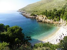 Bay of Arushë
 Cave of Haxhi Ali


See also
- Albanian Ionian Sea Coast
- Karaburun-Sazan National Marine Park
- Biodiversity of Albania
- Geography of Albania
- Protected areas of Albania
References
- "Management Plan Llogora-Rreza e Kanalit-Dukat -Orikum-TragjasRadhime-Karaburun Complex Site" (PDF). vinc.s.free.fr (in Albanian).
- Richard Stillwell, The Princeton Encyclopedia of Classical Sites, 2007, p.655
- Cynthia Damon, Studies on the Text of Caesar's Bellum civile, OUP Oxford, ISBN 9780191035944, 2015, p. 211
- E.M. Moores, Rhodes W. Fairbridge (30 November 1997). Encyclopedia of European and Asian Regional Geology. Springer Science & Business Media, 1997. ISBN 9780412740404.
- "THE FIRST MPA IN ALBANIA, SAZANI ISLAND – KARABURUNI PENINSULA, AS A REGIONAL PRIORITY CONSERVATION AREA FOR MARINE BIODIVERSITY" (PDF). zrsvn.si. Archived from the original (PDF) on 2014-08-19. Retrieved 2018-07-07.
- Peter Lucas (16 February 2015). The OSS in World War II Albania: Covert Operations and Collaboration with Communist Partisans. McFarland, 2017. p. 50. ISBN 9781476609430.
- "Gadishulli i Karaburunit". Archived from the original on 2010-11-01. Retrieved 2010-10-30.
- [Fjalori Enciklopedik Shqiptar, Akademia e Shkencave - Tiranē, 1984 (GRAMATA, page 317)]
- Gramata[permanent dead link]
- World Wide Fund for Nature. "Mediterranean Monk Seal One Of The Rarest Mammals In The World". wwf.panda.org/.
- Lonely Planet (2009). Western Balkans. Lonely Planet, 2009. p. 60. ISBN 9781741047295.
- [Fjalori Enciklopedik Shqiptar, Akademia e Shkencave - Tiranē, 1984 (KARABURUNI, page 455)]
- Ministria e Mjedisit e Shqipërisë. "RRJETI I ZONAVE TË MBROJTURA NË SHQIPËRI" (PDF). cbd.int (in Albanian). Tirana. pp. 1–3.
- "Management Plan Llogora-Rreza e Kanalit-Dukat -Orikum-TragjasRadhime-Karaburun Complex Site" (PDF). vinc.s.free.fr. p. 28.
- Proclamation of Karaburun-Sazan as National Marine Park, April 2010
- "Management Plan for National Marine Park Karaburun-Sazan" (PDF). mcpa.iwlearn.org. p. 10.
National Park of the marine natural ecosystem has been proclaimed on 28 April 2010
- "Services - Hotel Regina, Radhime, Vlore".
- [Nopcsa, 1929; Nowak 1929]
- [Fjalori Enciklopedik Shqiptar, Akademia e Shkencave - Tiranē, 1984 (page 455)]
- "Gadishulli i Karaburunit : Portali Shqip". Archived from the original on 2010-11-01. Retrieved 2010-10-30.
На других языках
[de] Karaburun (Albanien)
Die Halbinsel Karaburun (albanisch Gadishulli Karaburun) liegt im Südwesten Albaniens vor der Stadt Vlora. Sie begrenzt den südlichen Teil der Bucht von Vlora vom Meer und bildet den östlichen Rand der Straße von Otranto, die an ihrer engsten Stelle lediglich 71 Kilometer breit ist. Am Kap Kepi i Gjuhëzës treffen von Norden das Adriatische Meer und von Süden das Ionische Meer aufeinander.- [en] Karaburun Peninsula, Albania
[es] Península de Karaburun (Albania)
La península de Karaburun (en albanés: Gadishulli i Karaburunit) es una península del mar Mediterráneo situada en el sur y sureste de Europa, que está casi completamente rodeada por el mar Adriático al norte y el mar Jónico al sur. Se encuentra en el suroeste de Albania, a lo largo de la costa albanesa del mar Jónico, mientras que el estrecho de Otranto la separa de Italia. El estrecho de Mezokanal separa la península de la isla de Sazan, mientras que al sureste se extiende la bahía de Vlorë. Su nombre, "Karaburun", deriva del turco y significa "cabo negro". En la antigüedad clásica, su nombre era "Península de Akrokeraun" (Ακροκεραύνιο ακρωτήριο), cuyo nombre derivaba de los montes epónimos de Akrokeraun; esto se debe a que, en términos geológicos, los Rrëza e Kanalit de la península representan la continuación de dichos montes, que son el sistema de cordilleras más alto y extenso que se extiende en paralelo al mar Jónico.[1] La península de Karaburun se denomina a veces Península de Ceraunia debido al nombre de la cordillera.[2][3] Creada durante la era mesozoica del período cretáceo y paleógeno, las crestas de la cordillera forman una línea noroeste-sudeste con una serie de picos distintos a lo largo de su estructura irregular que están separados por laderas empinadas y desiguales.[4] Los picos más altos son los de Maja Çaderës, Maja e Flamurit, Maja e Koretës y Maja e Ilqes.[ru] Карабуруни
Карабуруни[1][2][3][4] (алб. Gadishulli i Karaburunit) — самый крупный полуостров Албании, национальный парк и военная зона, постоянного населения не имеет. Является западной оконечностью Акрокераунских гор[5]. Мыс Гюхеза (Акрокера́вния[5], др.-греч. Ἀκροκεραύνια, Лингвета[6], итал. Linguetta[5]) является самой западной точкой Албании. Наивысшая точка — гора Кора[ceb] высотой 825 м над уровнем моря[4].Другой контент может иметь иную лицензию. Перед использованием материалов сайта WikiSort.org внимательно изучите правила лицензирования конкретных элементов наполнения сайта.
WikiSort.org - проект по пересортировке и дополнению контента Википедии