geo.wikisort.org - River
The Bojana (Montenegrin: Бојана), also known as the Buna (Albanian: Bunë), is a 41-kilometre-long (25 mi) river in Albania and Montenegro which flows into the Adriatic Sea. An outflow of Lake Skadar, measured from the source of the lake's longest tributary, the Morača, the Morača-Lake Skadar-Bojana system is 183 km (114 mi) long.
This article needs additional citations for verification. (June 2010) |
| Bojana Buna | |
|---|---|
 Buna River near Shkodër | |
| Native name |
|
| Location | |
| Countries | Albania and Montenegro |
| County | Shkodër (Albania) |
| Municipality | Shkodër (Albania) Ulcinj (Montenegro) |
| City | Shkodër (Albania) |
| Physical characteristics | |
| Source | Lake Shkodër |
| Mouth | Adriatic Sea |
• coordinates | 41°50′50″N 19°22′18″E |
| Length | 41 km (25 mi) |
| Basin size | 19,582[1] km2 (7,561 sq mi) |
| Discharge | |
| • average | 672[1] m3/s (23,700 cu ft/s) |
| Basin features | |
| Tributaries | |
| • left | Great Drin |
| Designation | |
Ramsar Wetland | |
| Official name | Lake Shkodra and River Buna |
| Designated | 2 February 2006 |
| Reference no. | 1598[2] |
Etymology
The modern Albanian name of the river delivers from Illyrian Barbanna and follows Albanian phonetic sound rules.[3][4][5]
Course
The river in Albania
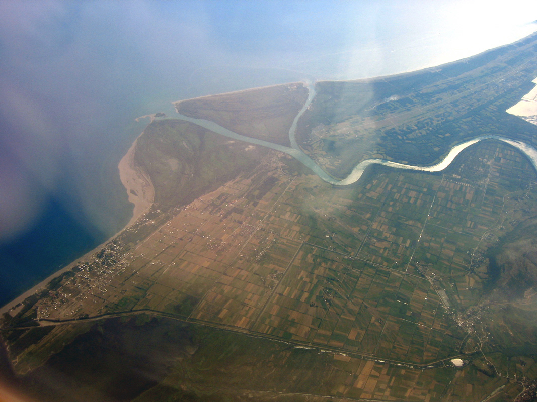
The river used to be longer, but due to a rise in the level of Lake Shkodër, the uppermost part of the river is now under the lake's surface. The river initially flows east, but after only few kilometers reaches the city of Shkodër and turns to the south. On the southern outskirts of the city, the river receives its most important tributary, the Great Drin, the greater part of which became its tributary after changing course during a flood in 1858 and now brings more water (352 m³/s) than the Buna itself (320 m³/s). After flowing around the Peak of Tarabosh, it passes through the villages of Zues, Bërdicë, Darragjat, Oblikë, Obot, Shirq, Dajç and Goricë.
Border river and the mouth
After 20 kilometres (12 mi) in Albania, it forms the border between Albania and Montenegro. On this border section, which is 24 km (15 mi) long, the river meanders widely, flowing around Lakes Šas and Zogajsko blato, both in Montenegro. Settlements include villages of Sveti Đorđe and Reč on the Montenegrin, and Luarzë and Pulaj on the Albanian side. The area surrounding the river in this section is low and marshy, the Bojana being the eastern border of the Field of Ulcinj and of the 12-kilometre-long (7.5 mi) Long Beach (Velika Plaža) of Ulcinj.
At its mouth into the Adriatic, Bojana forms a small delta with two arms, the left one forming the border with Albania, and the right one, with the island between the arms, being part of Montenegro. The island is called Ada Bojana (Ada, the Turkish word for "island", has found its way into the Serbian language). It was supposedly formed around a ship's wreck in the 19th century, and now covers an area of 6 km2 (2.3 sq mi), and is Montenegro's largest island. With the neighboring resort of Sveti Nikola ("Saint Nicholas"), it is a major center of nudism along the Adriatic.
The other, smaller island belongs to Albania and is called Franc Jozeph Island or Ada Major. This small island is not artificial such as Ada Bojana but natural. The Island of Franz Joseph frequently receives tourists.
Characteristics

The river has a large drainage basin of 5,187 km2 (2,003 sq mi). Lake Shkodër, the largest lake in southeastern Europe, at almost sea level, nearby empties into it, draining much of Montenegro. From Albania, and border lands east, its main tributary is the Great Drin. The Buna ranks second among all tributaries to the Adriatic (measured by average annual discharge) after the Po in Italy. Its mean discharge is c. 1,540 m3/s (54,000 cu ft/s).
It is highly navigable and is worked and toured by vessels ranging from motorboats, canal barges up to large tour boats and inland goods barges.
References
- "The coastline of Albania : morphology, evolution and coastal management issues" (PDF). ciesm.org. p. 8.
- "Lake Shkodra and River Buna". Ramsar Sites Information Service. Retrieved 25 April 2018.
- Demiraj, S. (2006). The Origin of the Albanians: Linguistically Investigated. Albanien: Academy of Sciences of Albania (p. 147)
- Ismajli, Rexhep (2015). Eqrem Basha (ed.). Studime për historinë e shqipes në kontekst ballkanik (p. 474)
- Katičić, Radoslav (1976). Ancient Languages of the Balkans. p. 186. ISBN 978-9027933058.
Bibliography
- Mala Prosvetina Enciklopedija, Third edition, Prosveta, 1985, ISBN 86-07-00001-2
- Jovan Đ. Marković, Enciklopedijski geografski leksikon Jugoslavije, Svjetlost-Sarajevo, 1990, ISBN 86-01-02651-6
Albania articles | |||||||||||||||||||||||||||||
|---|---|---|---|---|---|---|---|---|---|---|---|---|---|---|---|---|---|---|---|---|---|---|---|---|---|---|---|---|---|
| History |
|  | |||||||||||||||||||||||||||
| Geography |
| ||||||||||||||||||||||||||||
| Politics |
| ||||||||||||||||||||||||||||
| Economy |
| ||||||||||||||||||||||||||||
| Society |
| ||||||||||||||||||||||||||||
| |||||||||||||||||||||||||||||
| Town |
| ||||||||
|---|---|---|---|---|---|---|---|---|---|
| Villages |
| ||||||||
| Geography |
| ||||||||
| Landmarks |
| ||||||||
| Hotels |
| ||||||||
| Sports clubs |
| ||||||||
| Sports grounds | |||||||||
| Events |
| ||||||||
| Authority control: National libraries |
|---|
На других языках
[de] Buna (Adriatisches Meer)
Die Buna (albanisch auch Bunë; serbisch Бојана .mw-parser-output .Latn{font-family:"Akzidenz Grotesk","Arial","Avant Garde Gothic","Calibri","Futura","Geneva","Gill Sans","Helvetica","Lucida Grande","Lucida Sans Unicode","Lucida Grande","Stone Sans","Tahoma","Trebuchet","Univers","Verdana"}Bojana; lateinisch Barbana) ist der kurze Ausfluss aus dem Skutarisee ins Adriatische Meer. Auf rund zwei Drittel ihrer Länge von 44 Kilometern bildet die Buna die Grenze zwischen Albanien und Montenegro.- [en] Bojana (river)
[es] Río Bojana
El Río Bojana o Buna (Montenegrino:Bojana/Бојана; Albanés: Buna o Bune), es un río de 41 km de longitud que nace en el Lago Shkodër, atraviesa las fronteras de Albania y Montenegro y desemboca en el Mar Adriático. Es considerado como una continuación del Río Morača desde el Lago Skadar, lo que lo hace tener unos 183 km de longitud.[it] Boiana
Il fiume Boiana (in montenegrino: Бојана o Bojana; in albanese Buna) è un fiume lungo 41 km che segna, per gran parte della sua lunghezza, il confine tra il Montenegro e l'Albania.[ru] Буна (река)
Буна[1] (алб. Buna, Bunë) или Бояна[1] (черног. Бојана)— река на западе Балканского полуострова, протекает по территории Албании и Черногории и впадает в Адриатическое море.Другой контент может иметь иную лицензию. Перед использованием материалов сайта WikiSort.org внимательно изучите правила лицензирования конкретных элементов наполнения сайта.
WikiSort.org - проект по пересортировке и дополнению контента Википедии