geo.wikisort.org - River
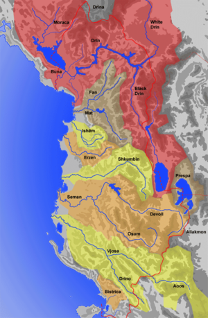
The Osum is a river in southern Albania, one of the source rivers of the Seman. It is 161 km (100 mi) long and its drainage basin is 2,073 km2 (800 sq mi). Its average discharge is 32.5 m3/s (1,150 cu ft/s).[1] Its source is in the southwestern part of the Korçë County, near the village Vithkuq at an altitude of 1,050 metres (3,440 ft). It flows initially south to the Kolonjë municipality, then west to Çepan, and northwest through Çorovodë where it flows through the famous Osum Canyon, Poliçan, Berat and Urë Vajgurore. It joins the Devoll near Kuçovë, to form the Seman. The discharge of the river is reported to vary between 5.11 m3 (180 cu ft)/s and 74.11 m3 (2,617 cu ft)/s.[citation needed]
| Osum | |
|---|---|
 | |
| Location | |
| Country | Albania |
| Physical characteristics | |
| Source | |
| • location | Western Vithkuq |
| • coordinates | 40°32′10″N 20°29′29″E |
| • elevation | 1,420 m (4,660 ft) |
| Mouth | |
• location | Seman near Kuçovë |
• coordinates | 40.8128°N 19.8588°E |
| Length | 161 km (100 mi) |
| Basin size | 2,073 km2 (800 sq mi) |
| Discharge | |
| • average | 32.5 m3/s (1,150 cu ft/s) |
| Basin features | |
| Progression | Seman→ Adriatic Sea |
Name
In classical antiquity, the Osum river was known as the Apsus, which is a derivative of the Indo-European root *ăp- "water, river". The contemporary Albanian name Osum (definite form: Osumi), which is used to indicate the upper course of the river, evolved from *Apsōn(em) through Bulgarian phonetic changes. In Bulgaria there is a river with the same name origin - Osam. Also the contemporary Albanian name Seman/Semen (definite form: Semani/Semeni), which is used to indicate the lower course of the river, evolved from *Apson-, but through Albanian phonetic changes.[2]
See also
 |
- Geography of Albania
- Rivers of Albania
References
- Cullaj, A., Hasko, A., Miho, A., Schanz, F., Brandl, H. & Bachofen, R. (2005). "The quality of Albanian natural waters and the human impact". Environment International. 31 (1): 138. doi:10.1016/j.envint.2004.06.008. PMID 15607787.
{{cite journal}}: CS1 maint: uses authors parameter (link) - Georgiev, Vladimir Ivanov (1981). Introduction to the History of the Indo-European Languages. Publishing House of the Bulgarian Academy of Sciences. p. 350. ISBN 978-953-51-7261-1.
This article about a specific location in Berat County, Albania, is a stub. You can help Wikipedia by expanding it. |
This article about a specific location in Korçë County, Albania, is a stub. You can help Wikipedia by expanding it. |
На других языках
[de] Osum
Der Osum (albanisch auch Osumi; lateinisch Apsus; griechisch Αψός .mw-parser-output .Latn{font-family:"Akzidenz Grotesk","Arial","Avant Garde Gothic","Calibri","Futura","Geneva","Gill Sans","Helvetica","Lucida Grande","Lucida Sans Unicode","Lucida Grande","Stone Sans","Tahoma","Trebuchet","Univers","Verdana"}Apsós[1]) ist ein 161 Kilometer langer Fluss in Südalbanien. Er entwässert ein Gebiet von 2073 Quadratkilometern, welches das zentrale südalbanische Bergland zwischen den Flüssen Vjosa und Devoll, die Westflanken des Grammosgebirges und des Tomorr umfasst.- [en] Osum
[es] Osum
El Osum es un río del sur de Albania, que forma el Seman al unirse con el Devoli. Tiene 161 km de largo y su cuenca abarca 2073 km². Su caudal medio es de 32,5 m³/s.[1] Nace en la parte suroeste del condado de Coriza, cerca del pueblo Vithkuq, a una altitud de 1050 m. Corre inicialmente hacia el sur hasta el municipio de Kolonjë, donde vira hacia el oeste hasta llegar a Çepan, lugar donde toma dirección noroeste; cruza luego Çorovodë (donde atraviesa el famoso cañón del Osum), Poliçan, Berat y Ura Vajgurore. Se une al Devoli cerca de Kuçovë y juntos forman un río nuevo, el Seman.[it] Osum
L'Osum è un fiume dell'Albania meridionale che origina, assieme al Devoll, il fiume Seman.[ru] Осуми (река)
О́суми[1][2][3] (алб. Osumi) — река в Албании. Сливаясь с рекой Деволи в области города Кучова в одноимённом округе в области Берат, образует реку Семани[4]. Берёт начало на западных склонах хребта Грамос[5]. Течёт в северо-западном направлении через каньон Осуми[en], мимо городов Чоровода и Берат. Длина реки 157 километров. Площадь водосбора около 2000 квадратных километров, средняя высота водосборного бассейна 828 метров над уровнем моря.Другой контент может иметь иную лицензию. Перед использованием материалов сайта WikiSort.org внимательно изучите правила лицензирования конкретных элементов наполнения сайта.
WikiSort.org - проект по пересортировке и дополнению контента Википедии