geo.wikisort.org - Reservoir
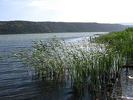
Lake Šas (Serbian: Шаско jезеро, romanized: Šasko jezero; Albanian: Liqeni i Shasit) is a lake located north-east of Ulcinj, near the village of Šas, in Montenegro. It is bordered geographically by Briska Gora (Mali i Brisë) to the southwest, Fraskanjelsko Polje (Këneta e Fraskanjellit) to the east, Ambulsko Brdo (Mali i Amullit) and Šasko Brdo (Mali i Shasit) to the northeast and the Brisko Polje (Fusha e Brisë) to the northwest. Geopolitically, Briska Gora lies to the southwest of Lake Šas, Fraskanjel lies to the east and Ambula and Šas to the northeast. The area of this lake is 5.5 km², it is 3.2 km long and 1.5 km wide. The max depth is 7.8 m. The shore of the lake is about 8.6 km.[1]
| Lake Šas Šasko Jezero / Шаско Језеро Liqeni i Shasit | |
|---|---|
 | |
 Lake Šas Šasko Jezero / Шаско Језеро Liqeni i Shasit | |
| Location | Ulcinj Municipality |
| Coordinates | 41.973°N 19.334°E |
| Primary outflows | Bojana |
| Basin countries | Montenegro |
| Max. length | 3.2 km (2.0 mi) |
| Max. width | 1.5 km (0.93 mi) |
| Surface area | 5.5 km2 (2.1 sq mi) |
| Max. depth | 7.8 m (26 ft) |
| Shore length1 | 8.6 km (5.3 mi) |
| 1 Shore length is not a well-defined measure. | |
It is also known as Little Lake Skadar because it has the same flora and fauna as Lake Skadar, which is much larger in size than Lake Šas. In warmer months, the lake is populated with large numbers of different bird species.
Fauna
List of bird species that have been found in Lake Šas:
- Pelecanus crispus
- Podiceps cristatus
- Tachybaptus ruficollis
- Microcarbo pygmeus
- Egretta garzetta
- Ardeola ralloides
- Platalea leucorodia
- Botaurus stellaris
- Anas platyrhynchos
- Larus cachinnans
- Sterna caspia
- Fulica atra
See also
- Lake Skadar
- Bojana (river)
- Ulcinj
References
- Jezera i rijeke, Montenegro Travel
На других языках
[de] Šasko jezero
Der Šasko jezero (albanisch Liqeni i Shasit) ist ein See im Süden Montenegros. Er liegt in der Gemeinde Ulcinj nahe der albanischen Grenze, eingeklemmt zwischen zwei Hügelzügen, die sich von Südosten nach Nordwesten erstrecken. Der See besitzt eine Fläche von 3,64 Quadratkilometer und ist maximal 7,8 Meter tief.[1] Entwässert wird er über einen rund ein Kilometer langen Kanal zur Buna.- [en] Lake Šas
[fr] Lac Šas
Le lac Šas est un lac monténégrin situé sur le territoire de la municipalité d'Ulcinj.[ru] Шаско
Шаско[1][2] (Ша́сское о́зеро) — ледниковое озеро в восточной части Черногории, второе по величине в стране после Скадарского озера. Названо по расположенному поблизости древнему городу Шас (Свач).Другой контент может иметь иную лицензию. Перед использованием материалов сайта WikiSort.org внимательно изучите правила лицензирования конкретных элементов наполнения сайта.
WikiSort.org - проект по пересортировке и дополнению контента Википедии