geo.wikisort.org - Mountains
The Šar Mountains (Serbian and Macedonian: Шар Планина, romanized: Šar Planina, colloquially also Шара Šara)[1] or Sharr Mountains (Albanian: Malet e Sharrit) is a mountain range extending from southern Kosovo[lower-alpha 1] to northwestern North Macedonia. The sections in Kosovo, and in North Macedonia are national parks.[2] Rugged and barren, the mountains are among the highest on the Balkans, with 30 peaks higher than 2,500 m (8,202 ft).
| Šar Mountains | |
|---|---|
| Sharr Mountains | |
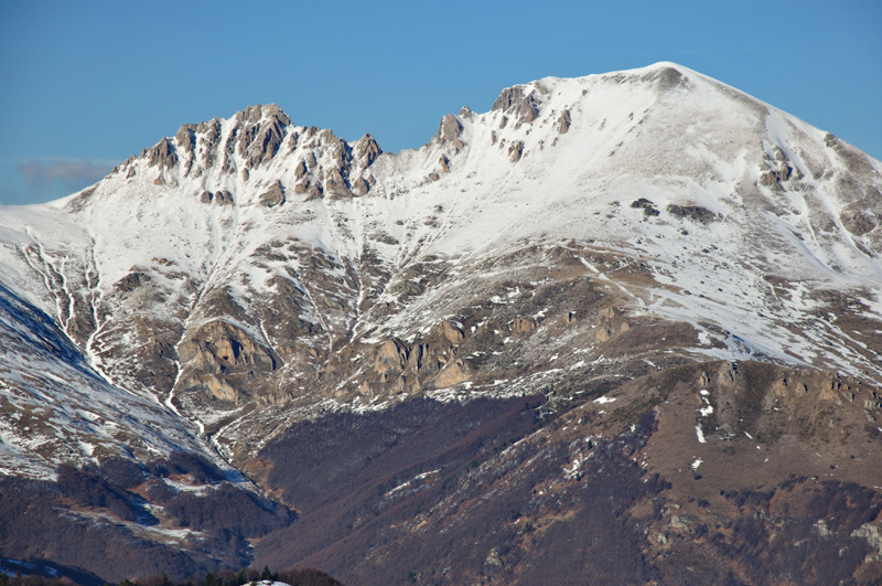
 Titov Vrv (back) and Small Turk (front), the tallest peaks of Šar Mountains | |
| Highest point | |
| Peak | Titov Vrv, North Macedonia |
| Elevation | 2,748 m (9,016 ft) |
| Geography | |
| Location | North Macedonia–Polog Valley Kosovo[lower-alpha 1]-District of Prizren |
Etymology
In antiquity, the mountains were known as Scardus, Scodrus, or Scordus (το Σκάρδον ὂρος in Polybius and Ptolemy).[3] which evolved into the modern name - "Sharr/Šar" - through sound development characteristic to the Albanian language from “Scardus”.[4] . In the early 16th century, it was recorded that the mountain was called Catena Mundi (Latin for "the chains of the world").[1]
Sometimes the range is called Carska Planina (Cyrillic: Царска Планина, "Tsar's Mountain"), as a reference to the capitals (Prizren and Skopje), courts (Nerodimlje, Pauni, Svrčin, etc.) and monasteries (monastery of the Holy Archangels) of the Serbian Empire located in the region.[5] In the medieval period, Serbs called the mountain Mlečni (Cyrillic: Млечани), because of the major milk production on the mountain and the vast herds of cattle, goats and sheep. In the golden bull issued by Emperor Dušan on 20 September 1349, he says: "I also bequest all of mine estates and areas around the Mlečni Mountain ("Milk Mountain"), the Durlev estates and all the metochions and all the wealth and treasure of that region". The bull is kept in the Dubrovnik Archive.[6]
Borders
The mountain borders extend from the city of Prizren, following the two rivers of the Prizren Lumbardhi and the Lepenac. In the east it passes by the town of Kaçanik through the Kaçanik Gorge and into North Macedonia via the Polog valley. The border passes near the Vardar spring called Vrutok and enters near the valley of Mavrovo. There the Radika river separates the mountain massif from the higher Mount Korab. After that, the border is mounting, reaching the point of junction of three state borders: Kosovo, North Macedonia and Albania. The border now follows the road to the small, mountainous, town of Restelica, the rivers of Globocica, Plava and the White Drin and finally reaches the city of Prizren.
Geographical characteristics


The Šar Mountains have a total area of 1600 km². 56,25% of that area is in North Macedonia, 43.12% in Kosovo, and 0,63% in Albania.[7][better source needed] There are three plains Sirinić, Vraca and Rudoka.[8] The system is about 80 km (50 mi) long and 10–20 km (6–12 mi) wide.
The mountain massif was formed in the Tertiary Period. The peaks are covered with ice and snow.
It includes several high peaks:
- Titov Vrv (2,747 m or 9,012 ft)
- Mal Turčin (2,707 m or 8,881 ft)
- Bakardan (2,704 m or 8,871 ft)
- Borislavec (2,675 m or 8,776 ft)
- Great Rudoka (2,658 m or 8,720 ft)
- Bistra - east summit (Peskovi) (2,651 m or 8,698 ft)
- Bistra - west summit (2,641 m or 8,665 ft)
- Small Rudoka (2,629 m or 8,625 ft)
- Džini Beg (2,610 m or 8,563 ft)
- Lake Peak (2,604 m or 8,543 ft)
- Karabunar (2,600 m or 8,530 ft)
- White Lake Peak (2,590 m or 8,497 ft)
- Maja e zezë (2,585 m or 8,481 ft)
- Big Vraca (2,582 m or 8,471 ft)
- Guzhbaba (2,582 m or 8,471 ft)
- Isa Aga (2,555 m or 8,383 ft)
- Black Peak (2,536 m or 8,320 ft)
- Kobilica (2,528 m or 8,294 ft)
- Piribeg (2,524 m or 8,281 ft)
- Ljuboten (2,498 m or 8,196 ft)
- Maja Livadh (2,497 m or 8,192 ft)
- Zallina (2,493 m or 8,179 ft)
- Small Vraca (2,483 m or 8,146 ft) 41.8861°N 20.7375°E
- Kara Nikolla (2,409 m or 7,904 ft) 42.0836°N 20.7942°E
- Maja Koritnik (2,393 m or 7,851 ft)
- Tumba Peak (2,346 m or 7,697 ft)
- Gemitash (2,183 m or 7,162 ft) 41.9075°N 20.6808°E
- Kalabak (2,174 m or 7,133 ft) 41.918°N 20.576°E[9]
- Crnkamenska Kula (2,117 m or 6,946 ft) 41.9006°N 20.6639°E
- Šerupa (2,092 m or 6,864 ft) tri-point 41.877°N 20.595°E
There are 30 peaks higher than 2,500 m (8,200 ft) and 70 above the 2,000 m (6,600 ft).[1]
The Šar Mountains extend to Mount Korab (2,764 m or 9,068 ft) in the southwest, and pass into northeastern Albania with very small part (0.63% of the entire length).
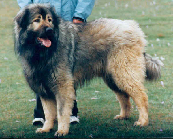
Vegetation on the mountains includes crops up to around 1,000 m (3,281 ft), forests up to 1,700 m (5,577 ft), and above that lie high pastures which encompass around 550 km2 (212 sq mi). The Šar Mountains are the largest compact area covered with pastures on the European continent. The dog breed Šarplaninac comes from this area.
The snowy peaks of the Šar Mountains are depicted on the coat of arms of the city of Skopje, which in turn is incorporated in the city's flag.[10]
History
The remains of the Široko complex are located near Mušutište. The complex originates from the period between the 10th and the 7th century BC, but also has medieval remnants. In Roman period, the mountain was a tripoint between the provinces of Dalmatia, Moesia and Macedonia. The route of an ancient road crossed the Scardus from 169 BC. The road was later named Velji ("Great") or Prizren road. Lisinski road was built. Remnants of the fort on the Kradište hill, near Prizren, dates from the 2nd to the 6th century and testifies the change of civilizations in this region: it started in the pre-Roman period, then became a Roman town and later a Byzantine one. Locality of Ravna Gora, predating the 6th century, where Slavs later cremated their dead, is situated in the area. Medieval military complex of Petrič Fortress, which consists of two fortresses, Little Petrič and Great Petrič, is also preserved. Remains of the Višegrad Fort, older part of the Prizren Fortress, are located in the gorge of the Bistrica river. When King Milutin donated lands to the Our Lady of Ljeviš church, he also donated the Višegrad Fort to serve as an Prizren's defence outpost. Emperor Dušan later expanded the fort to the river and built his endowment, the Monastery of the Holy Archangels.[1]
There are 45 Serbian Orthodox monasteries on the slopes of the mountain, dating from the 12th to the 16th century. Additional 32 monasteries were damaged or demolished during the NATO bombing of Serbia in 1999 and in the later years. Church of the Dormition of the Mother of God in the village of Gotovuša in Sirinićka Župa was built in 16th century. It was destroyed later and rebuilt in the second half of the 19th century. During the works in churchyard in the 2010s a floor mosaic was discovered from the much older church from the Byzantine period.[1]
Šar Mountains in Kosovo


The Šar Mountains are located in the south and south-east of Kosovo, where 43.12% of the range is located. Many alpine and glacial mountain lakes are found on the Kosovar part of the Šar Mountains, especially south of the village of Dragaš, the area of Shutman and the region north of Vraca. The Brezovica ski resort, with an elevation of 900 m (2,953 ft) to 2,524 m (8,281 ft) above sea level, is located north-east of the mountains.
The mountain range in Kosovo is divided into three main zones:The zone of Ljuboten and Brezovica, the central zone of Prizren and the zone of Opoja and Gora.
The mountains border the Kosovo Plain to the north-east and the Metohia Valley in the northwest. Kosovo consists of the most eastern tip and the most northern part of the mountain ridge.
This article may be confusing or unclear to readers. (September 2016) |
The Ljuboten peak and the mountain of Skopska Crna Gora create the Kačanik Gorge in Kosovo. The Šar Mountains are split from the Nerodimka Mountain by the Sirinić Valley. The Šar National Park is located in Kosovo. Villages and towns that are found near the mountain are:
- Prizren largest city located at the foot of the mountains.
- Kaçanik
- Dragaš
- Brezovica
- Štrpce
Lakes in the Kosovo part of the Šar Mountains are:
- Big Jažinačko Lake
- Small Jažinačko Lake
- Šutmansko Lake
- Lower Defsko Lake
- Štrbačko Lake
- Black Vir Lake
- Donji Vir Lake
- Blateško Lake
- Upper Defsko Lake
- Dinivodno Lake
In total, there are 70 glacial lakes on Šara.[1]
Kosovo national park
| Sharr Mountains National Park | |
|---|---|
IUCN category II (national park) | |
 | |
| Area | 534.69 km2 (206.44 sq mi) |
| Established | 1986 |
History
Sharr Mountains National Park is in the territory of Kosovo and covers 534.69 km2 (206 sq mi) on the northern slopes of the Šar Mountains as well as the mountains of Ošljak and Jezerce. The National Park "Šar-Planina Mt." was proclaimed in 1986 within the temporary boundaries of 390.00 km2 (150.58 sq mi),[11][12][13] and opened in 1995.[14] The final boundaries of the Park were expanded in 2012 to cover an area of 534.69 km2 (206.44 sq mi).
Geography
The park occupies the northwest sections of the mountain's main massif, including the highest peak, Bistra, an spreads over the sections of Prevalac, Ošljak, Ostrovica and Kodža Balkan. The park encompasses several different types of topographic relief: glacial (cirques, moraines and glacial lakes), periglacial (snow cirques, sliding blocks, "tundra mosaic" type of micro-shapes in the deposits of silt), karstic and fluvial. There are numerous rivers, springs, creeks, bogs and lakes.[13]
Plant life
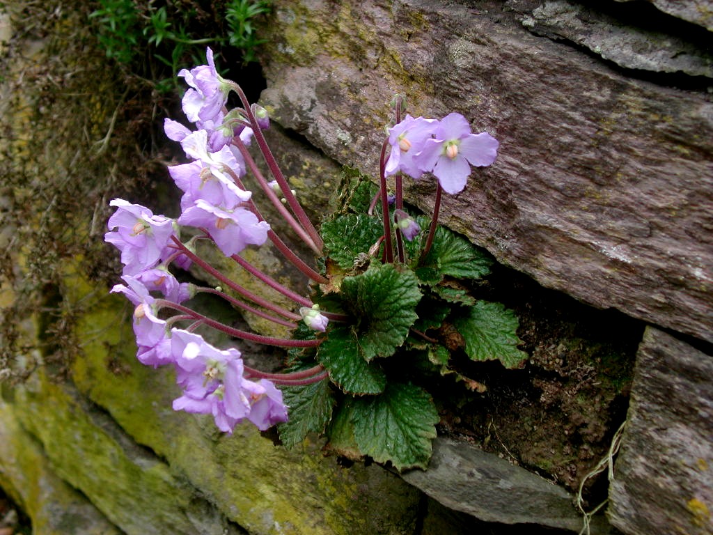
In total, there are 1,800 plant species. The mountain is inhabited by 175 strictly protected plant species, 247 Balkan endemites and 18 plants which can be found only on Šara.[1] The park includes the endemic relict Macedonian Pine[13] and white-bark pine,[13] as well as the mugo pine[13] and Alpine rose. Other perennial plants include King Alexander's yarrow (Achillea alexandri-regis), Nikolić's silene (Heliosperma nikolicii), Bornmuellera dieckii, Šar carnation (Dianthus scardicus Wettst.),[13] Doerfler's cinquefoils and Macedonian meadow saffron (Colhicum macedonicum). One of the relic species is Natalie's ramonda. It went extinct from the most of Europe during the last ice age and today grows as an endemic species in several gorges in Serbia, North Macedonia and Greece. It has been chosen as the Serbian symbol for the Armistice Day.[1]
Animal life
Rusenica locality on the mountain has been in the first level of protection, as the strict reserve of nature, since 1955. It is one of the rare habitats of Balkan lynx, the largest European cat. It is estimated that on the entire Balkans there are no more than 100 specimens. European pond turtle and Hermann's tortoise, only two European species of freshwater turtles, live on the mountain. There are 147 butterfly species (excluding moths), 45 amphibians and reptilians and 37 mammalian species.[1] Other animals include bear, chamois, wolf, roe deer, wild boar and other species including many bird species. The national park contains 720 chamois while the Opoja and Gora region contains 600 chamois. The National Park is administrated by the Ministry of Environment and Spatial Planning (MESP) of Kosovo.
See also
Annotations
- The political status of Kosovo is disputed. Having unilaterally declared independence from Serbia in 2008, Kosovo is formally recognised as an independent state by 100 UN member states (with another 13 states recognising it at some point but then withdrawing their recognition) and 93 states not recognizing it, while Serbia continues to claim it as part of its own sovereign territory.
References
- Dimitrije Bukvić (31 July 2017), "Trezor Evrope", Politika (in Serbian), pp. 01 & 09
- "СОБРАНИЕТО ГО УСВОИ ЗАКОНОТ СО КОЈ ШАР ПЛАНИНА СТАНУВА НАЦИОНАЛЕН ПАРК". Сакам Да Кажам (in Macedonian). 2021-06-30. Retrieved 2021-06-30.
- Sir William Smith (1872). Dictionary of Greek and Roman Geography: Isabadius-Zymethus. 1857. John Murray. p. 928.
- Katičić, Radoslav (1976). Ancient Languages of the Balkans. Mouton. p. 186. ISBN 9789027933157.
On the other hand Niš from Ναϊσσός, Štip from Ἄστιβος, Šar from Scardus, and Ohrid from Lychnidus presuppose the sound development characteristic for Albanian.
- Veselinović, Andrija; Radoš Ljušić (2001). Srpske dinastije (in Serbian). Novi Sad. ISBN 86-83639-01-0.
- "Да ли знате? - Како се некад звала Шар-планина" [Do you know? - How the Šar Mountains used to be called]. Politika (in Serbian). 6 June 2018. p. 30.
- Rista Nikolić (1912). Glacijacija Šar Planine i Koraba (in Serbian). Beograd.
- Živko Stefanovski. Šar Planina (in Macedonian). Tetovo: Napredok.
- "National Park Šar-Mountain". brezovica-ski.com.
- Official portal of the city of Skopje: City symbols. – Retrieved on 13 May 2009.
- Zeqir, Veselaj (1 January 2013). "Extension of national park "Sharri" boundaries and its significance for nature conservation in Kosovo". Natura Montenegrina. 12: 607–616. Retrieved 10 April 2018 – via ResearchGate.
- "Zakon o nacionalnim parkovima (National parks law)" (in Serbian). 5 October 2015.
- Aleksandra Mijalković (18 June 2017), "O očuvanju naše prirodne baštine: najbolja zaštita u naconalnim parkovima", Politika-Magazin (in Serbian), pp. 3–6
- Ministry of Environment and Spatial Planning(in Albanian)
External links
 Media related to Šar Mountains at Wikimedia Commons
- Šar planina (in Serbian)
Kosovo articles | |||||||||
|---|---|---|---|---|---|---|---|---|---|
| History |
|  | |||||||
| Geography |
| ||||||||
| Politics |
| ||||||||
| Economy |
| ||||||||
| Society |
| ||||||||
| |||||||||
Authority control | |
|---|---|
| General |
|
| National libraries | |
На других языках
[de] Šar Planina
Die Šar Planina (mazedonisch und serbisch Шар планина Šar planina, albanisch Malet e Sharrit, auch Mali i Sharrit oder Sharr) ist ein Gebirgszug, der sich zwischen dem Kosovo und Nordmazedonien erstreckt, der Titov Vrv ist mit 2747 m. i. J. der höchste Punkt.- [en] Šar Mountains
[es] Montes Šar
Los montes Šar (serbio y macedonio Шар Планина, Šar Planina; albanés Malet e Sharrit, Sharr) es una cadena de montañas situada en la frontera sur de Serbia y en la parte noroeste de Macedonia del Norte.[fr] Monts Šar
Les monts Šar sont une chaîne montagneuse qui s'étend du sud du Kosovo[1] au nord-ouest de la Macédoine du Nord.[it] Monti Šar
I Monti Šar (Шар Планина in macedone e Malet e Sharrit in albanese) sono un sistema montuoso situato al confine tra il Kosovo, l’Albania e la parte nordoccidentale della Macedonia del Nord.[ru] Шар-Планина
Шар-Пла́нина (макед. Шар Планина, серб. Шар-планина / Šar-planina, алб. Malet e Sharrit — «пёстрая гора»), или разговорное Шара (макед. Шара, серб. Шара / Šara), или Шар-Даг (тур. Şar Dağ) — горный хребет на Балканском полуострове. Основная часть находится на территории Северной Македонии и Косова, небольшая часть — в Албании. Простирается с северо-востока на юго-запад на 75 км. Высочайшие пики — Титов-Врх (2748 м[2]) и Турчин (2702 м). В южной части горная система продолжается хребтами Кораби (2764 м), Бистра (2163 м), Ябланица (2257 м) и Галичица (2254 м) суммарной протяжённостью 160 км[3].Другой контент может иметь иную лицензию. Перед использованием материалов сайта WikiSort.org внимательно изучите правила лицензирования конкретных элементов наполнения сайта.
WikiSort.org - проект по пересортировке и дополнению контента Википедии