geo.wikisort.org - Mountains
Goč[1][2] (Serbian Cyrillic: Гоч) is a mountainous area in central Serbia, about 15 km south of the spa town of Vrnjačka Banja. Its highest peak Ljukten (Serbian Cyrillic: Љуктен) has an elevation of 1,216 m (3,990 ft) above sea level.
| Goč | |
|---|---|
 | |
| Highest point | |
| Elevation | 1,216 m (3,990 ft)[1] |
| Coordinates | 43°32′11″N 20°50′44″E |
| Geography | |
 Goč Location in Serbia | |
| Location | Central Serbia |
Goč is a popular hiking and mountaineering destination and the village Goč is a small ski resort. The skiing area is equipped with a single-seater ski lift and the longest slope is 1,500 m long and 40 m wide.[3] The skiing area is located on the mountain Krst (Serbian Cyrillic: Крст) with an elevation of 1,123 m (3,684 ft). The artificial lake Selište is located in the area as well.
Gallery
 Lake Selište
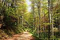 Deciduous forest road
 Hiking on Goč mountain in winter
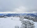 Panoramic view from top of Goč in winter
 Cottage close to evergreen forest
 Evergreen forest in winter
 Lake Selište in fall
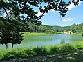 Lake Selište in summer


See also
- List of mountains in Serbia
- Article about the village Goč (in Serbian)
References
- Jovan Đokić. "Katalog planina Srbije". PSD Kopaonik Beograd. Archived from the original on 2011-05-18.
- Planine opštine Kraljevo (in Serbian), Kraljevo.com, retrieved 2010-10-11
- Ski staze (in Serbian), Smučarski klub Goč, retrieved 2010-10-13
Wikimedia Commons has media related to Goč.
External links
| Settlements |  | |
|---|---|---|
| Landmarks |
| |
| Culture |
| |
| Notable people | ||
This Serbia location article is a stub. You can help Wikipedia by expanding it. |
На других языках
- [en] Goč
[fr] Goč (montagne)
Le mont Goč (en serbe cyrillique : Гоч) est une montagne du centre-sud de la Serbie. Son point culminant, le pic de Krnja jela, s'élève à une altitude de 1 127 m. Il se trouve au nord de l'ensemble montagneux du Kopaonik.Текст в блоке "Читать" взят с сайта "Википедия" и доступен по лицензии Creative Commons Attribution-ShareAlike; в отдельных случаях могут действовать дополнительные условия.
Другой контент может иметь иную лицензию. Перед использованием материалов сайта WikiSort.org внимательно изучите правила лицензирования конкретных элементов наполнения сайта.
Другой контент может иметь иную лицензию. Перед использованием материалов сайта WikiSort.org внимательно изучите правила лицензирования конкретных элементов наполнения сайта.
2019-2026
WikiSort.org - проект по пересортировке и дополнению контента Википедии
WikiSort.org - проект по пересортировке и дополнению контента Википедии