geo.wikisort.org - Mountains
Fruška gora (Serbian Cyrillic: Фрушка гора; Hungarian: Tarcal-hegység) is a mountain in Syrmia, administratively part of Serbia with a part of its western side extending into eastern Croatia. The area under Serbian administration forms the country's oldest national park. Sometimes also referred to as the Jewel of Serbia, due to its largely pristine landscape and protection effort, or the Serbian Mount Athos, being the home of a large number of historical Serbian Orthodox monasteries.
| Fruška gora | |
|---|---|
| Фрушка гора | |
 | |
| Highest point | |
| Elevation | 539 m (1,768 ft)[1] |
| Coordinates | 45°09′04″N 19°42′40″E |
| Naming | |
| Nickname | Serbian Mount Athos |
| Geography | |
 Fruška gora Location in Serbia (map including Kosovo*) | |
| Location | Syrmia |
| Parent range | Pannonian island mountains |
| Geology | |
| Mountain type | Island mountain |
IUCN category II (national park) | |
 Fruška Gora National Park | |
| Area | 266.72 km2 (102.98 sq mi) |
| Established | 1960 |
Name
In Serbian, it is known as Fruška gora (pronounced [frûʃkaː ɡǒra], Фрушка гора), in Hungarian as Tarcal (also Almus-hegy or Árpatarló), in German as Frankenwald, and in Latin as Alma Mons. In Medieval Greek, it was known as Frangochoria.
The mountain's name originates in the old Serbian word "Fruzi" derived from the singular form "Frug"; and its adjective is Fruški, used for naming the Frankish people.[2] The name of "Fruška Gora" is "Frankish mountain" in English whose meaning is based on describing a historical event. The mountain served as a natural border when Frankish campaigns were set up in the area. In the time of the Roman Empire, its name was Alma Mons, meaning the "fertile mount". It is recorded that during the reign of emperor Marcus Aurelius Probus, 276-282, who was born in the nearby Sirmium, the first grapevines on the mountain were planted.[2]
Geography
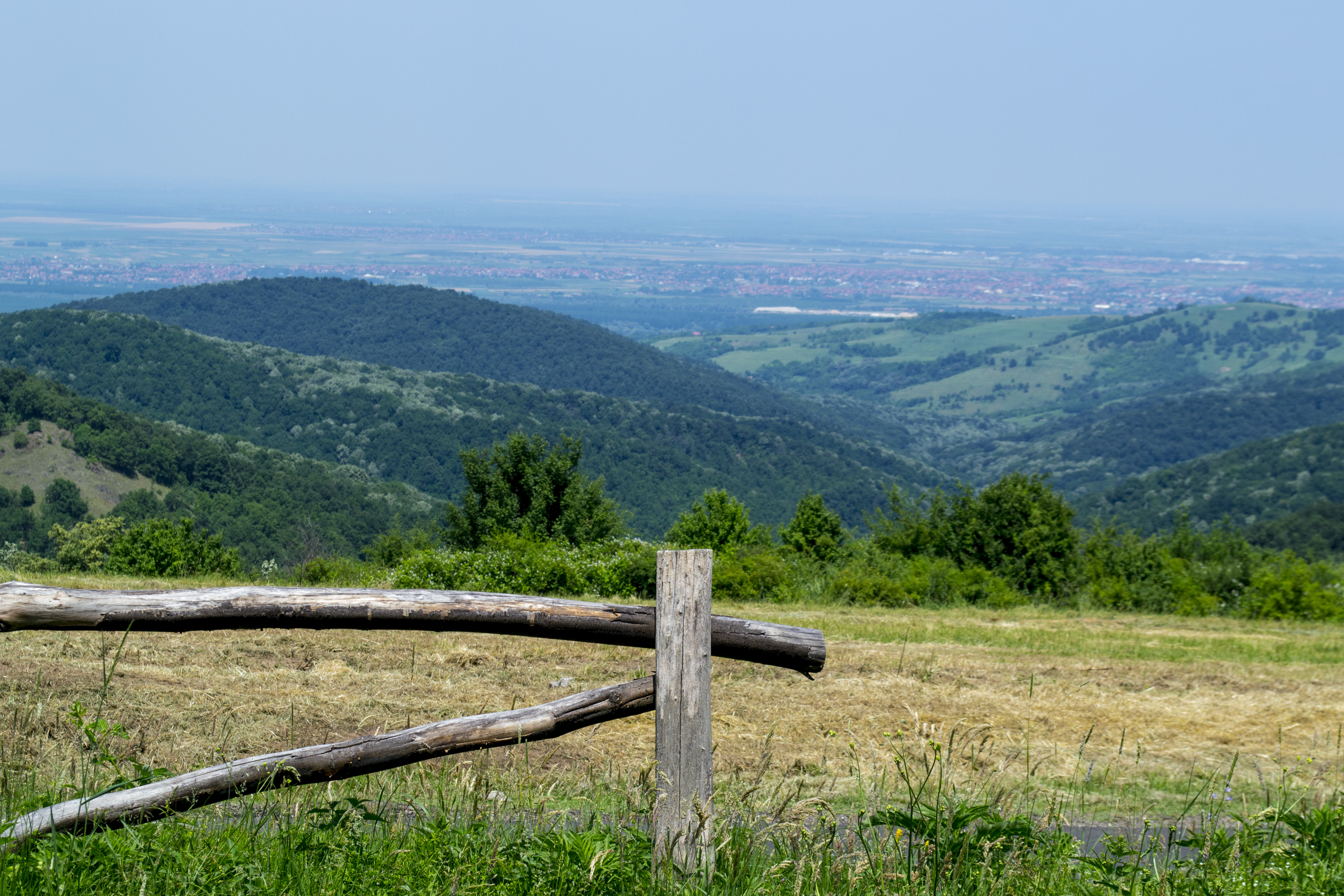
The mountain is a natural geological phenomenon as it is built from rocks from almost all geological periods.[3] It used to be an island during the existence of the Pannonian Sea. To the north, the mountain is bordered by the Danube river, while to the south it descends into the Syrmian lowlands. It is stretching approximately 80 km (50 mi) from east to west and 15 km (9.3 mi) from north to south. Its highest peak is Crveni Čot at 539 m (1,768 ft).[2]
Vineyards
Fruška Gora also divides Syrmia in two geographically distinct parts: Wine Syrmia (upper or mountainous) and Swine Syrmia (lower or lowland). Slopes of the mountain were established as one of the most prestigious vineyards in Hungary, ever since the 15th century. Golden age of the Fruška Gora's viticulture began after 1699 and the Treaty of Karlowitz, when Ottomans were expelled from the area, until the late 19th century.
In Sremski Karlovci, a famous dessert wine called bermet is produced, with protected geographical indication. It is recorded that the crates of bermet were used as a bribe by the Serbs to obtain certain privileges from the Austrian empress Maria Theresa. The wine was served at the Russian and British courts, and was on the wine list of Titanic.[2]
The slopes of Fruška Gora are perfectly suited for grape arbors, and wine-makers producing Traminer, Riesling and other wines in the region. After the fall of communism, the Serbian Orthodox Church got 10,000 hectares restitution in the area of their nationalized properties.[4]
National park
The national park of Fruška Gora was declared in 1960 and covers an area of 266.72 km2 (102.98 sq mi). It is the oldest modern national park in Serbia.[2]
Plant life
Rich fossil fauna is preserved and almost 90% of the park area is forested. The predominant tree species include linden, oak and beech.[2] The concentration of linden forests is highest in Europe. In time, linden became the dominant tree species, replacing formerly much larger and dominant oak forests, which are considered to be the autochthonous vegetation on Fruška Gora.[5] Altogether, 1,500 plant species inhabits the park, of which 200 are protected.[3] There are also 400 species of fungi. Pannonian plant endemites include Tatar dock (Crambe tataria), broadleaf wild leek and Hungarian leopard's-bane. There are some 30 species of orchids in the park.[2]
In 2016, massive cutting of trees in the park occurred, one of the largest in the mountain's recorded history. Over 10 ha (25 acres) of forest have been cut. Park administration then stated that an autochthonous species of oak will be planted instead. However, they never planted anything and in the future years a thicket of the remaining black locust high shrubs grew instead. The administration, nevertheless, claims that the oaks have been planted. In the spring of 2019, aggressive cutting continued. Apparently indiscriminate cutting, without proper notifications what is being cut and by whom, destroyed hiking paths and orienteering marks. Also, the cutting sections of the forest weren't properly secured and some were completely wrong: beech trees have been cut even though the table stated that oak trees are being cut. According to the environmentalists, regular visitors and recreational athletes, the cutting was never so massive.[6][7][8]
Timber was transported outside of the park and was sold by the park administration. They responded that everything is being part of the planned action, that park has to think about the "economic part" of its existence (as the government is allocating small amounts of money to the park) and that trees will be "replenished later" because the cut ones were old. Members of the commission which participated in the planning said that even more trees should have been cut as 80% of the forest is over 80 years old. Only 3% of park's territory is under the strict protection (some 800 ha (2,000 acres) of forest at Papratski Dol locality). The trees have been cut right along the border of this area, clearing the land which surrounds it. Citizens responded that national park is not a tree farm where the trees should be "replaced" and that protected forests can't be perceived as a feedstock. Director of the park said that he doesn't know how much trees they cut and planted, but numbers officially published by the park in 2018 show that in an undefined period they planted 50,000 seedlings, but 100,000 trees have been cut. Also, the park's plan for 2019 envisioned almost 100 time more money for cutting the trees than for the planting of the new ones.[6][7][8] In 2020, 60,000 new trees were planned to be planted in the park, to commemorate 60th anniversary of the national park establishment.[9]
By the 2010s, the predominant cultivated plant on the foothills of the mountain and the surrounding vast fields, became the rapeseed.[5] In March 2020 it was announced that saffron was discovered on the mountain. There are some 20 species of saffron living in Serbia, but they never populated Fruška Gora. The discovered species is woodland crocus, it was found on only one location, but already spread to several thousand individual plants.[10]
With several other beech localities in the national parks of Tara and Kopaonik, beech forests Papratski Do and Ravne on Fruška Gora have been submitted for the inclusion into the UNESCO World Heritage Site Ancient and Primeval Beech Forests of the Carpathians and Other Regions of Europe in May 2020. The nomination was rejected due to the Serbian laws allowing shelterwood cutting on the area of 5 hectares (12 acres), while UNESCO accepts cut areas no larger than 1 hectare (2.5 acres), and even that is not only in the areas of the highest level of protection, but also in the surrounding zones. It was announced that the rules will be changed, so that parts of Fruška Gora might be included in 2023.[11]
Animal life
Protected insect species include Balkan goldenring, certain species of dragonflies and hoverflies, and Hungarian ground beetle, which already went extinct in some other European countries.[2] Park is also the habitat of 13 amphibian species and 11 reptilians, of which 14 are protected, among them fire salamander and European adder.[3]
Park is home to 211 bird species. Symbol of Fruška Gora is eastern imperial eagle, today with only 2 or 3 remaining breeding couples. There are 60 mammalian species, of which 17 are protected, including edible dormouse, European pine marten, European polecat and Mediterranean water shrew.[2] Out of 30 species of bats which live in Serbia, 15 inhabits the mountain and all are under strict protection.[12]
In January 2018, for the first time after the 1960s, additional mouflons were introduced in the park. 30 animals were relocated from Slovakia, which raised the number of mouflons in the park to 70.[13] European fallow deer was also reintroduced. On 29 March 2022, five European bisons were reintroduced in the previously prepared habitat on the mountain. One bull and four cows were transported from the Poland's Białowieża Forest reserve. It is estimated that the last bison on Serbian territory was hunted in c.1800.[14]
History

There are traces of human habitation in this area that date from neolithic times. Before the Roman conquest, Illyrians and Celts[2] inhabited this region. In 31 AD, this area was conquered by the Romans and was included into Pannonia province. The Danube river was a border of the Roman Empire (limes), and on the northern side of the mountain several Roman border fortresses were built.
In the Early Middle Ages, this area was settled by Quadi, Huns, Goths, Gepids, Slavs and Avars. The Franks expelled Huns, Avars, Gepids and Lombards from this area and formed the southern border of the Frankish Empire, ultimately giving its name to the mountain.[2]
It was later inhabited by Bulgarians, Pechenegs and Hungarians. In the 11th century, when Christianity was split between Catholicism and Orthodoxy, both communities had their churches in this region. A very important group of Serb medieval monasteries was formed on the mountain.[15]

Since the 19th century, during the Austro-Hungarian period, cities developed so as the trade and crafts. Settlements on the mountain itself developed, designed in the typical folk tradition. Two most distinct settlements, in terms of architectural inheritance, are Sremski Karlovci, which grew into the center of the political and cultural life of the Serbs in Austria and, later, Austria-Hungary, and Irig, one of the most developed Syrmian settlements since the 18th century.[16]
Over the time, the area was part of the Hun Empire, the Ostrogothic Kingdom, the Gepid Kingdom, the Lombard state, the Byzantine Empire, the Avar Khaganate, the Frankish Empire, the Bulgarian Empire, Lower Pannonia, the Kingdom of Hungary, the Ottoman Empire, the Habsburg monarchy, the Austrian Empire, Austria-Hungary, the State of Slovenes, Croats and Serbs, the Kingdom of Serbia, the Kingdom of Serbs, Croats and Slovenes, the Kingdom of Yugoslavia, Socialist Federal Republic of Yugoslavia, Serbia and Montenegro, and now is within the Republic of Serbia.[17]
During World War II, this area was occupied by the Axis Powers, and Fruška Gora was an important center of Partisan resistance movement. A liberated partisan territory was formed in this region.[18]
On 28 March 2003, police revealed that former Serbian president Ivan Stambolić had been assassinated by eight men on the mountain. At the time Slobodan Milošević was still in power. It was later determined that Milošević had given the order for Stambolić's murder.[19][20]
Archaeology
Edreš Hill was used as a quarry by the prehistoric people for their tools. There are numerous Roman remains, like the fortress Acumincum near Slankamen and Bassianae, a Roman town near Donji Petrovci. The town was fortified with the ramparts and square towers. Within the walls, the objects with the heating and sewage systems were discovered, so as the walls painted with frescoes and floor mosaics. In 1952, in the locality of Bikić Do, a Roman vault was discovered with 11,500 coins, including ones from the reign of Constantine the Great.[2]
Attractions from the later period include the Tower of Vrdnik, the only remaining part of the medieval fortress, the Rivica Watermill and Stražilovo, where the remains of the poet Branko Radičević were reinterred from Vienna in 1883.[2]
Population and settlements
In 1991, the population of the Fruška Gora region numbered at 114,263 people. Settlements in the area include 23 villages, as well as several towns, which are located around the mountain. These towns are: Šid, Beočin, Petrovaradin, Sremska Kamenica, Sremski Karlovci and Irig.
Monasteries


There are over a dozen Serbian Orthodox monasteries located on Fruška Gora. In the eighteenth century the monasteries became the home of monks from Rača monastery in the Bajina Bašta municipality by the Drina River. These monks were writers famous for their illuminated manuscripts.
The Fruška Gora Monasteries were declared Monuments of Culture of Exceptional Importance in 1990, and are protected by the state.
Ottoman documents mention 35 monasteries, of which 16 survived and are still active today. Due to such a large number of monasteries on one place, Fruška Gora is colloquially called Serbian Mount Athos.[2] The Holy Synod of the Serbian Orthodox Church officially declared Fruška Gora a Holy Mountain on 12 October 2003.[21]
List of monasteries:
- Beočin – The time of founding is still unknown. It is first mentioned in Turkish records dated in 1566/1567.
- Bešenovo – According to the legend, the Bešenovo monastery was founded by Serbian King Dragutin at the end of the 13th century. The earliest historical records about the monastery that can be found date from 1545.
- Divša – It is believed to have been founded by Despot Jovan Branković in the late 15th century. The earliest historical records about the monastery date to the second half of the 16th century.
- Grgeteg – According to tradition the monastery was founded by Zmaj Ognjeni Vuk (Despot Vuk Grgurević) in 1471. The earliest historical records about the monastery that can be found date to 1545/1546. Icons were painted by Uroš Predić.[2]
- Jazak – The monastery was founded in 1736.
- Krušedol – The monastery was founded between 1509 and 1516, by Bishop Maksim (Despot Đorđe Branković) and his mother Angelina. Resting place of king Milan I of Serbia.[2]
- Kuveždin – Traditionally, its foundation is ascribed to Stefan Štiljanović. The first reliable records of it are dated in 1566/1569.
- Mala Remeta – The foundation is traditionally ascribed to the Serbian King Dragutin. The earliest historical records relating to the monastery are dated to the middle of the 16th century.
- Novo Hopovo – According to tradition, the monastery was built by the Despots of the Branković dynasty. The first reliable mention of the monastery is dated to 1641. Dositej Obradović became a monk in this monastery.[2]
- Privina Glava – According to the legends, Privina Glava was founded by a man named Priva, in the 12th century. The earliest historical records about the monastery are dated in 1566/1567.
- Petkovica – According to the tradition, it was founded by the widow of Stefan Štiljanović, Despotess Jelena. The earliest historical records mentioning the monastery are dated to 1566/1567.
- Rakovac – According to a legend written in 1704, Rakovac was founded by a certain man, Raka, courtier of Despot Jovan Branković. The legend states that Raka erected the monastery in 1498. The earliest historical records mentioning the monastery are dated to 1545/1546.
- Staro Hopovo – According to the tradition, the monastery was founded by Bishop Maksim (Despot Đorđe Branković). The first reliable mention of the monastery dates back to 1545/1546.
- Šišatovac – The foundation of the monastery is ascribed to the refugee monks from the Serbian monastery of Žiča. The reliable facts illustrating the life of the monastery date back from the mid 16th century.
- Velika Remeta – Traditionally, its founding is linked to King Dragutin at the end of the 13th century. The earliest historical records about the monastery date to 1562.
- Vrdnik-Ravanica – The exact date of its founding is unknown. The records indicate that the church was built at the time of Metropolitan Serafim Jovanović, in the second half of the 16th century. It holds the reliquary of Prince Lazar and his partial relics.[2]
Gallery
|


See also
- Fruškogorski maraton
- Lake Ledinci
- Pannonian Island Mountains
- List of mountains in Serbia
- Spatial Cultural-Historical Units of Great Importance
References
- Jovan Đokić. "Katalog planina Srbije". PSD Kopaonik Beograd. Archived from the original on 18 May 2011.
- Dimitrije Bukvić (24 July 2017), "Pod krilima orla krstaša", Politika (in Serbian), pp. 1, 8
- Aleksandra Mijalković (18 June 2017), "O očuvanju naše prirodne baštine: najbolja zaštita u naconalnim parkovima", Politika-Magazin (in Serbian), pp. 3–6
- Crkva neće novac za šume Archived 28 December 2008 at the Wayback Machine
- D.S. (17 May 2020). Занимљива Србија: Војводина - Церство поља, река и птица: Липе на Фрушкој гори [Intereting Serbia: Vojvodina - Realm of fields, rivers and birds: Linden trees on Fruška Gora]. Politika-Magazin, No. 1181 (in Serbian). p. 21.
- Milan Srdić (17 March 2019). "Seča drveća na Fruškoj gori, planinari se bune" [Cutting of trees on Fruška Gora, mountaineers are objecting] (in Serbian). Radio Television Serbia.
- Nataša Kovačev (23 June 2019). "Seča drveća na Fruškoj gori: Ko kontroliše rad Nacionalnog parka" [Tree cutting on Fruška Gora: who controls National park] (in Serbian). N1.
- Snežana Kovačević (25 June 2019). "Seča šuma na Fruškoj gori - plansko upravljanje ili pustošenje" [Forest cutting on Fruška Gora - planned management or desolation]. Politika (in Serbian). p. 9.
- "Национални парк Фрушка гора обележиће 60 година постојања садњом 60.000 садница". Politika Online. Retrieved 2020-11-03.
- Slavica Stuparušić (3 March 2020). "Otkrivena nova vrsta šafrana na Fruškoj gori" [New species of saffron discovered on Fruška Gora]. Politika (in Serbian). p. 8.
- Višnja Aranđelović (10 May 2022). До Унескове листе изменом прописа за фрушкогорске шуме [To UNESCO list through regulations change for Fruška Gora forests]. Politika (in Serbian). p. 8.
- Snežana Kovačević (27 August 2017), "Kako zavoleti šišmiša", Politika-Magazin, No. 1039 (in Serbian), p. 24
- Slavica Stuparušić (6 February 2018). "Sve vise muflona na Fruškoj Gori" [More and more mouflons on Fruška Gora]. Politika (in Serbian). p. 08.
- National Park Fruška Gora (31 March 2022). "Posle dva veka bizoni ponovo hodaju Srbijom" [After two centuries, bisons roam Serbia again]. Radio Television Serbia (in Serbian).
- Medieval Monasteries of Fruška gora Retrieved 2022-09-03.
- Magocsi, Paul Robert. "25. The Austrian and Austro-Hungarian Empire, 1815–1914". Historical Atlas of Central Europe: Third Revised and Expanded Edition, Toronto: University of Toronto Press, 2019, pp. 78-82.
- History of Fruška Gora Retrieved 2022-09-03.
- Syrmia and the Yugoslav Resistance Movements Retrieved 2022-09-03.
- "Ulemeku 40 godina, Markoviću 15" (in Serbian). B92. 18 July 2005.
- "Inicijativa Stranke moderne Srbije (SMS) za preimenovanje i prenamenu spomenika "Večna vatra" na Ušću, Novi Beograd, u "Spomenik žrtava režima 1987-2000"". moderna.org.rs. Archived from the original on 8 April 2019. Retrieved 12 January 2022.
- S.Kovačević (8 August 2017), "Fruška sveta gora nije u turističkoj ponudi Srbije", Politika (in Serbian), p. 08
Sources
- Slobodan Ćurčić - Olivera Dobrivojević - Gordana Stojaković, Fruška gora: turistički vodič, Novi Sad - Beograd, 2002.
- Milorad Grujić, Vodič kroz Novi Sad i okolinu, Novi Sad, 2004.
- Gvozden Perković, Verski objekti na tlu Vojvodine, Novi Sad, 2006.
External links
- National Park Fruška Gora
- Tourist Guide through Fruška Gora Fruškać
- The monasteries of Fruška Gora
- Photo Gallery of Fruška Gora on www.wild-serbia.com
| Archaeological Sites |
|  |
|---|---|---|
| Cultural Monuments |
| |
| Historic Landmarks |
| |
| Spatial Cultural-Historical Units |
| |
| Neighborhoods |
|  |
|---|---|---|
| Suburbs | ||
| Culture |
| |
| Religion |
| |
| Museums and galleries |
| |
| Notable sights |
| |
| Education |
| |
| Health |
| |
| Media |
| |
| Sports |
| |
| Companies |
| |
| Transportation |
| |
| Events |
| |
| ||
Authority control | |
|---|---|
| General |
|
| National libraries | |
| Other |
|
На других языках
[de] Fruška Gora
Die Fruška Gora (serbisch-kyrillisch Фрушка гора, ungarisch Tarcal-hegység; dt. veraltet auch „Frankenwald“) ist ein kleines Mittelgebirge am rechten Ufer der Donau südlich von Novi Sad in der serbischen Provinz Vojvodina; der kleinere westliche Teil liegt in Kroatien. Sie erstreckt sich in Ost-West-Richtung über eine Länge von 80 Kilometern. Der höchste Gipfel Crveni Čot liegt 539 m über dem Meeresspiegel. Die Täler der Fruška Gora sind mit Viehweiden, Getreidefeldern, Weingärten, Obstplantagen, Waldwiesen und Abhängen bedeckt. Ab etwa 300 m Höhe überwiegen dichte Mischwälder mit einem großen Bestand an Lindenbäumen.- [en] Fruška Gora
[es] Fruška Gora
Fruška Gora (Serbio: Фрушка Гора, Fruška Gora, Croata: Fruška Gora, Húngaro: Tarcal, Latín: Alma Mons) es una montaña en el norte de Syrmia, en Serbia, célebre por sus hermosos paisajes, su naturaleza y los monasterios ortodoxos que allí se encuentran. Una pequeña parte del oeste de la montaña se encuentra en Croacia.[fr] Fruška gora
La Fruška gora (prononcé en français : [fʁuʃka goʁa] ; en serbe cyrillique : Фрушка гора ; en hongrois : Tarcal-hegység ; en latin : Alma Mons ou Mons Almus) est un massif montagneux situé en Serbie, au nord de la région de Syrmie, dans la province autonome de Voïvodine.[ru] Фрушка-Гора
Фру́шка-Гора́[2] («Фрушская Гора») — гряда[3], изолированный кряж[4], на территории автономного края Воеводина Сербии и Вуковарско-Сремской жупании Хорватии, в историко-географической области Срем. Высочайшие вершины: Црвени-Чот — 539[1] м, Стражилово — 321 м, Иришки-Венац — 451 м, Велики-Градац — 471 м.Другой контент может иметь иную лицензию. Перед использованием материалов сайта WikiSort.org внимательно изучите правила лицензирования конкретных элементов наполнения сайта.
WikiSort.org - проект по пересортировке и дополнению контента Википедии