geo.wikisort.org - Mountains
Radan (Serbian Cyrillic: Радан) is a mountain in southern Serbia, near the town of Kuršumlija. Its highest peak, Šopot, has an elevation of 1,408 meters above sea level.
| Radan | |
|---|---|
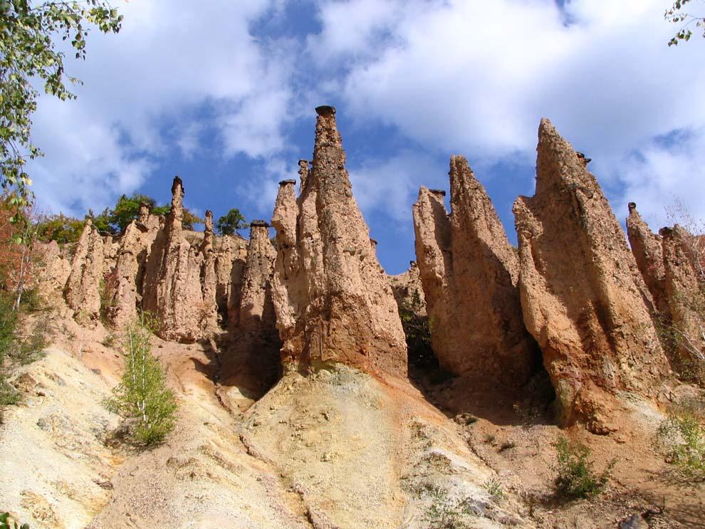 Devil's Town | |
| Highest point | |
| Elevation | 1,408 m (4,619 ft)[1] |
| Coordinates | 43°00′12″N 21°29′48″E |
| Geography | |
 Radan Serbia | |
| Location | Southern Serbia |
Radan separates the valleys of the Toplica and Jablanica rivers. It is well covered with deciduous and evergreen forests.[2]
The best known spot on Radan is the Devil's Town – a peculiar rock formation consisting of hundreds of mushroom-like posts, located on its southern slopes.[3] Near the Devil's Town there are ruins of Ivanova kula – city of Ivan Kosančić, medieval military commander.[4] Justiniana Prima (Caričin grad), a Byzantine city from the 6th century, is located on the southeast of the mountain, near Lebane.[2]
In summer 2010, Radan attracted media attention because of a "magnetic hill" located on a road near the village of Ivanje. After initial sensationalist articles about "anti-gravity", it soon turned out that it is just an optical illusion. Still, the hill is seen as an opportunity for a tourist attraction.[5]
Nature Park
In October 2017 the government placed part of the mountain under the protection, as the Nature Park Radan, citing its geological, biological and landscape diversity. It spreads over the area of four municipalities, Bojnik, Medveđa, Prokuplje and Kuršumlija, and covers an area of 41,312.66 ha (102,085.8 acres). Declared the "protected area of exceptional importance" (IUCN Category I), it is divided in three levels of protection, with the highest level occupying 1,077.52 ha (2,662.6 acres) or 2,61% of the total area. Though the best known feature on the mountain, the Devil's Town is not included in the newly formed nature park, though it was previously declared a geo-park on its own.[6]
References
- Jovan Đokić. "Katalog planina Srbije". PSD Kopaonik Beograd. Archived from the original on 2011-05-18.
- Radan (in Serbian), PD Pobeda, retrieved 2010-08-19
- About Devil's Town, Official Devil's Town website, retrieved 2010-08-19
- "Turistička organizacija Kuršumlija - Ivan kula". Archived from the original on 2013-10-29. Retrieved 2013-10-26.
- Tamo gde je nebo palo dole (in Serbian), Vreme, 2010-08-12, retrieved 2010-08-19
- Slavica Stuparušić (16 October 2017), "Još dva parka prirode na mapi Srbije" [Two more nature parks on the map of Serbia], Politika (in Serbian), p. 08
| Authority control: National libraries |
|---|
This Serbia location article is a stub. You can help Wikipedia by expanding it. |
На других языках
- [en] Radan (mountain)
[fr] Radan
Le mont Radan (en serbe cyrillique : Радан) est une montagne du sud-est de la Serbie. Il culmine à 1 408 m d'altitude au pic de Šopot.Другой контент может иметь иную лицензию. Перед использованием материалов сайта WikiSort.org внимательно изучите правила лицензирования конкретных элементов наполнения сайта.
WikiSort.org - проект по пересортировке и дополнению контента Википедии