geo.wikisort.org - Mountains
Džini Beg (Albanian: Gjini Beg and Tërpeznica; Macedonian: Џини Бег) is a peak in the Šar Mountains found on the boundary between Kosovo[a] and North Macedonia. Dzini Beg reaches a top height of 2,610 m (8,563 ft) and is totally covered with short grass.[citation needed] To the extreme south of Džini Beg in Kosovo is the large Dinivodno Lake which is shaped like a circle and is 80 cm (31 in) deep.[1][2]
| Džini Beg | |
|---|---|
 Gjini Beg and Terpeznica | |
| Highest point | |
| Elevation | 2,610 m (8,560 ft) |
| Coordinates | 42°02′39″N 20°45′59″E |
| Geography | |
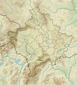 Džini Beg Kosovo[a] | |
| Parent range | Šar Mountains |
Notes and references
Notes:
| a. | ^ The political status of Kosovo is disputed. Having unilaterally declared independence from Serbia in 2008, Kosovo is formally recognised as an independent state by 97 UN member states (with another 15 states recognising it at some point but then withdrawing their recognition), while Serbia continues to claim it as part of its own sovereign territory. |
References:
- Tërpeznica - Gjini Beg (Sharr Mountains)
- "NGA GEOnet Names Server". National Geospatial-Intelligence Agency. 2009-09-09. Archived from the original on 2003-10-08. Retrieved 2010-01-01.
This Kosovo location article is a stub. You can help Wikipedia by expanding it. |
This North Macedonia location article is a stub. You can help Wikipedia by expanding it. |
Текст в блоке "Читать" взят с сайта "Википедия" и доступен по лицензии Creative Commons Attribution-ShareAlike; в отдельных случаях могут действовать дополнительные условия.
Другой контент может иметь иную лицензию. Перед использованием материалов сайта WikiSort.org внимательно изучите правила лицензирования конкретных элементов наполнения сайта.
Другой контент может иметь иную лицензию. Перед использованием материалов сайта WikiSort.org внимательно изучите правила лицензирования конкретных элементов наполнения сайта.
2019-2026
WikiSort.org - проект по пересортировке и дополнению контента Википедии
WikiSort.org - проект по пересортировке и дополнению контента Википедии