geo.wikisort.org - Island
The Taillefer Rocks, part of the Schouten Island Group, are three small, rugged, granite islands, with a combined area of approximately 15 hectares (37 acres) lying close to the eastern coast of Tasmania, Australia, near the Freycinet Peninsula and lies within the Freycinet National Park.[1][2]
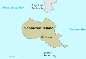 Map of Taillefer Rocks and Schouten Island | |
 Taillefer Rocks Location of Taillefer Rocks in Tasmania | |
| Geography | |
|---|---|
| Location | East coast of Tasmania |
| Coordinates | 42°21′36″S 148°18′36″E |
| Archipelago | Schouten Island Group |
| Adjacent bodies of water | Tasman Sea |
| Total islands | 3 |
| Area | 15 ha (37 acres) |
| Administration | |
Australia | |
| State | Tasmania |
| Local government area | Glamorgan Spring Bay Council |
| Additional information | |
| Time zone |
|
| • Summer (DST) |
|
| Freycinet National Park | |
Flora and fauna
This is one of the few islands where Oyster Bay pines occur.
Recorded breeding seabird species are little penguin, short-tailed shearwater, fairy prion and common diving petrel. Reptiles present include the metallic skink, White's skink, spotted skink and mountain dragon. Australian fur seals haul-out there in small numbers.[2]
See also
- Protected areas of Tasmania
- List of islands of Tasmania
References
- "Schouten" (Map). Tasmap. Tasmania: Mapping Division, Tasmanian Government. 1993. Retrieved 3 April 2015.
- Brothers, Nigel; Pemberton, David; Pryor, Helen; Halley, Vanessa (2001). Tasmania's Offshore Islands: seabirds and other natural features. Hobart: Tasmanian Museum and Art Gallery. ISBN 978-0-7246-4816-0.
East Coast region of Tasmania, Australia | |||||
|---|---|---|---|---|---|
| Settlements |
| ||||
| Governance former |
| ||||
| Mountains | |||||
| Protected areas, parks and reserves |
| ||||
| Harbours, bays, inlets and estuaries | |||||
| Landmarks |
| ||||
| People of note |
| ||||
| Islands |
| ||||
| Books and newspapers |
| ||||
| Flora, fauna, and fishlife |
| ||||
| Bioregions |
| ||||
| |||||
This Tasmania geography article is a stub. You can help Wikipedia by expanding it. |
На других языках
- [en] Taillefer Rocks
[fr] Île Taillefer
L'île Taillefer est une île australienne située dans l'océan Pacifique au large de la côte est de la Tasmanie et au sud de l'île Schouten. Elle a été nommée durant l'expédition Baudin en l'honneur d'Hubert Jules Taillefer, médecin qui participa à ce voyage d'exploration scientifique français parti du Havre le 19 octobre 1800.Текст в блоке "Читать" взят с сайта "Википедия" и доступен по лицензии Creative Commons Attribution-ShareAlike; в отдельных случаях могут действовать дополнительные условия.
Другой контент может иметь иную лицензию. Перед использованием материалов сайта WikiSort.org внимательно изучите правила лицензирования конкретных элементов наполнения сайта.
Другой контент может иметь иную лицензию. Перед использованием материалов сайта WikiSort.org внимательно изучите правила лицензирования конкретных элементов наполнения сайта.
2019-2026
WikiSort.org - проект по пересортировке и дополнению контента Википедии
WikiSort.org - проект по пересортировке и дополнению контента Википедии