geo.wikisort.org - Reservoir
The lakes of Titan, Saturn's largest moon, are bodies of liquid ethane and methane that have been detected by the Cassini–Huygens space probe, and had been suspected long before.[2] The large ones are known as maria (seas) and the small ones as lacūs (lakes).[3]
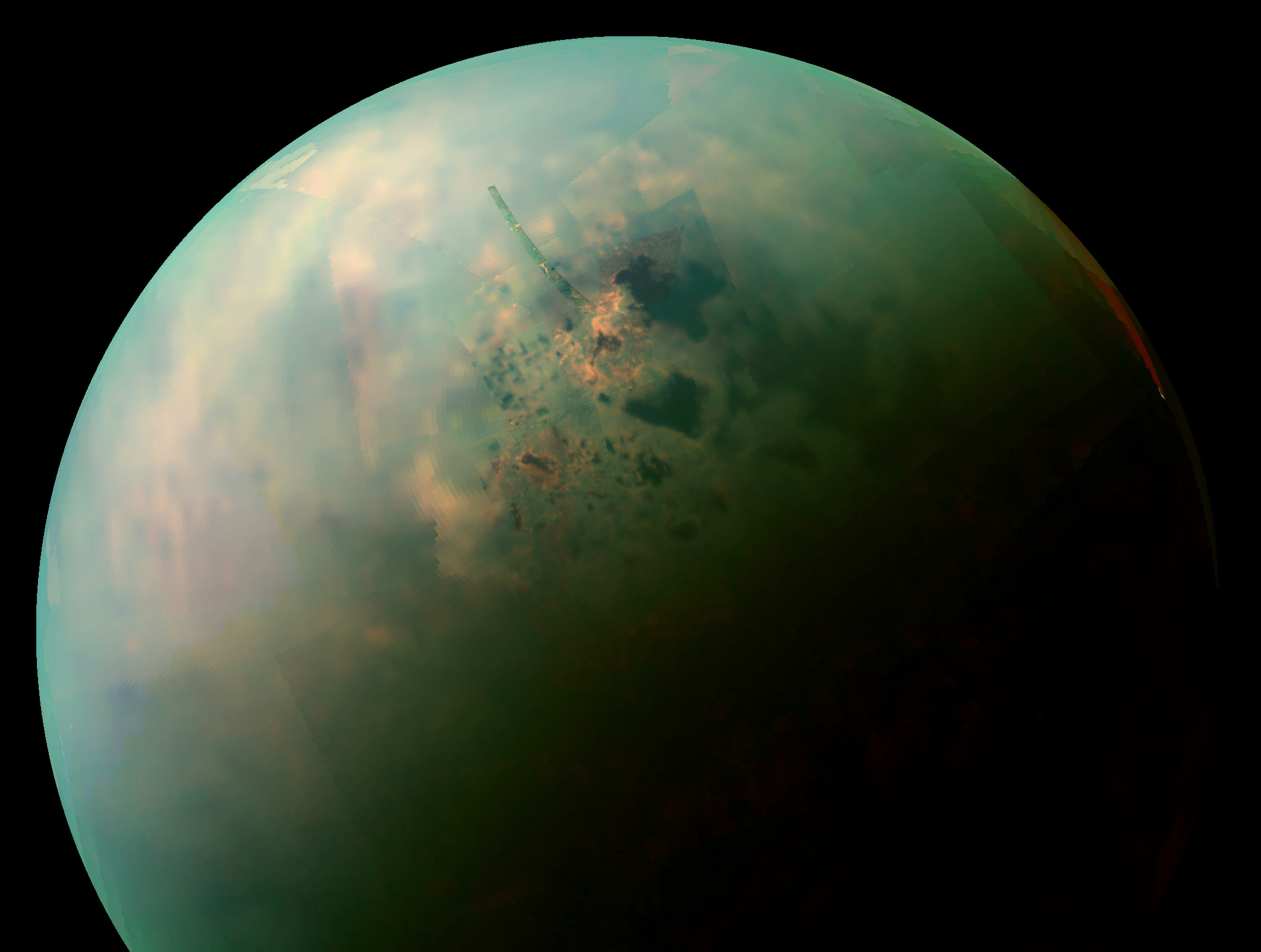
![False-color, medium-resolution Cassini synthetic aperture radar mosaic of Titan's north polar region, showing hydrocarbon seas, lakes and tributary networks. Blue coloring indicates low radar reflectivity areas, caused by bodies of liquid ethane, methane and dissolved nitrogen.[1] Kraken Mare, the largest sea on Titan, is at lower left. Ligeia Mare is the large body below the pole, and Punga Mare at half its size is just left of the pole. White areas have not been imaged.](http://upload.wikimedia.org/wikipedia/commons/9/93/PIA17655_crop_Titan_north_polar_seas_and_lakes.jpg)
History


![Vid Flumina,[4] a 400-kilometer-long (250 mi) river emptying into Ligeia Mare (in lower right corner of top image).](http://upload.wikimedia.org/wikipedia/commons/f/fa/PIA16197_Titan_river.jpg)
The possibility that there were seas on Titan was first suggested based on data from the Voyager 1 and 2 space probes, launched in August and September 1977. The data showed Titan to have a thick atmosphere of approximately the correct temperature and composition to support them. Direct evidence was not obtained until 1995 when data from the Hubble Space Telescope and other observations had already suggested the existence of liquid methane on Titan, either in disconnected pockets or on the scale of satellite-wide oceans, similar to water on Earth.[5]
The Cassini mission affirmed the former hypothesis, although not immediately. When the probe arrived in the Saturnian system in 2004, it was hoped that hydrocarbon lakes or oceans might be detectable by reflected sunlight from the surface of any liquid bodies, but no specular reflections were initially observed.[6]
The possibility remained that liquid ethane and methane might be found on Titan's polar regions, where they were expected to be abundant and stable.[7] In Titan's south polar region, an enigmatic dark feature named Ontario Lacus was the first suspected lake identified, possibly created by clouds that are observed to cluster in the area.[8] A possible shoreline was also identified near the pole via radar imagery.[9] Following a flyby on July 22, 2006, in which the Cassini spacecraft's radar imaged the northern latitudes, which were at the time in winter. A number of large, smooth (and thus dark to radar) patches were seen dotting the surface near the pole.[10] Based on the observations, scientists announced "definitive evidence of lakes filled with methane on Saturn's moon Titan" in January 2007.[7][11] The Cassini–Huygens team concluded that the imaged features are almost certainly the long-sought hydrocarbon lakes, the first stable bodies of surface liquid found off Earth. Some appear to have channels associated with liquid and lie in topographical depressions.[7] Channels in some regions have created surprisingly little erosion, suggesting erosion on Titan is extremely slow, or some other recent phenomena may have wiped out older riverbeds and landforms.[12] Overall, the Cassini radar observations have shown that lakes cover only a few percent of the surface and are concentrated near the poles, making Titan much dryer than Earth.[13] The high relative humidity of methane in Titan's lower atmosphere could be maintained by evaporation from lakes covering only 0.002–0.02% of the whole surface.[14]
During a Cassini flyby in late February 2007, radar and camera observations revealed several large features in the north polar region interpreted as large expanses of liquid methane and/or ethane, including one, Ligeia Mare, with an area of 126,000 km2 (49,000 sq mi), slightly larger than Lake Michigan–Huron, the largest freshwater lake on Earth; and another, Kraken Mare, that would later prove to be three times that size. A flyby of Titan's southern polar regions in October 2007 revealed similar, though far smaller, lakelike features.[15]


During a close Cassini flyby in December 2007 the visual and mapping instrument observed a lake, Ontario Lacus, in Titan's south polar region. This instrument identifies chemically different materials based on the way they absorb and reflect infrared light. Radar measurements made in July 2009 and January 2010 indicate that Ontario Lacus is extremely shallow, with an average depth of 0.4–3.2 m (1 ft 4 in – 10 ft 6 in), and a maximum depth of 2.9–7.4 m (9 ft 6 in – 24 ft 3 in).[16] It may thus resemble a terrestrial mudflat. In contrast, the northern hemisphere's Ligeia Mare has depths of 170 m (560 ft).[17]
Chemical composition and surface roughness of the lakes
According to Cassini data, scientists announced on February 13, 2008, that Titan hosts within its polar lakes "hundreds of times more natural gas and other liquid hydrocarbons than all the known oil and natural gas reserves on Earth." The desert sand dunes along the equator, while devoid of open liquid, nonetheless hold more organics than all of Earth's coal reserves.[18] It has been estimated that the visible lakes and seas of Titan contain about 300 times the volume of Earth's proven oil reserves.[19] In June 2008, Cassini's Visible and Infrared Mapping Spectrometer confirmed the presence of liquid ethane beyond doubt in a lake in Titan's southern hemisphere.[20] The exact blend of hydrocarbons in the lakes is unknown. According to a computer model, 3/4 of an average polar lake is ethane, with 10 percent methane, 7 percent propane and smaller amounts of hydrogen cyanide, butane, nitrogen and argon.[21] Benzene is expected to fall like snow and quickly dissolve into the lakes, although the lakes may become saturated just as the Dead Sea on Earth is packed with salt. The excess benzene would then build up in a mud-like sludge on the shores and on the lake floors before eventually being eroded by ethane rain, forming a complex cave-riddled landscape.[22] Salt-like compounds composed of ammonia and acetylene are also predicted to form.[23] However, the chemical composition and physical properties of the lakes probably varies from one lake to another (Cassini observations in 2013 indicate Ligeia Mare is filled with a ternary mixture of methane, ethane, and nitrogen and consequently the probe's radar signals were able to detect the sea floor 170 m [560 ft] below the liquid surface).[24]
No waves were initially detected by Cassini as the northern lakes emerged from winter darkness (calculations indicate wind speeds of less than 1 meter per second [2.2 mph] should whip up detectable waves in Titan's ethane lakes but none were observed). This may be either due to low seasonal winds or solidification of hydrocarbons. Titan has several lakes that reside near its norther pole that vary in size, the area these lakes cover and lower wind speeds could as well explain why there were no surface waves being detected. The area over a liquid that wind blows across is known as fetch[25]. The larger this area is, the larger waves become as wind has more area to blow across to transfer energy. The smaller the area of fetch, the smaller waves will be. The optical properties of solid methane surface (close to the melting point) are quite close to the properties of liquid surface however the viscosity of solid methane, even near the melting point, is many orders of magnitude higher, which might explain extraordinary smoothness of the surface.[26] Solid methane is denser than liquid methane so it will eventually sink. It is possible that the methane ice could float for a time as it probably contains bubbles of nitrogen gas from Titan's atmosphere.[27] Temperatures close to the freezing point of methane (90.4 K, −182.8 °C, −296.9 °F) could lead to both floating and sinking ice - that is, a hydrocarbon ice crust above the liquid and blocks of hydrocarbon ice on the bottom of the lake bed. The ice is predicted to rise to the surface again at the onset of spring before melting.
Since 2014, Cassini has detected transient features in scattered patches in Kraken Mare, Ligeia Mare and Punga Mare. Laboratory experiments suggest these features (e.g. RADAR-bright "magic islands")[28] might be vast patches of bubbles caused by the rapid release of nitrogen dissolved in the lakes. Bubble outburst events are predicted to occur as the lakes cool and subsequently warm or whenever methane-rich fluids mix with ethane-rich ones due to heavy rainfall.[29][30] Bubble outburst events may also influence the formation of Titan's river deltas.[30] An alternative explanation is the transient features in Cassini VIMS near-infrared data may be shallow, wind-driven capillary waves (ripples) moving at about 0.7 m/s (1.6 mph) and at heights of about 1.5 centimeters (0.59 in).[31][32][33] Post-Cassini analysis of VIMS data suggests tidal currents may also be responsible for the generation of persistent waves in narrow channels (Freta) of Kraken Mare.[33]
Cyclones driven by evaporation and involving rain as well as gale-force winds of up to 20 m/s (72 km/h; 45 mph) are expected to form over the large northern seas only (Kraken Mare, Ligeia Mare, Punga Mare) in northern summer during 2017, lasting up to ten days.[34] However, a 2017 analysis of Cassini data from 2007 to 2015 indicates waves across these three seas were diminutive, reaching only about 1 centimeter (0.39 in) high and 20 centimeters (7.9 in) long. The results call into question the early summer's classification as the beginning of the Titan's windy season, because high winds probably would have made for larger waves.[35] A 2019 theoretical study concluded that it is possible that the relatively dense aerosols raining down on Titan's lakes may have liquid-repelling properties, forming a persistent film on the surface of the lakes which then would inhibit formation of waves larger than a few centimetres in wavelength.[36]
Observation of specular reflections

On 21 December 2008, Cassini passed directly over Ontario Lacus at an altitude of 1,900 km (1,200 mi) and was able to observe specular reflection in radar observations. The signals were much stronger than anticipated and saturated the probe's receiver. The conclusion drawn from the strength of the reflection was that the lake level did not vary by more than 3 mm (0.12 in) over a first Fresnel zone reflecting area only 100 m (330 ft) wide (smoother than any natural dry surface on Earth). From this it was surmised that surface winds in the area are minimal at that season and/or the lake fluid is more viscous than expected.[37][38]
On 8 July 2009, Cassini's Visual and Infrared Mapping Spectrometer (VIMS) observed a specular reflection in 5 µm infrared light off a northern hemisphere body of liquid at 71° N, 337° W. This has been described as at the southern shoreline of Kraken Mare,[39] but on a combined radar-VIMS image the location is shown as a separate lake (later named Jingpo Lacus). The observation was made shortly after the north polar region emerged from 15 years of winter darkness. Because of the polar location of the reflecting liquid body, the observation required a phase angle close to 180°.[40]
Equatorial in-situ observations by the Huygens probe
The discoveries in the polar regions contrast with the findings of the Huygens probe, which landed near Titan's equator on January 14, 2005. The images taken by the probe during its descent showed no open areas of liquid, but strongly indicated the presence of liquids in the recent past, showing pale hills crisscrossed with dark drainage channels that lead into a wide, flat, darker region. It was initially thought that the dark region might be a lake of a fluid or at least tar-like substance, but it is now clear that Huygens landed on the dark region, and that it is solid without any indication of liquids. A penetrometer studied the composition of the surface as the craft impacted it, and it was initially reported that the surface was similar to wet clay, or perhaps crème brûlée (that is, a hard crust covering a sticky material). Subsequent analysis of the data suggests that this reading was likely caused by Huygens displacing a large pebble as it landed, and that the surface is better described as a "sand" made of ice grains.[41] The images taken after the probe's landing show a flat plain covered in pebbles. The pebbles may be made of water ice and are somewhat rounded, which may indicate the action of fluids.[42] Thermometers indicated that heat was wicked away from Huygens so quickly that the ground must have been damp, and one image shows light reflected by a dewdrop as it falls across the camera's field of view. On Titan, the feeble sunlight allows only about one centimeter of evaporation per year (versus one meter of water on Earth), but the atmosphere can hold the equivalent of about 10 meters (33 ft) of liquid before rain forms (versus about 2 cm [0.79 in] on Earth). So Titan's weather is expected to feature downpours of several meters (15–20 feet) causing flash floods, interspersed by decades or centuries of drought (whereas typical weather on Earth includes a little rain most weeks).[43] Cassini has observed equatorial rainstorms only once since 2004. Despite this, a number of long-standing tropical hydrocarbon lakes were unexpectedly discovered in 2012[44] (including one near the Huygens landing site in the Shangri-La region which is about half the size of Utah's Great Salt Lake, with a depth of at least 1 meter [3'4"]). As on Earth, the likely supplier is probably underground aquifers, in other words the arid equatorial regions of Titan contain "oases".[45]
Impact of Titan's methane cycle and geology on lake formation

(artist concept)


Models of oscillations in Titan's atmospheric circulation suggest that over the course of a Saturnian year, liquid is transported from the equatorial region to the poles, where it falls as rain. This might account for the equatorial region's relative dryness.[46] According to a computer model, intense rainstorms should occur in normally rainless equatorial areas during Titan's vernal and autumnal equinoxes—enough liquid to carve out the type of channels that Huygens found.[47] The model also predicts energy from the Sun will evaporate liquid methane from Titan's surface except at the poles, where the relative absence of sunlight makes it easier for liquid methane to accumulate into permanent lakes. The model also apparently explains why there are more lakes in the northern hemisphere. Due to the eccentricity of Saturn's orbit, the northern summer is longer than the southern summer and consequently the rainy season is longer in the north.
However, recent Cassini observations (from 2013) suggest geology may also explain the geographic distribution of the lakes and other surface features. One puzzling feature of Titan is the lack of impact craters at the poles and mid-latitudes, particularly at lower elevations. These areas may be wetlands fed by subsurface ethane and methane springs.[48] Any crater created by meteorites is thus quickly subsumed by wet sediment. The presence of underground aquifers could explain another mystery. Titan's atmosphere is full of methane, which according to calculations should react with ultraviolet radiation from the sun to produce liquid ethane. Over time, the moon should have built up an ethane ocean hundreds of meters (1,500 to 2,500 feet) deep instead of only a handful of polar lakes. The presence of wetlands would suggest that the ethane soaks into the ground, forming a subsurface liquid layer akin to groundwater on Earth. A possibility is that the formation of materials called clathrates changes the chemical composition of the rainfall runoff that charges the subsurface hydrocarbon "aquifers." This process leads to the formation of reservoirs of propane and ethane that may feed into some rivers and lakes. The chemical transformations taking place underground would affect Titan's surface. Lakes and rivers fed by springs from propane or ethane subsurface reservoirs would show the same kind of composition, whereas those fed by rainfall would be different and contain a significant fraction of methane.[49]
All but 3% of Titan's lakes have been found within a bright unit of terrain covering about 900 by 1,800 kilometers (560 by 1,120 mi) near the north pole. The lakes found here have very distinctive shapes—rounded complex silhouettes and steep sides—suggesting deformation of the crust created fissures that could be filled up with liquid. A variety of formation mechanisms have been proposed. The explanations range from the collapse of land after a cryovolcanic eruption to karst terrain, where liquids dissolve soluble ice.[50] Smaller lakes (up to tens of miles across) with steep rims (up to hundreds of feet high) might be analogous to maar lakes, i.e. explosion craters subsequently filled with liquid. The explosions are proposed to result from fluctuations in climate, which lead to pockets of liquid nitrogen accumulating within the crust during colder periods and then exploding when warming caused the nitrogen to rapidly expand as it shifted to a gas state.[51][52][53]
Titan Mare Explorer
Titan Mare Explorer (TiME) was a proposed NASA/ESA lander that would splash down on Ligeia Mare and analyze its surface, shoreline and Titan's atmosphere.[54] However, it was turned down in August 2012, when NASA instead selected the InSight mission to Mars.[55]
Named lakes and seas


Features labeled lacus are believed to be ethane/methane lakes, while features labeled lacuna are believed to be dry lake beds. Both are named after lakes on Earth.[3] Features labeled sinus are bays within the lakes or seas. They are named after bays and fjords on Earth. Features labeled insula are islands within the body of liquid. They are named after mythical islands. Titanean maria (large hydrocarbon seas) are named after sea monsters in world mythology.[3] The tables are up-to-date as of 2020.[56]
Sea names of Titan
| Name | Coordinates | Length (km)[note 1] | Area (km2) | Source of name |
|---|---|---|---|---|
| Kraken Mare | 68.0°N 310.0°W | 1,170 | 400,000 | The Kraken, Norse sea monster. |
| Ligeia Mare | 79.0°N 248.0°W | 500 | 126,000 | Ligeia, one of the Sirens, Greek monsters |
| Punga Mare | 85.1°N 339.7°W | 380 | 40,000 | Punga, Māori ancestor of sharks and lizards |
Lake names of Titan
| Name | Coordinates | Length (km)[note 1] | Source of name |
|---|---|---|---|
| Abaya Lacus | 73.17°N 45.55°W | 65 | Lake Abaya, Ethiopia |
| Akmena Lacus | 85.1°N 55.6°W | 35.6 | Lake Akmena, Lithuania |
| Albano Lacus | 65.9°N 236.4°W | 6.2 | Lake Albano, Italy |
| Annecy Lacus | 76.8°N 128.9°W | 20 | Lake Annecy, France |
| Arala Lacus | 78.1°N 124.9°W | 12.3 | Lake Arala, Mali |
| Atitlán Lacus | 69.3°N 238.8°W | 13.7 | Lake Atitlán, Guatemala |
| Balaton Lacus | 82.9°N 87.5°W | 35.6 | Lake Balaton, Hungary |
| Bolsena Lacus | 75.75°N 10.28°W | 101 | Lake Bolsena, Italy |
| Brienz Lacus | 85.3°N 43.8°W | 50.6 | Lake Brienz, Switzerland |
| Buada Lacus | 76.4°N 129.6°W | 76.4 | Buada Lagoon, Nauru |
| Cardiel Lacus | 70.2°N 206.5°W | 22 | Cardiel Lake, Argentina |
| Cayuga Lacus | 69.8°N 230.0°W | 22.7 | Cayuga Lake, USA |
| Chilwa Lacus | 75°N 131.3°W | 19.8 | Lake Chilwa, near Malawi-Mozambique border |
| Crveno Lacus | 79.6°S 184.9°W | 41.0 | Crveno Jezero, Croatia |
| Dilolo Lacus | 76.2°N 125°W | 18.3 | Dilolo Lake, Angola |
| Dridzis Lacus | 78.9°N 131.3°W | 50 | Lake Dridzis, Latvia |
| Feia Lacus | 73.7°N 64.41°W | 47 | Lake Feia, Brazil |
| Fogo Lacus | 81.9°N 98°W | 32.3 | Lagoa do Fogo, Azores, Portugal |
| Freeman Lacus | 73.6°N 211.1°W | 26 | Lake Freeman, USA |
| Grasmere Lacus | 72.3°N 103.1°W | 33.3 | Grasmere Lake, England |
| Hammar Lacus | 48.6°N 308.29°W | 200 | Lake Hammar, Iraq |
| Hlawga Lacus | 76.6°N 103.6°W | 40.3 | Lake Hlawga, Myanmar |
| Ihotry Lacus | 76.1°N 137.2°W | 37.5 | Lake Ihotry, Madagascar |
| Imogene Lacus | 71.1°N 111.8°W | 38 | Imogene Lake, USA |
| Jingpo Lacus | 73.0°N 336.0°W | 240 | Jingpo Lake, China |
| Junín Lacus | 66.9°N 236.9°W | 6.3 | Lake Junín, Peru |
| Karakul Lacus | 86.3°N 56.6°W | 18.4 | Lake Karakul, Tajikistan |
| Kayangan Lacus | 86.3°S 236.9°W | 6.2 | Kayangan Lake, Philippines |
| Kivu Lacus | 87.0°N 121.0°W | 77.5 | Lake Kivu, on the border of Rwanda and the Democratic Republic of the Congo |
| Koitere Lacus | 79.4°N 36.14°W | 68 | Koitere, Finland |
| Ladoga Lacus | 74.8°N 26.1°W | 110 | Lake Ladoga, Russia |
| Lagdo Lacus | 75.5°N 125.7°W | 37.8 | Lagdo Reservoir, Cameroon |
| Lanao Lacus | 71.0°N 217.7°W | 34.5 | Lake Lanao, Philippines |
| Letas Lacus | 81.3°N 88.2°W | 23.7 | Lake Letas, Vanuatu |
| Logtak Lacus | 70.8°N 124.1°W | 14.3 | Loktak Lake, India |
| Mackay Lacus | 78.32°N 97.53°W | 180 | Lake Mackay, Australia |
| Maracaibo Lacus | 75.3°N 127.7°W | 20.4 | Lake Maracaibo, Venezuela |
| Müggel Lacus | 84.44°N 203.5°W | 170 | Müggelsee, Germany |
| Muzhwi Lacus | 74.8°N 126.3°W | 36 | Muzhwi Dam, Zimbabwe |
| Mweru Lacus | 71.9°N 131.8°W | 20.6 | Lake Mweru, on Zambia-Democratic Republic of the Congo border |
| Mývatn Lacus | 78.19°N 135.28°W | 55 | Mývatn, Iceland |
| Neagh Lacus | 81.11°N 32.16°W | 98 | Lough Neagh, Northern Ireland |
| Negra Lacus | 75.5°N 128.9°W | 15.3 | Lake Negra, Uruguay |
| Ohrid Lacus | 71.8°N 221.9°W | 17.3 | Lake Ohrid, on the border of North Macedonia and Albania |
| Olomega Lacus | 78.7°N 122.2°W | 15.7 | Lake Olomega, El Salvador |
| Oneida Lacus | 76.14°N 131.83°W | 51 | Oneida Lake, United States |
| Ontario Lacus | 72.0°S 183.0°W | 235 | Lake Ontario, on the border between Canada and the United States. |
| Phewa Lacus | 72.2°N 124°W | 12 | Phewa Lake, Nepal |
| Prespa Lacus | 73.1°N 135.7°W | 43.7 | Lake Prespa, on tripoint of North Macedonia, Albania and Greece |
| Qinghai Lacus | 83.4°N 51.5°W | 44.3 | Qinghai Lake, China |
| Quilotoa Lacus | 80.3°N 120.1°W | 11.8 | Quilotoa, Ecuador |
| Rannoch Lacus | 74.2°N 129.3°W | 63.5 | Loch Rannoch, Scotland |
| Roca Lacus | 79.8°N 123.5°W | 46 | Las Rocas Lake, Chile |
| Rukwa Lacus | 74.8°N 134.8°W | 36 | Lake Rukwa, Tanzania |
| Rwegura Lacus | 71.5°N 105.2°W | 21.7 | Rwegura Dam, Burundi |
| Sevan Lacus | 69.7°N 225.6°W | 46.9 | Lake Sevan, Armenia |
| Shoji Lacus | 79.7°S 166.4°W | 5.8 | Lake Shoji, Japan |
| Sionascaig Lacus | 41.52°S 278.12°W | 143.2 | Loch Sionascaig, Scotland |
| Sotonera Lacus | 76.75°N 17.49°W | 63 | Lake Sotonera, Spain |
| Sparrow Lacus | 84.3°N 64.7°W | 81.4 | Sparrow Lake, Canada |
| Suwa Lacus | 74.1°N 135.2°W | 12 | Lake Suwa, Japan |
| Synevyr Lacus | 81°N 53.6°W | 36 | Lake Synevyr, Ukraine |
| Taupo Lacus | 72.7°N 132.6°W | 27 | Lake Taupo, New Zealand |
| Tengiz Lacus | 73.2°N 105.6°W | 70 | Lake Tengiz, Kazakhstan |
| Toba Lacus | 70.9°N 108.1°W | 23.6 | Lake Toba, Indonesia |
| Towada Lacus | 71.4°N 244.2°W | 24 | Lake Towada, Japan |
| Trichonida Lacus | 81.3°N 65.3°W | 31.5 | Lake Trichonida, Greece |
| Tsomgo Lacus | 86.4°S 162.4°W | 59 | Lake Tsomgo, India |
| Urmia Lacus | 39.27°S 276.55°W | 28.6 | Lake Urmia, Iran |
| Uvs Lacus | 69.6°N 245.7°W | 26.9 | Uvs Lake, Mongolia |
| Vänern Lacus | 70.4°N 223.1°W | 43.9 | Vänern, Sweden |
| Van Lacus | 74.2°N 137.3°W | 32.7 | Lake Van, Turkey |
| Viedma Lacus | 72°N 125.7°W | 42 | Viedma Lake, Argentina |
| Waikare Lacus | 81.6°N 126.0°W | 52.5 | Lake Waikare, New Zealand |
| Weija Lacus | 68.77°N 327.68°W | 12 | Lake Weija, Ghana |
| Winnipeg Lacus | 78.05°N 153.31°W | 60 | Lake Winnipeg, Canada |
| Xolotlán Lacus | 82.3°N 72.9°W | 57.4 | Lake Xolotlán, Nicaragua |
| Yessey Lacus | 73°N 110.8°W | 24.5 | Lake Yessey, Siberia, Russia |
| Yojoa Lacus | 78.1°N 54.1°W | 58.3 | Lake Yojoa, Honduras |
| Ypoa Lacus | 73.4°N 132.2°W | 39.2 | Lake Ypoá, Paraguay |
| Zaza Lacus | 72.4°N 106.9°W | 29 | Zaza Reservoir, Cuba |
| Zub Lacus | 71.7°N 102.6°W | 19.5 | Zub Lake, Antarctica |
Lakebed names of Titan
| Lacunae | Coordinates | Length (km)[note 1] | Named after |
|---|---|---|---|
| Atacama Lacuna | 68.2°N 227.6°W | 35.9 | Salar de Atacama, intermittent lake in Chile |
| Eyre Lacuna | 72.6°N 225.1°W | 25.4 | Lake Eyre, intermittent lake in Australia[57] |
| Jerid Lacuna | 66.7°N 221°W | 42.6 | Chott el Djerid, intermittent lake in Tunisia |
| Kutch Lacuna | 88.4°N 217°W | 175 | Great Rann of Kutch, intermittent lake on Pakistani-Indian border |
| Melrhir Lacuna | 64.9°N 212.6°W | 23 | Chott Melrhir, intermittent lake in Algeria |
| Nakuru Lacuna | 65.81°N 94°W | 188 | Lake Nakuru, intermittent lake in Kenya |
| Ngami Lacuna | 66.7°N 213.9°W | 37.2 | Lake Ngami, in Botswana,[58] and like its terrestrial namesake is considered to be endorheic |
| Racetrack Lacuna | 66.1°N 224.9°W | 9.9 | Racetrack Playa, intermittent lake in California, USA |
| Uyuni Lacuna | 66.3°N 228.4°W | 27 | Salar de Uyuni, intermittent lake and world's largest salt flat in Bolivia |
| Veliko Lacuna | 76.8°S 33.1°W | 93 | Veliko Lake, intermittent lake in Bosnia-Herzegovina |
| Woytchugga Lacuna | 68.88°N 109.0°W | 449 | Indications are that it is an intermittent lake and so was named in 2013 after Lake Woytchugga near Wilcannia, Australia.[59][60] |
Bay names of Titan
| Name | Coordinates | Liquid body | Length (km)[note 1] | Source of name |
|---|---|---|---|---|
| Arnar Sinus | 72.6°N 322°W | Kraken Mare | 101 | Arnar, fjord in Iceland |
| Avacha Sinus | 82.87°N 335.43°W | Punga Mare | 51 | Avacha Bay in Kamchatka, Russia |
| Baffin Sinus | 80.35°N 344.62°W | Kraken Mare | 110 | Baffin Bay between Canada and Greenland |
| Boni SInus | 78.69°N 345.38°W | Kraken Mare | 54 | Gulf of Boni in Indonesia |
| Dingle Sinus | 81.36°N 336.44°W | Kraken Mare | 80 | Dingle Bay in Ireland |
| Fagaloa Sinus | 82.9°N 320.5°W | Punga Mare | 33 | Fagaloa Bay in Upolu Island, Samoa |
| Flensborg Sinus | 64.9°N 295.3°W | Kraken Mare | 115 | Flensburg Firth, fjord between Denmark and Germany |
| Fundy Sinus | 83.26°N 315.64°W | Punga Mare | 91 | Bay of Fundy in Canada that hosts the world's largest tides[61] |
| Gabes Sinus | 67.6°N 289.6°W | Kraken Mare | 147 | Gabes, or Syrtis minor, a bay in Tunisia |
| Genova Sinus | 80.11°N 326.61°W | Kraken Mare | 125 | Gulf of Genoa in Italy |
| Kumbaru Sinus | 56.8°N 303.8°W | Kraken Mare | 122 | Bay in India |
| Lulworth Sinus | 67.19°N 316.88°W | Kraken Mare | 24 | Lulworth Cove in southern England |
| Maizuru Sinus | 78.9°N 352.53°W | Kraken Mare | 92 | Maizuru Bay in Japan |
| Manza Sinus | 79.29°N 346.1°W | Kraken Mare | 37 | Manza Bay in Tanzania |
| Moray Sinus | 76.6°N 281.4°W | Kraken Mare | 204 | Moray Firth in Scotland |
| Nicoya Sinus | 74.8°N 251.2°W | Ligeia Mare | 130 | Gulf of Nicoya in Costa Rica |
| Okahu Sinus | 73.7°N 282°W | Kraken Mare | 141 | Okahu Bay near Auckland, New Zealand |
| Patos Sinus | 77.2°N 224.8°W | Ligeia Mare | 103 | Patos, fjord in Chile |
| Puget Sinus | 82.4°N 241.1°W | Ligeia Mare | 93 | Puget Sound in Washington, United States |
| Rombaken Sinus | 75.3°N 232.9°W | Ligeia Mare | 92.5 | Rombaken, fjord in Norway |
| Saldanha Sinus | 82.42°N 322.5°W | Punga Mare | 18 | Saldanha Bay in South Africa |
| Skelton Sinus | 76.8°N 314.9°W | Kraken Mare | 73 | Skelton Glacier near Ross Sea, Antarctica |
| Trold Sinus | 71.3°N 292.7°W | Kraken Mare | 118 | Trold Fiord Formation in Nunavut, Canada |
| Tumaco Sinus | 82.55°N 315.22°W | Punga Mare | 31 | Tumaco, port city and bay in Colombia |
| Tunu Sinus | 79.2°N 299.8°W | Kraken Mare | 134 | Tunu, fjord in Greenland |
| Wakasa Sinus | 80.7°N 270°W | Ligeia Mare | 146 | Wakasa Bay in Japan |
| Walvis Sinus | 58.2°N 324.1°W | Kraken Mare | 253 | Walvis Bay in Namibia |
Island names of Titan
| Insula | Coordinates | Liquid body | Named after |
|---|---|---|---|
| Bermoothes Insula | 67.1°N 317.1°W | Kraken Mare | Bermoothes, an enchanted island in Shakespeare's Tempest |
| Bimini Insula | 73.3°N 305.4°W | Kraken Mare | Bimini, island in Arawak legend said to contain the fountain of youth. |
| Bralgu Insula | 76.2°N 251.5°W | Ligeia Mare | Baralku, in Yolngu culture, the island of the dead and the place where the Djanggawul, the three creator siblings, originated. |
| Buyan Insula | 77.3°N 245.1°W | Ligeia Mare | Buyan, a rocky island in Russian folk tales located on the south shore of Baltic Sea |
| Hawaiki Insulae | 84.32°N 327.07°W | Punga Mare | Hawaiki, original home island of the Polynesian people in local mythology |
| Hufaidh Insulae | 67°N 320.3°W | Kraken Mare | Hufaidh, legendary island in the marshes of southern Iraq |
| Krocylea Insulae | 69.1°N 302.4°W | Kraken Mare | Crocylea, mythological Greek island in the Ionian Sea, near Ithaca |
| Mayda Insula | 79.1°N 312.2°W | Kraken Mare | Mayda, legendary island in the northeast Atlantic |
| Onogoro Insula | 83.28°N 311.7°W | Punga Mare | Onogoro Island, Japanese mythological island |
| Penglai Insula | 72.2°N 308.7°W | Kraken Mare | Penglai, mythological Chinese mountain island where immortals and gods lived. |
| Planctae Insulae | 77.5°N 251.3°W | Ligeia Mare | Symplegades, the "clashing rocks" in Bosphorus, which only Argo was said to have successfully passed the rocks. |
| Royllo Insula | 38.3°N 297.2°W | Kraken Mare | Royllo, legendary island in the Atlantic, on verge of unknown, near Antilla and Saint Brandan. |
Image gallery
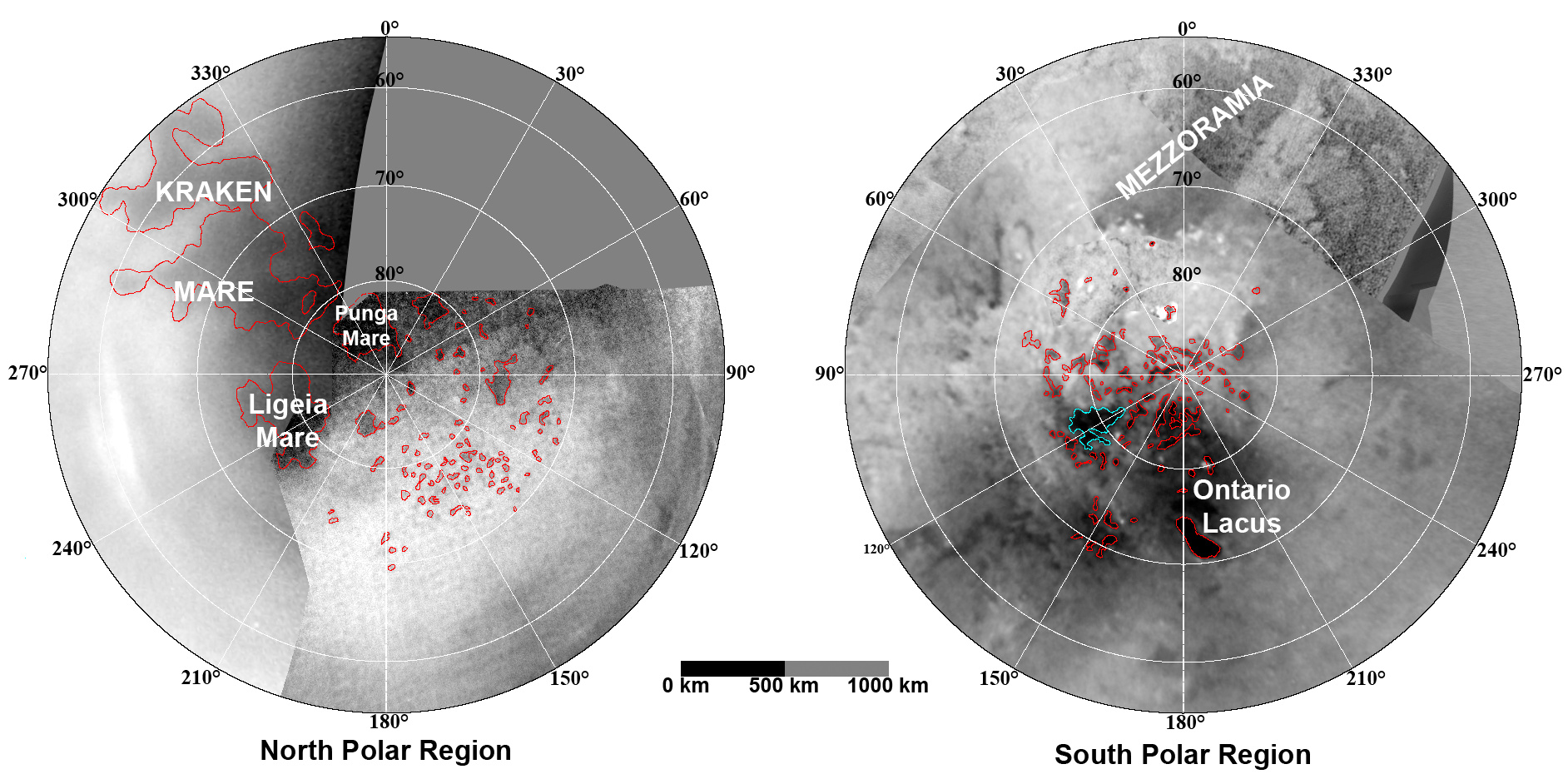
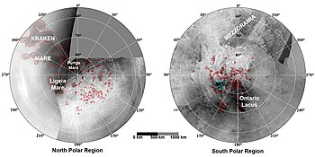 Maps of Titan's polar regions based on images from Cassini's ISS showing hydrocarbon lakes and seas. Bodies of liquid hydrocarbons are outlined in red; the blue outline indicates a body that appeared during the 2004-2005 interval.
![High-resolution false-color Cassini synthetic aperture radar mosaic of Titan's north polar region, showing hydrocarbon seas, lakes and tributary networks. Blue coloring indicates low radar reflectivity areas, caused by bodies of liquid ethane, methane and dissolved nitrogen.[1] About half of Kraken Mare, the large body at lower left, is outside the image. Ligeia Mare is the large body at lower right. Punga Mare is just left of center. Jingpo Lacus is just above Kraken Mare, and Bolsena Lacus is directly above it.](//upload.wikimedia.org/wikipedia/commons/thumb/d/d7/PIA10008_Seas_and_Lakes_on_Titan_full_size.jpg/210px-PIA10008_Seas_and_Lakes_on_Titan_full_size.jpg) High-resolution false-color Cassini synthetic aperture radar mosaic of Titan's north polar region, showing hydrocarbon seas, lakes and tributary networks. Blue coloring indicates low radar reflectivity areas, caused by bodies of liquid ethane, methane and dissolved nitrogen.[1] About half of Kraken Mare, the large body at lower left, is outside the image. Ligeia Mare is the large body at lower right. Punga Mare is just left of center. Jingpo Lacus is just above Kraken Mare, and Bolsena Lacus is directly above it.
High-resolution false-color Cassini synthetic aperture radar mosaic of Titan's north polar region, showing hydrocarbon seas, lakes and tributary networks. Blue coloring indicates low radar reflectivity areas, caused by bodies of liquid ethane, methane and dissolved nitrogen.[1] About half of Kraken Mare, the large body at lower left, is outside the image. Ligeia Mare is the large body at lower right. Punga Mare is just left of center. Jingpo Lacus is just above Kraken Mare, and Bolsena Lacus is directly above it. Cassini view of Titan's north polar seas and lakes in the near infrared. Ligeia Mare is at top; Punga Mare is below it and Kraken Mare is to its lower right.
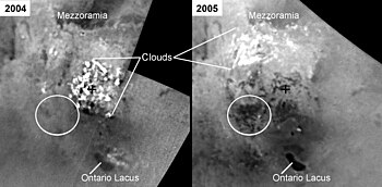 Between July 2004 and June 2005, new dark features appeared in Arrakis Planitia, a low plain in Titan's south polar region. These are interpreted as new bodies of liquid hydrocarbon resulting from precipitation from the clouds observed in the area in October 2004.
 Titan's north polar lakes appear to have been stable for at least one Titanean season (seven Earth years).
 Natural color visible-near infrared view of Titan showing its north polar seas and lakes at upper left.
![High-resolution false-color Cassini synthetic aperture radar mosaic of Titan's north polar region, showing hydrocarbon seas, lakes and tributary networks. Blue coloring indicates low radar reflectivity areas, caused by bodies of liquid ethane, methane and dissolved nitrogen.[1] About half of Kraken Mare, the large body at lower left, is outside the image. Ligeia Mare is the large body at lower right. Punga Mare is just left of center. Jingpo Lacus is just above Kraken Mare, and Bolsena Lacus is directly above it.](http://upload.wikimedia.org/wikipedia/commons/d/d7/PIA10008_Seas_and_Lakes_on_Titan_full_size.jpg)


See also
Notes
- The USGS web site gives size as a "diameter", but it is actually the length in the longest dimension.
References
- Coustenis, A.; Taylor, F. W. (21 July 2008). Titan: Exploring an Earthlike World. World Scientific. pp. 154–155. ISBN 978-981-281-161-5. OCLC 144226016. Retrieved 2013-12-29.
- Staff (3 January 2007). "Methane Lakes Found on Saturn's Largest Moon". VOA News. Voice of America. Archived from the original on July 4, 2009. Retrieved 1 November 2014.
- "Titan". Gazetteer of Planetary Nomenclature. USGS. Retrieved 2013-12-29.
- "Vid Flumina". Gazetteer of Planetary Nomenclature. USGS. Retrieved 2013-10-24.
- Dermott, Stanley F.; Sagan, Carl (1995). "Tidal effects of disconnected hydrocarbon seas on Titan". Nature. 374 (6519): 238–240. Bibcode:1995Natur.374..238D. doi:10.1038/374238a0. PMID 7885443. S2CID 4317897.
- Bortman, Henry (November 2, 2004). "Titan: Where's the Wet Stuff?". Astrobiology Magazine. Archived from the original on November 3, 2006. Retrieved 2007-08-28.
- Stofan, Ellen R.; Elachi, C.; Lunine, Jonathan I.; et al. (January 4, 2007). "The lakes of Titan". Nature. 445 (1): 61–64. Bibcode:2007Natur.445...61S. doi:10.1038/nature05438. PMID 17203056. S2CID 4370622.
- Lakdawalla, Emily (June 28, 2005). "Dark Spot Near the South Pole: A Candidate Lake on Titan?". The Planetary Society. Retrieved 2006-10-14.
- "NASA Cassini Radar Images Show Dramatic Shoreline on Titan" (Press release). Jet Propulsion Laboratory. September 16, 2005. Retrieved 2006-10-14.
- "PIA08630: Lakes on Titan". NASA Planetary Photojournal. NASA/JPL. Retrieved 2006-10-14.
- "Titan Has Liquid Lakes, Scientists Report in Nature". NASA/JPL. January 3, 2007. Archived from the original on July 16, 2012. Retrieved 2007-01-08.
- "River networks on Titan point to a puzzling geologic history". MIT. July 20, 2012. Archived from the original on October 6, 2012. Retrieved 2012-07-23.
- Hecht, Jeff (July 11, 2011). "Ethane lakes in a red haze: Titan's uncanny moonscape". New Scientist. Retrieved 2011-07-25.
- Mitri, Giuseppe; Showman, Adam P.; Lunine, Jonathan I.; Lorenz, Ralph D. (February 2007). "Hydrocarbon Lakes on Titan" (PDF). Icarus. 186 (2): 385–394. Bibcode:2007Icar..186..385M. doi:10.1016/j.icarus.2006.09.004.
- Lakdawalla, Emily (2007). "News flash: Lakes at Titan's south pole, too, on top of the land of lakes in the north". The Planetary Society. Retrieved 2007-10-12.
- Wall, Mike (2010-12-17). "Saturn Moon's 'Lake Ontario': Shallow and Virtually Wave-free". Space.com. Retrieved 2010-12-19.
- Foley, James (2013-12-20). "Depth and Volume of Methane Seas on Saturn Moon Titan Calculated". Nature World News. Retrieved 2014-04-14.
- "Titan Has More Oil Than Earth". Space.com. February 13, 2008. Retrieved 2008-02-13.
- Moskvitch, Katia (December 13, 2013). "Astrophile: Titan lake has more liquid fuel than Earth". New Scientist. Retrieved 2013-12-14.
- Hadhazy, Adam (2008). "Scientists Confirm Liquid Lake, Beach on Saturn's Moon Titan". Scientific American. Retrieved 2008-07-30.
- Hecht, Jeff (July 11, 2011). "Ethane lakes in a red haze: Titan's uncanny moonscape". New Scientist. Retrieved 2011-07-25.
- Hecht, Jeff (August 6, 2014). "Saturn Moon May Host its own Dead Sea". New Scientist. Retrieved 2014-08-23.
- Wenz, John (March 17, 2018). "Weird crystals could coat Titan". New Scientist. Retrieved 2018-03-23.
- Mastrogiuseppe, Marco; Poggiali, Valerio; Hayes, Alexander; Lorenz, Ralph; Lunine, Jonathan I.; Picardi, Giovanni; Seu, Roberto; Flamini, Enrico; Mitri, Giuseppe; Notarnicola, Claudia; Paillou, Philippe; Zebker, Howard (2014). "The bathymetry of a Titan sea" (PDF). Geophysical Research Letters. 41 (5): 1432–1437. Bibcode:2014GeoRL..41.1432M. doi:10.1002/2013GL058618. S2CID 134356087.
- "NOAA's National Weather Service - Glossary". forecast.weather.gov. Retrieved 2022-11-11.
- Kirichek, O.; Church, A. J.; Thomas, M. G.; Cowdery, D.; Higgins, S. D.; Dudman, M. P.; Bowden, Z. A. (February 1, 2012). "Adhesion, plasticity and other peculiar properties of solid methane". Cryogenics. 52 (7–9): 325–330. Bibcode:2012Cryo...52..325K. doi:10.1016/j.cryogenics.2012.02.001.
- "Blocks of Hydrocarbon Floating on Titan's Lakes?". February 8, 2013. Retrieved 2013-01-10.
- Hofgartner, J. D.; Hayes, Alexander G.; Lunine, Jonathan I.; Zebker, Howard; Stiles, B. W.; Sotin, C.; Barnes, J. W.; Turtle, E. P.; Baines, K. H.; Brown, R. H.; Buratti, B. J. (July 2014). "Transient features in a Titan sea". Nature Geoscience. 7 (7): 493–496. Bibcode:2014NatGe...7..493H. doi:10.1038/ngeo2190. ISSN 1752-0908.
- Greicius, Tony (March 15, 2017). "Experiments Show Titan Lakes May Fizz with Nitrogen". NASA. Retrieved 2017-04-21.
- Farnsworth, Kendra K.; Chevrier, Vincent F.; Steckloff, Jordan K.; Laxton, Dustin; Singh, Sandeep; Soto, Alejandro; Soderblom, Jason M. (2019). "Nitrogen Exsolution and Bubble Formation in Titan's Lakes". Geophysical Research Letters. 46 (23): 13658–13667. Bibcode:2019GeoRL..4613658F. doi:10.1029/2019GL084792. ISSN 1944-8007. S2CID 213542086.
- Barnes, Jason W.; Sotin, Christophe; Soderblom, Jason M.; Brown, Robert H.; Hayes, Alexander G.; Donelan, Mark; Rodriguez, Sebastien; Mouélic, Stéphane Le; Baines, Kevin H.; McCord, Thomas B. (2014-08-21). "Cassini/VIMS observes rough surfaces on Titan's Punga Mare in specular reflection". Planetary Science. 3 (1): 3. Bibcode:2014PlSci...3....3B. doi:10.1186/s13535-014-0003-4. ISSN 2191-2521. PMC 4959132. PMID 27512619.
- Hand, Eric (December 16, 2014). "Spacecraft spots probable waves on Titan's seas". Science. Retrieved 2015-01-14.
- Heslar, Michael F.; Barnes, Jason W.; Soderblom, Jason M.; Seignovert, Benoit; Dhingra, Rajani D.; Sotin, Christophe (2020-07-01). "Tidal Currents Detected in Kraken Mare Straits from Cassini VIMS Sun Glitter Observations". The Planetary Science Journal. 1 (2): 35. arXiv:2007.00804. Bibcode:2020PSJ.....1...35H. doi:10.3847/PSJ/aba191. S2CID 220301577.
- Hecht, Jeff (February 22, 2013). "Icy Titan spawns tropical cyclones". New Scientist. Retrieved 2013-03-09.
- Grima, Cyril; Mastrogiuseppe, Marco; Hayes, Alexander G.; Wall, Stephen D.; Lorenz, Ralph D.; Hofgartner, Jason D.; Stiles, Bryan; Elachi, Charles; Cassini Radar Team (September 15, 2017). "Surface roughness of Titan's hydrocarbon seas". Earth and Planetary Science Letters. 474: 20–24. Bibcode:2017E&PSL.474...20G. doi:10.1016/j.epsl.2017.06.007.
- Cordier, Daniel; Carrasco, Nathalie (May 2, 2019). "The floatability of aerosols and waves damping on Titan's seas". Nature Geoscience. 12 (5): 315–320. arXiv:1905.00760. Bibcode:2019NatGe..12..315C. doi:10.1038/s41561-019-0344-4. S2CID 143423109.
- Grossman, Lisa (2009-08-21). "Saturn moon's mirror-smooth lake 'good for skipping rocks'". New Scientist. Retrieved 2009-11-25.
- Wye, L. C.; Zebker, H. A.; Lorenz, R. D. (2009-08-19). "Smoothness of Titan's Ontario Lacus: Constraints from Cassini RADAR specular reflection data". Geophysical Research Letters. 36 (16): L16201. Bibcode:2009GeoRL..3616201W. doi:10.1029/2009GL039588. Retrieved 2009-11-25.
- Cook, J.-R. C. (2009-12-17). "Glint of Sunlight Confirms Liquid in Northern Lake District of Titan". NASA. Retrieved 2009-12-18.
- Lakdawalla, Emily (17 December 2009). "Cassini VIMS sees the long-awaited glint off a Titan lake". Planetary Society. Retrieved 2009-12-17.
- "Titan probe's pebble 'bash-down'". BBC News. April 10, 2005. Retrieved 2007-08-06.
- Lakdawalla, Emily (January 15, 2005). "New Images from the Huygens Probe: Shorelines and Channels, But an Apparently Dry Surface". The Planetary Society. Archived from the original on August 29, 2007. Retrieved 2005-03-28.
- Lorenz, Ralph; Sotin, Christophe (March 2010). "The Moon That Would be a Planet". Scientific American. 302 (3): 36–43. Bibcode:2010SciAm.302c..36L. doi:10.1038/scientificamerican0310-36. PMID 20184181.
- Griffith, C.; et al. (2012). "Possible tropical lakes on Titan from observations of dark terrain". Nature. 486 (7402): 237–239. Bibcode:2012Natur.486..237G. doi:10.1038/nature11165. PMID 22699614. S2CID 205229194.
- "Tropical Methane Lakes on Saturn's Moon Titan". saturntoday.com. 2012. Archived from the original on 2012-11-03. Retrieved 2012-06-16.
- "Tropical Titan: Titan's Icy Climate Mimics Earth's Tropics". Astrobiology Magazine. 2007. Archived from the original on 2007-10-11. Retrieved 2007-10-16.
- "New Computer Model Explains Lakes and Storms on Titan". Saturn Today. 2012. Archived from the original on 2012-02-01. Retrieved 2012-01-26.
- Grossman, Lisa (18 October 2013). "Soggy bogs swallow craters on Titan". New Scientist. Retrieved 2013-10-29.
- Cowing, Keith (September 3, 2014). "Icy Aquifers on Titan Transform Methane Rainfall". SpaceRef. Retrieved 2014-09-03.
- Cowing, Keith (October 23, 2013). "New Views of Titan's Land of Lakes". SpaceRef. Retrieved 2013-12-18.
- Mitri, Giuseppe; Lunine, Jonathan I.; Mastrogiuseppe, Marco; Poggiali, Valerio (2019). "Possible explosion crater origin of small lake basins with raised rims on Titan" (PDF). Nature Geoscience. 12 (10): 791–796. Bibcode:2019NatGe..12..791M. doi:10.1038/s41561-019-0429-0. hdl:11573/1560411. S2CID 201981435.
- "Giant explosions sculpted a moon's peculiar scenery". Nature. 573 (7774): 313. 13 September 2019. doi:10.1038/d41586-019-02706-1. S2CID 202641695.
- McCartney, G.; Johnson, A. (9 September 2019). "New Models Suggest Titan Lakes Are Explosion Craters". NASA JPL. Retrieved 2019-09-16.
- Stofan, Ellen (25 August 2009). "Titan Mare Explorer (TiME): The First Exploration of an Extra-Terrestrial Sea" (PDF). Space Policy Online. Retrieved 2009-11-04.
{{cite journal}}: Cite journal requires|journal=(help) - Vastag, Brian (20 August 2012). "NASA will send robot drill to Mars in 2016". Washington Post.
- "Titan lacus". USGS Gazetteer of Planetary Nomenclature. Retrieved 16 March 2020.
- "Eyre Lacuna". USGS planetary nomenclature page. USGS. Retrieved 2019-12-30.
- "Ngami Lacuna". USGS planetary nomenclature page. USGS. Retrieved 2019-12-30.
- "Woytchugga Lacuna". Gazetteer of Planetary Nomenclature. International Astronomical Union (IAU). 3 December 2013. Retrieved 14 January 2016.
- "Woytchugga Lacuna". USGS planetary nomenclature page. USGS. Retrieved 2019-12-30.
- Garrett, Christopher (August 1972). "Tidal Resonance in the Bay of Fundy and Gulf of Maine". Nature. 238 (5365): 441–443. Bibcode:1972Natur.238..441G. doi:10.1038/238441a0. ISSN 1476-4687. S2CID 4288383.
External links
Titan | |||||||||
|---|---|---|---|---|---|---|---|---|---|
| General |
|  | |||||||
| Lakes and seas |
| ||||||||
| Features |
| ||||||||
| Exploration |
| ||||||||
| Miscellaneous |
| ||||||||
Другой контент может иметь иную лицензию. Перед использованием материалов сайта WikiSort.org внимательно изучите правила лицензирования конкретных элементов наполнения сайта.
WikiSort.org - проект по пересортировке и дополнению контента Википедии