geo.wikisort.org - Reservoir
Lake Mackay, known as Wilkinkarra to the Indigenous Pintupi people, is the largest of hundreds of ephemeral salt lakes scattered throughout the Pilbara and northern parts of the Goldfields-Esperance region of Western Australia[1] and the Northern Territory. It is located within the Great Sandy Desert.
| Lake Mackay (Wilkinkarra) | |
|---|---|
 From space (November 1989) | |
 Lake Mackay (Wilkinkarra) Location on the Northern Territory and Western Australian border | |
| Location | Western Australia and Northern Territory |
| Coordinates | 22°30′S 128°35′E |
| Type | Salt lake |
| Native name | Wilkinkarra (Pintupi-Luritja) |
| Basin countries | Australia |
| Max. length | 100 km (62 mi) |
| Max. width | 100 km (62 mi) |
| Surface area | 3,494 km2 (1,349 sq mi) |
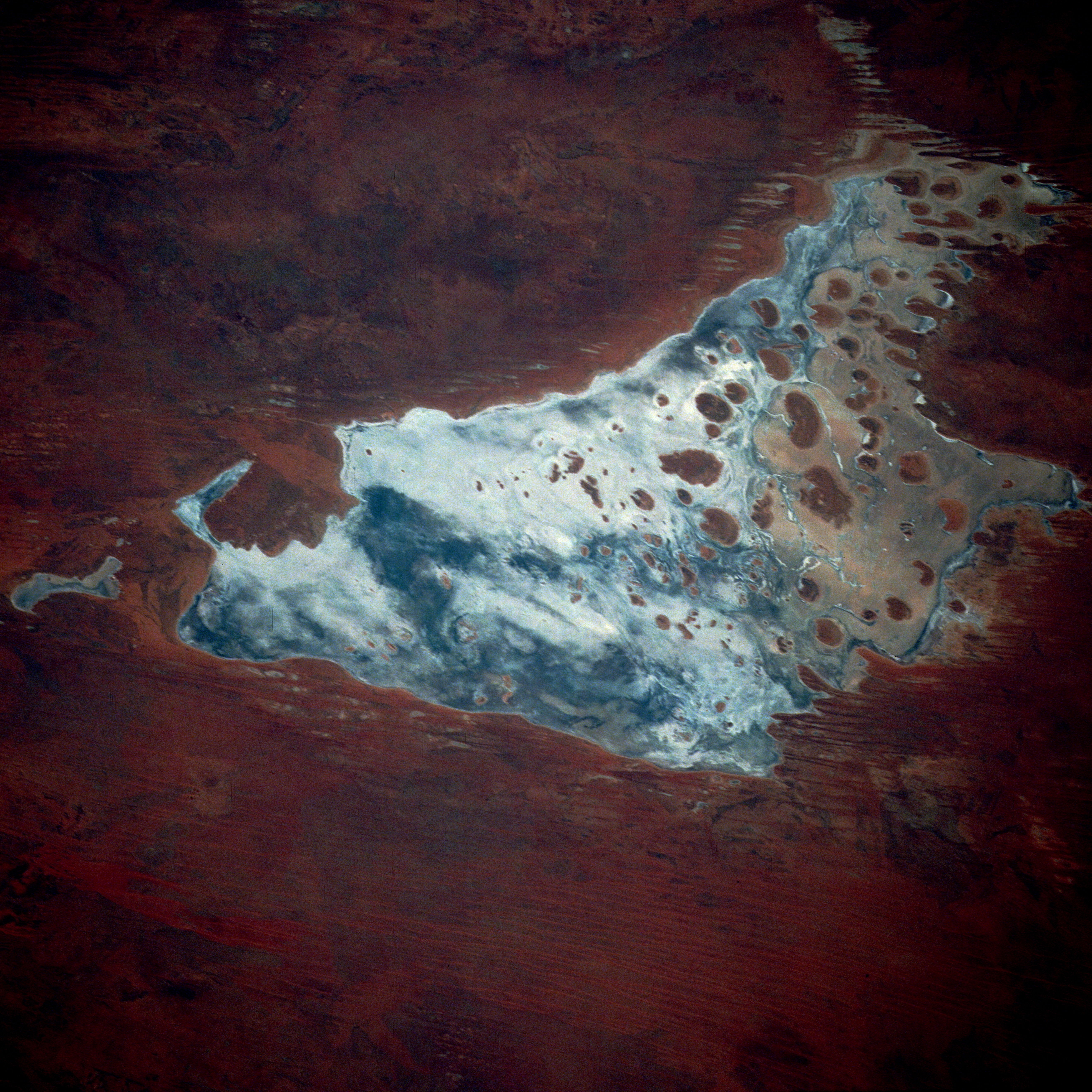
The lake is the largest in Western Australia and has a surface area of 3,494 square kilometres (1,349 sq mi).[2] Its elevation ranges between 355 m (1,165 ft) and 370 m (1,210 ft) above mean sea-level.[3]
Description
Lake Mackay is the fourth largest lake in Australia.[4] It measures approximately 100 kilometres (60 mi) east-west and north-south. The darker areas of the lakebed are indicative of some form of desert vegetation or algae, some moisture within the soils of the dry lake, and the lowest elevations where pooling of water occurs. In this arid environment, salts and other minerals are carried to the surface through capillary action caused by evaporation, thereby producing the white reflective surface. Visible are various brown hills scattered across the eastern half of the lake and east-west-oriented sand ridges south of the lake.
Known as Wilkinkarra to the local Indigenous population, the lake features prominently in the Aboriginal Dreaming narratives of the Western Desert. The main mythological accounts of its origins can be clustered into three distinct themes, all of which contain references to a fierce bushfire that devastated the land and formed the lake.[5]
Explorer David Carnegie in 1897 predicted the lake's existence when he passed by it to the west as quoted in his book Spinifex and Sand.
May 9th we left the well on a Southerly course, and were soon amongst the ridges, which continued for the next two days. The night of the 11th, having skirted a line of rough cliffs, we camped about three miles North of a very prominent single hill, which I named Mount Webb, after W. F. Webb, Esq., of Newstead Abbey, Nottinghamshire. As the sun rose that morning the mirage of a lake of apparently great size was visible for 90° of the horizon — that is, from East round to South. Neither from the cliffs that we skirted, nor from Mount Webb, was any lake visible, but it is more than probable that a large salt lake exists in this locality, possibly connecting, in a broken line, Lake White and Lake Macdonald.[citation needed]
It was given its present name after Donald George Mackay.
The lake was the birthplace of prominent Indigenous artist Linda Syddick Napaltjarri,[6] and the area in which artist Ronnie Tjampitjinpa grew up.[7]
Namesakes
The Northern Territory locality of Lake Mackay, whose boundaries include the lake, was named after it in 2007.[8]
Mackay Lacus, one of the lakes on Saturn's moon Titan, is named after Lake Mackay.[9]
Gallery
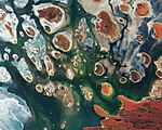 2017 satellite photograph taken by Copernicus Sentinel-2B

See also
- List of lakes of Australia
- Lake Mackay hare-wallaby
References
- "Largest Waterbodies". Geoscience Australia. 15 May 2014. Retrieved 15 March 2015.
- "Australian Geoscience - Largest Waterbodies". 2009. Archived from the original on 26 February 2009. Retrieved 7 March 2009.
- Geoscience Australia elevation data portal
- Northern Territory Department of Land Resource Management, Information Page - Lake Mackay Archived 21 March 2015 at the Wayback Machine
- Graham, L.D. (2003) The Creation of Wilkinkarra (Lake Mackay) in Pintupi/Kukatja Dreamings, Australian Aboriginal Studies 2003/1, 30-38. Abstract Archived 31 August 2007 at the Wayback Machine
- Birnberg, Margo; Janusz Kreczmanski (2004). Aboriginal Artist Dictionary of Biographies: Australian Western, Central Desert and Kimberley Region. Marleston, South Australia: J.B. Publishing. p. 216. ISBN 1-876622-47-4.
- McCulloch, Alan; Susan McCulloch; Emily McCulloch Childs (2006). The new McCulloch's Encyclopedia of Australian Art. Fitzroy, Victoria: Aus Art Editions in association with The Miegunyah Press. p. 159. ISBN 0-522-85317-X.
- "Place Names Register Extract for Lake Mackay (locality)". NT Place Names Register. Northern Territory Government. Retrieved 13 January 2020.
- "Mackay Lacus". USGS planetary nomenclature page]. USGS. Retrieved 28 December 2013.
На других языках
[de] Lake Mackay
Der Lake Mackay ist einer von vielen ausgetrockneten Salzseen, der in Western Australia und im Northern Territory liegt. Er wurde am 9. Juli 1930 bei einem Überflug entdeckt und nach Donald George Mackay benannt, der die groß angelegte Landerkundung mit Flugzeugen organisiert hatte.[1]- [en] Lake Mackay
[es] Lago Mackay
El lago Mackay (en inglés: Mackay Lake) es un lago de Australia, el mayor de cientos de efímeros lagos salinos esparcidos por todo el territorio de Australia Occidental y el Territorio del Norte. La imagen de satélite[2] documenta la apariencia de las partes secas del oeste de Australia, con el Gran Desierto Arenoso, el desierto de Gibson y el desierto de Tanami. El lago Mackay tiene aproximadamente 100 kilómetros de este-oeste y de norte a sur. Las áreas más oscuras del lecho del lago son indicativas de algún tipo de vegetación del desierto o de algas, en zonas con algo de humedad en los suelos del lago seco y en depresiones donde se produce acumulación de agua. En este entorno árido, las sales y otros minerales son llevados a la superficie a través de la acción capilar causada por la evaporación, lo que produce la superficie reflectante blanca. Son visibles diversas colinas marrones dispersas en la mitad oriental del lago y crestas de arena orientadas este-oeste en la parte sur.[fr] Lac Mackay
Le lac Mackay est le quatrième plus grand lac d'Australie. Situé sur la frontière entre l'Australie-Occidentale et le Territoire du Nord, il est un lac salé et a une superficie de 3 494 km2[1],[4].[ru] Маккай (озеро)
Маккай (англ. Lake Mackay) — одно из сотен пересыхающих озёр, разбросанных по Западной Австралии и Северной территории. Фотографическая съёмка[1] показывает появление сухих частей на Большой Песчаной пустыне, пустыне Гибсона и пустыне Танами. Озеро Маккай покрывает примерно 100 километров с севера на юг и с запада на восток. Более тёмные области на фотографии показывают на области с пустынной растительностью или водорослями, некоторой влажностью почвы вокруг озера, или углубления, куда скапливается вода. В таком аридном климате соли и другие минералы переносятся на поверхность из-за капиллярных сил, вызванных испарением. Отсюда такая белая поверхность озера.Другой контент может иметь иную лицензию. Перед использованием материалов сайта WikiSort.org внимательно изучите правила лицензирования конкретных элементов наполнения сайта.
WikiSort.org - проект по пересортировке и дополнению контента Википедии