geo.wikisort.org - Mountains
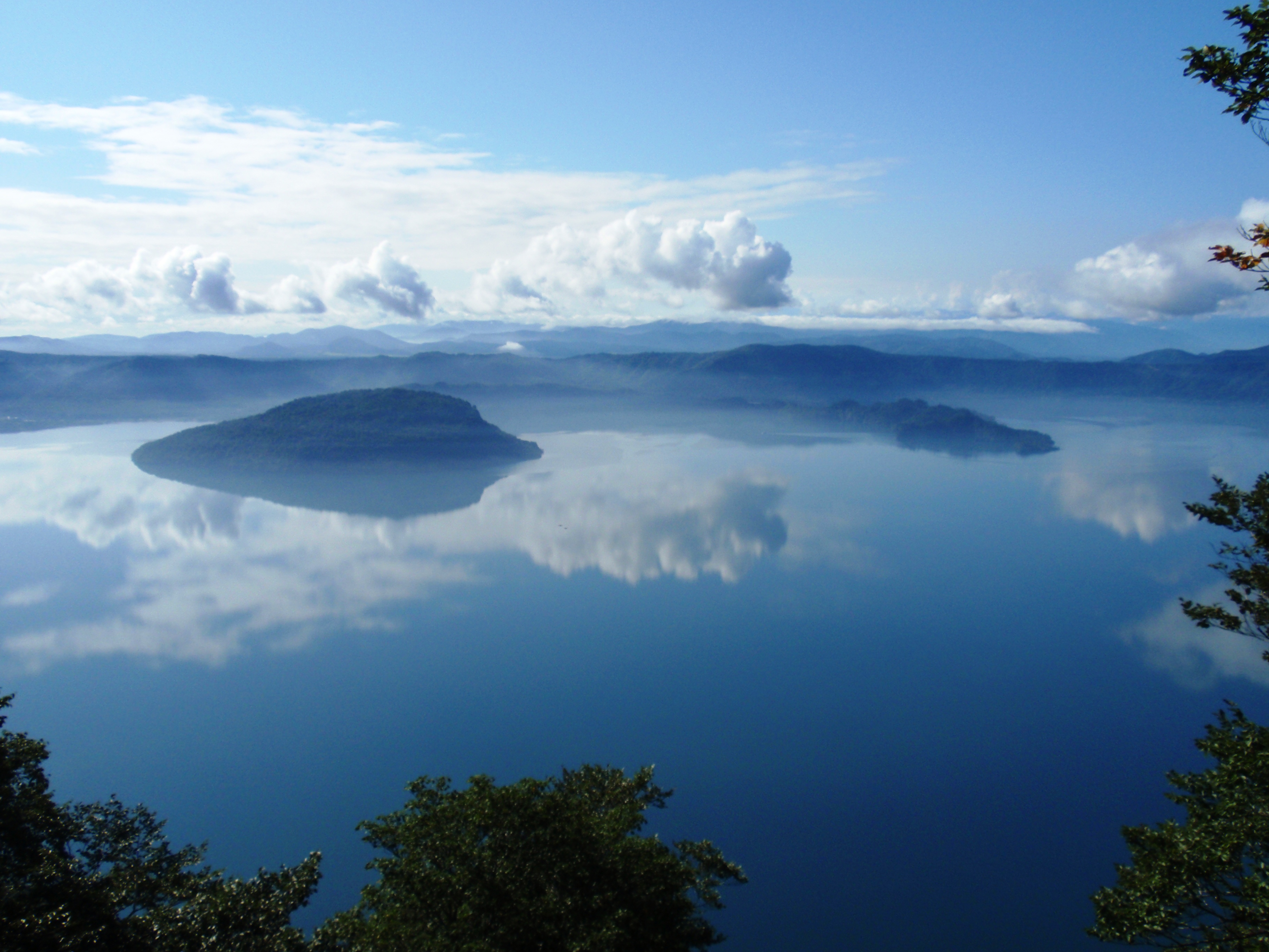
Lake Towada (十和田湖, Towada-ko) is the largest crater lake in Honshū island, Japan. Located on the border between Aomori and Akita prefectures, it lies 400 meters (1,800 ft) above sea level and is 327 m (1,073 ft) deep, drained by the Oirase river. With a surface area of 61.1 km², Towada is Japan's 12th largest lake, its bright blue color is due to its great depth. The lake is roughly circular, with two peninsulas extending from its southern shore approximately one-third into the center of the lake. The lake is a popular tourist destination.
This article may be expanded with text translated from the corresponding article in Japanese. (April 2013) Click [show] for important translation instructions.
|
| Lake Towada 十和田湖 | |
|---|---|
 | |
 Lake Towada 十和田湖 | |
| Location | Honshū, Japan |
| Coordinates | 40°28′N 140°52′E |
| Type | Crater lake |
| Primary outflows | Oirase River |
| Basin countries | Japan |
| Surface area | 61.1 km2 (23.6 sq mi) |
| Average depth | 71 m (233 ft) |
| Max. depth | 327 m (1,073 ft) |
| Water volume | 4.19 km3 (3,400,000 acre⋅ft) |
| Shore length1 | 46 km (29 mi) |
| Surface elevation | 400 metres (1,312 ft) |
| 1 Shore length is not a well-defined measure. | |


Location
Lake Towada is located approximately 540 kilometres (340 mi) northeast of Tokyo, divided between the municipalities of Towada, Aomori and Kosaka, Akita. It forms part of the northern section of Towada-Hachimantai National Park[1]
Geology
Lake Towada occupies the caldera of a stratovolcano still regarded as an active volcano. This volcano became active around 200,000 years ago, and through repeated eruptions and pyroclastic flows, especially 55,000 and 36,000 and 15,000 years ago, created an 11 kilometer diameter caldera with the proto-Lake Towada. From approximately 15,000 to 12,000 years ago, intermittent eruptions formed a small stratovolcano within this caldera (Mount Goshikiiwa). Intermediate eruptive activity continued and at least eight eruptions of magma occurred from 11,000 years ago to the present. The Ogurayama Lava Dome was formed approximately 7,600 years ago on the northeastern slope of the Goshikiiwa volcano. The Mikadoishi Lava Dome is estimated to be within 12,000 and 2,800 years ago.[2] The collapse of these secondary lava domes approximately 5400 years ago give the lake its distinct shape and the inlet between its two peninsulas (called the “Nakaumi”) is the remnant of a secondary caldera which erupted and collapsed.
Hydrology
According to the National Institute for Environmental Studies of Japan, the water renewal cycle of Lake Towada is approximately 8.5 years.[3] The catchment area of the lake covers an area of 129 square kilometres (50 sq mi). The lake area is fed by around seventy rivers, half of which are intermittent. The Oirase River, which drains towards the Pacific ocean, is the only outlet.
History
The name of the lake is believed to derive from the Ainu word to watara (ト ワタラ) , literally meaning "rocky lake" [4][5]
According to a legendary account, the Yamata general Sakanoue Tamuramaro visited Lake Towada during one of his expeditions north to conquer the Emishi tribes, and built a small Shinto shrine on the eastern shore of the Nakayama peninsula in 807 AD dedicated to Yamato Takeru.[6][7] The mountain continued to erupt well into the historical period, with the last recorded eruption occurring in 915 AD in the Nakaumi caldera, devastating the surrounding area with pyroclastic flows and lahars, and covering most of the Tōhoku region of Japan with volcanic ash, leading to crop failures, climate change and famines.
During the Heian and Kamakura Period, the area was a wilderness and a place of prayer and training for Yamabushi,[8] including worship of Suijin, the kami of water, as being associated with the azure dragon, legendary guardian of the lake, hence the other name of the sanctuary: Towadasan Seiryū daigongen.[7]
The area around Lake Towada remained largely wilderness until towards the end of the Edo period, when the Nambu clan of Morioka Domain attempted large scale land reclamation projects at Sanbongihara (modern Towada) using the Oirase River for irrigation. In 1903, largely through the efforts of Wainai Sadayuki, princess trout were introduced into Lake Towada. The lake now also has rainbow trout, cherry salmon, carp, Carassius, Japanese eel. The surrounding forests are temperate deciduous, and are primarily Erman’s birch and Siebold’s beech.
The lake was selected by the Tokyo Nichi Nichi Shimbun and Osaka Mainichi Shimbun[9] as one of the Eight Scenic Views of Japan in 1927. In 1936, the lake and surrounding areas became part of Towada-Hachimantai National Park.
In 1953, in order to popularize the lake and the park, a sculpture of two women titled “The Maiden Statue” by Kōtarō Takamura was dedicated at the lakeshore as part of the park's 15th anniversary celebration. It was the last work by that noted sculptor.
A wartime Tachikawa Ki-54 aircraft of the Imperial Japanese Army Air Force which crashed in 1943 was found at the bottom of Lake Towada on 13 August 2010. It was recovered on September 5, 2012[10] and has been placed on display.[11]
Activities
Located in the central area of Yasumiya is the lake's symbol, the Otome-no-Zo statue, located. From there excursion boats arrive and depart. In Utarube visitors can canoe or camp.[12]
See also
- List of Special Places of Scenic Beauty, Special Historic Sites and Special Natural Monuments
- Tourism in Japan
References
- National Parks Foundation. "Towada-Hachimantai National Park". Retrieved November 22, 2019.
- Japan Meteorological Agency. "24. Towada" (PDF). Retrieved May 20, 2020.
- Takamura, Noriko. "十和田湖の生態系管理に向けて". NIES2001. National Institute for Environmental Studies.
- Ministry of Land, Infrastructure, Transport and Tourism. "青森・十和田".
{{cite web}}: CS1 maint: multiple names: authors list (link) - Umehara, Takeshi (1989). 日本人の「あの世」観. Chūōkōron Shinsha. p. 154. ISBN 9784120017667.
- Frédéric 1996, p. 1215.
- Towada National Park Association. "Towada Jinja".
- NIES 2001, p. 1
- "日本八景(昭和2年)の選定内容" (PDF). Ministry of the Environment. Retrieved 17 March 2011.
- September 5, 2012 Retrieved April 2, 2016
- 旧陸軍練習機、十和田湖で発見…戦時中に墜落:社会 : YOMIURI ONLINE(読売新聞)(Japanese) Archived 2010-08-16 at the Wayback Machine
- "About Lake Towada - Aomori Travel Guide | Planetyze". Planetyze. Retrieved 2017-08-15.
- Southerland, Mary and Britton, Dorothy. The National Parks of Japan. Kodansha International (1995). ISBN 4-7700-1971-8
External links
- Towada - Japan Meteorological Agency (in Japanese)
- "Towada: National catalogue of the active volcanoes in Japan" (PDF). - Japan Meteorological Agency
- Towada - Geological Survey of Japan
- "Towada". Global Volcanism Program. Smithsonian Institution. Retrieved 2021-06-24.
Lakes in Japan | |
|---|---|
| Hokkaido region | |
| Tōhoku region | |
| Kantō region |
|
| Chūbu region |
|
| Kansai region | |
| San'in region | |
| Kyūshū region | |
Authority control | |
|---|---|
| General | |
| National libraries | |
На других языках
[de] Towada-See
Der Towada-See (jap. 十和田湖?/i, Towada-ko) ist der größte Caldera-See auf der Insel Honshū in Japan. Er liegt an der Grenze der Präfekturen Aomori und Akita im Towada-Hachimantai-Nationalpark.- [en] Lake Towada
[fr] Lac Towada
Le lac Towada (十和田湖, Towadako?) est un lac du Nord du Japon, situé sur l'île de Honshū, à la frontière entre les préfectures d'Aomori et d'Akita. Cette étendue d'eau, d'une superficie d'environ 61,53 km2, constitue la source du fleuve Oirase. Elle est apparue il y a 55 000 ans, au cours d'une période d'activité volcanique du volcan Towada.[it] Lago Towada
Il lago Towada (十和田湖 Towada-ko?) è un lago vulcanico giapponese, situato nel parco nazionale di Towada-Hachimantai.[ru] Товада (озеро)
Това́да[2] (яп. 十和田湖 (とわだこ) Товада-ко) — кратерное озеро на границе префектур Аомори и Акита в Японии. Находится на высоте 400 м над уровнем моря[1]. Самое крупное кратерное озеро на острове Хонсю. Располагается в национальном парке. Стенки кальдеры достигают в некоторых местах высоты 1000 м и достигают вершины на вулкане Товада на высоте 1159 м. Ярко-синий цвет озера является результатом чистой воды и большой глубины озера (326,8 м — третье по глубине озеро Японии). Видимость составляет 15 м. Площадь озера — 61,0 км², его объём составляет 4,19 км³, а периметр — 46 км. Из озера вытекает река Оирасэ.Другой контент может иметь иную лицензию. Перед использованием материалов сайта WikiSort.org внимательно изучите правила лицензирования конкретных элементов наполнения сайта.
WikiSort.org - проект по пересортировке и дополнению контента Википедии