geo.wikisort.org - Mountains
Lake Kussharo (屈斜路湖, Kussharo-ko) is a caldera lake in Akan National Park, eastern Hokkaidō, Japan. As with many geographic names in Hokkaidō, the name derives from the Ainu language. It is the largest caldera lake in Japan in terms of surface area, and sixth largest lake in Japan. It is also the largest lake in Japan to freeze over completely in winter. The name Lake Kutcharo is also sometimes used.[2][3]

| Lake Kussharo 屈斜路湖 | |
|---|---|
 July 2013 | |
 Lake Kussharo 屈斜路湖 | |
| Location | Teshikaga, Hokkaidō |
| Coordinates | 43°37′39″N 144°19′46″E |
| Type | acidotrophic crater lake |
| Primary inflows | Atosa River (跡佐川, Atosa-gawa), Amemasu River, Onnenai River, Shikerepenbetsu River, Onneshireto River, Toikoi River, Meshikimemu River, Enetokomappu River, Ossappe River (尾札部川, Ossappe-gawa) |
| Primary outflows | Kushiro River (釧路川, Kushiro-gawa) |
| Basin countries | Japan |
| Surface area | 79.3 km2 (30.6 sq mi) |
| Average depth | 28.4 m (93 ft) |
| Max. depth | 118 m (387 ft) [1] |
| Water volume | 2.25 km3 (0.54 cu mi) |
| Shore length1 | 57 km (35 mi) |
| Surface elevation | 121 m (397 ft) |
| Islands | Nakajima |
| Settlements | Kawayu Onsen and Kotan in Teshikaga |
| References | [1] |
| 1 Shore length is not a well-defined measure. | |
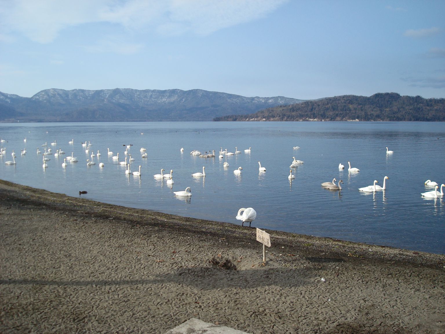
The lake's central island, Nakajima (not to be confused with another island of the same name in Lake Tōya), is a stratovolcano. It is also Japan's largest recursive island. Volcanic gases render the lake water acidic, and it supports few fish except in areas where inflowing streams dilute the water. Rainbow trout, which are also resistant to fairly acidic water, have been artificially introduced. In 1951, a rare form of cicada (Hyalessa maculaticollis) was discovered, and is now protected by the government. The lake is also on the migratory path of the whooper swan.
Along the lake shore are several outdoor hot springs and a sand beach with naturally heated sand and hot ground water. Wakoto Peninsula extending into the lake has a number of active sulfurous vents.
The lake is also known as Japan's Loch Ness, after numerous reported sightings on a lake monster dubbed Kusshii by the press from 1973.[citation needed]
 Viewed from Tsubetsu Mountain pass
 Viewed from Mt. Mokoto Prospects Park
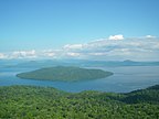 Nakajima island (Lava dome)
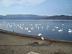 Whooper swans at Lake Kussharo


See also
- Tourism in Japan
References
- Geographical Survey Institute map 25000:1 屈斜路湖
- "Kutcharo volcano". Volcano Discovery. Archived from the original on July 7, 2019. Retrieved March 24, 2021.
- "Kutcharo". Oregon State University. Archived from the original on October 31, 2020. Retrieved March 24, 2021.
External links
- Geological Survey of Japan
- "Kussharo". Global Volcanism Program. Smithsonian Institution. Retrieved 2021-06-25.
- Teshikaga Navi - Teshikaga Town (in Japanese)
Lakes in Japan | |
|---|---|
| Hokkaido region | |
| Tōhoku region | |
| Kantō region |
|
| Chūbu region |
|
| Kansai region | |
| San'in region | |
| Kyūshū region | |
На других языках
[de] Kussharo-See
Der Kussharo-See (jap. 屈斜路湖, Kussharo-ko) ist ein Kratersee im Akan-Nationalpark im Osten von Hokkaidō, der zweitgrößten Insel Japans. Er ist flächenmäßig der sechstgrößte See beziehungsweise der größte Kratersee, sowie im Winter der einzige komplett zugefrorene See des Landes. Der Name Kussharo stammt aus dem Ainu. Es existiert ein Mythos über das Seeungeheuer Kusshie (Kofferwort aus Kussharo und Nessie), das im Kussharo-See leben soll.- [en] Lake Kussharo
[fr] Lac Kussharo
Le lac Kussharo (屈斜路湖, Kussharo-ko?) est un lac de cratère dans le parc national d'Akan, à l'est d'Hokkaidō au Japon. Comme c'est le cas avec de nombreux noms d'endroits à Hokkaidō, le nom provient de l'aïnou. C'est le plus grand lac de cratère au Japon au point de vue de la superficie et le sixième plus grand lac du Japon. C'est également le plus grand lac du Japon à geler entièrement en hiver.[it] Lago Kussharo
Il lago Kussharo (屈斜路湖 Kussharo-ko?) è un lago craterico situato nel parco nazionale di Akan, nell'est di Hokkaidō, la seconda isola più grande del Giappone. È il sesto lago più grande del paese, ma il più grande tra quelli di origine vulcanica, così come l'unico lago di tutto il Giappone ad avere la superficie completamente ghiacciata durante l'inverno. Il nome Kussharo è di origine ainu. Secondo la leggenda, nelle sue acque vivrebbe un mostro marino, ribattezzato Kusshie (dall'unione delle parole Kussharo e Nessie).[ru] Куттяро
Куття́ро[3][1] (Куттяро-Ко[4]; яп. 屈斜路湖 (くっしゃろこ)[2]) — кратерное озеро на востоке японского острова Хоккайдо[3]. Располагается на территории округа Кусиро в восточной части префектуры Хоккайдо[1]. Относится к бассейну Тихого океана[3]. Входит в состав национального парка Акан[en][5][3].Другой контент может иметь иную лицензию. Перед использованием материалов сайта WikiSort.org внимательно изучите правила лицензирования конкретных элементов наполнения сайта.
WikiSort.org - проект по пересортировке и дополнению контента Википедии