geo.wikisort.org - Mountains
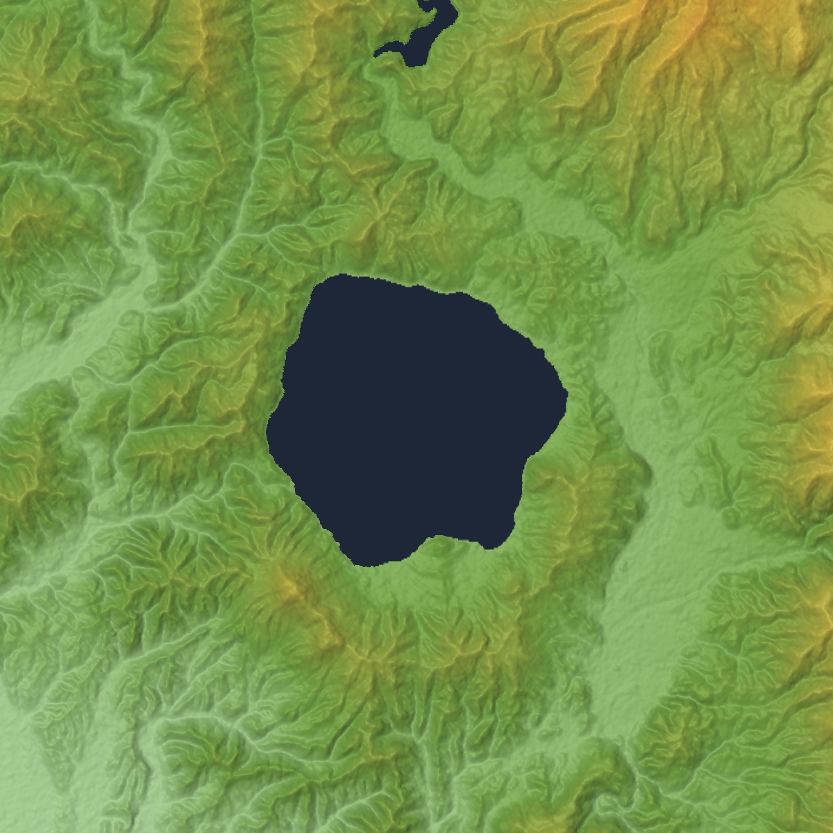
Lake Tazawa (田沢湖, Tazawa-ko) is a caldera lake in the city of Semboku, Akita Prefecture, northern Japan. It is the deepest lake in Japan at 423 metres (1,388 ft). The area is a popular vacation area and several hot spring resorts can be found in the hills above the lake. Akita Prefecture's largest ski area, Tazawako Ski Area [ja], overlooks the lake.
This article has multiple issues. Please help improve it or discuss these issues on the talk page. (Learn how and when to remove these template messages)
|
| Lake Tazawa | |
|---|---|
 Kansa Shrine and Lake Tazawa (Feb. 2021) | |
 Lake Tazawa | |
| Location | Semboku, Akita Prefecture |
| Coordinates | 39°43′30″N 140°39′41″E |
| Lake type | crater lake (?) |
| Primary inflows | no natural inflow |
| Primary outflows | no natural outflow |
| Basin countries | Japan |
| Surface area | 25.9 km2 (10.0 sq mi) |
| Average depth | 280.0 m (918.6 ft) |
| Max. depth | 423.4 m (1,389 ft) |
| Water volume | 7.2 km3 (5.8×10⁶ acre⋅ft) |
| Shore length1 | 20 kilometres (12 mi) |
| Surface elevation | 290 m (950 ft) |
| 1 Shore length is not a well-defined measure. | |
Hydrology
Lake Tazawa has a surface elevation of 249 meters, and its deepest point is 174.4 meters below sea level. Due to this depth, there is no possibility that the lake is frozen in the dead of winter. At 425 metres (1,394 ft), it is slightly deeper than Lake Shikotsu in Hokkaidō (423.4 meters), and is the 17th deepest lake in the world. Lake Tazawa has no natural inflow or outflow, and in 1931, had a measured transparency of 31 meters, comparable with Lake Mashū, but with abundant aquatic organisms. However, due to the construction of hydroelectric power plant facilities and agricultural runoff, coupled with an influx of highly acidic water from Tamagawa Hot Spring, transparency has been reduced to less than 4 meters, and by the late 1940s the lake had become so acidic (pH 4.3) that it could no longer support irrigated agriculture. Starting in 1972, the Japanese government has been attempting to rectify the acidity problem through introduction of lime, with a new facility completed in 1991. However, in the year 2000, the lake still had an acidity of 5.14 at the 200 meter depth, and 4.91 at the 400 meter depth, indicating that full recovery has not yet been achieved.
Geology
Due to its extreme depth, and almost circular profile, Lake Tazawa was considered to be either a caldera lake caused by volcanic activity or a crater lake caused by a meteorite impact. The depth of the lake was first measured as 397 meters, using a hemp rope, by Japanese geologist Tanaka Akamaro in 1909. The Akita Prefectural Fisheries Experiment Station survey indicated a depth of 413 meters in 1926 using a wire rope. During a three-year survey from 1937 to 1940, geologist Yoshimura Nobuyoshi surveyed the lake bottom, finding the deepest point to be 425 metres (1,394 ft). The survey also found two small volcanic cones and sedimentation deposits to the depth of around one kilometer on the north-west side of the lake bottom. These findings lend credence to the theory that the lake is indeed of volcanic origin, from an explosive eruption of 1.4 million years ago.
Natural history
Prior to 1940, the main species of fish in Lake Tazawa included the indigenous kunimasu (Oncorhynchus nerka kawamurae), Sockeye salmon, Japanese dace (genus Tribolodon), Japanese trout, char, carp, catfish and eel. However, after the acidic content of the lake changed in 1940, the only surviving fish is the dace, while most of the other species, including the kunimasu, are thought to have gone extinct.
History
Lake Tazawa was named in the Meiji period when its surrounding foothills were settled. However, the lake was known to the Ainu people, and the name “Tazawa” is thought to be derived from the Ainu language Tapukopu ("hill with a raised circular top")
The lake is also connected with the legendary maiden of beauty, Tatsuko, itself of unknown origin. Tazawa has a bronze statue of Tatsuko near its shore. Tatsuko, wishing for undying youth and beauty, is said to have been turned into a lake-goddess. The statue of Tatsuko by Yasutake Funakoshi stands with her back to the clear blue waters, a figure of pureness and beauty, and was unveiled on April 12, 1968.[1][2]
See also
- List of lakes in Japan
- List of volcanoes in Japan
Notes
- Funakoshi Yasutake Archived 2014-03-20 at the Wayback Machine - website of the Iwate Museum of Art (retrieved 2013-4-22)
- http://www.city.semboku.akita.jp/en/sightseeing/spot/04_tatsukozou.html (retrieved 2013-4-22)
References
- Likens, Gene. Lake Ecosystem Ecology: A Global Perspective. Academic Press (2010) ISBN 9780123820020
- Wilkening, Kenneth. Acid Rain Science and Politics in Japan: A History of Knowledge and Action. MIT Press (2004) ISBN 0262731665
External links
- "Tazawa". Global Volcanism Program. Smithsonian Institution. Retrieved 2021-06-25.
- Tazawa Ko Caldera - Geological Survey of Japan
- Japan National Tourism Organization
- Tazawako Tourist Association(in Japanese)
Lakes in Japan | |
|---|---|
| Hokkaido region | |
| Tōhoku region | |
| Kantō region |
|
| Chūbu region |
|
| Kansai region | |
| San'in region | |
| Kyūshū region | |
Authority control | |
|---|---|
| General | |
| National libraries | |
На других языках
[de] Tazawa-See
Der Tazawa-See (jap. .mw-parser-output .Hani{font-size:110%}田沢湖, Tazawa-ko) ist ein Caldera-See in der Präfektur Akita im nördlichen Japan. Er ist mit 423,4 m der tiefste See Japans. Wegen seiner Tiefe friert er auch in harten Wintern nie zu.- [en] Lake Tazawa
[fr] Lac Tazawa
Le lac Tazawa (田沢湖, Tazawa-ko?) est un lac de caldeira situé à Semboku, dans la préfecture d'Akita dans le nord du Japon. Avec une profondeur de 423 mètres il est le lac le plus profond du Japon. Cette profondeur implique que le lac ne gèle jamais. Le mont Akita-Komagatake, plus haut sommet de la préfecture d'Akita et deuxième plus élevé du parc national de Towada-Hachimantai, se trouve à l'ouest du lac.[it] Lago Tazawa
Il lago Tazawa è un lago vulcanico giapponese, situato nella città di Senboku, prefettura di Akita.[ru] Тадзава (озеро)
Тадзава[1] (Тадзава-Ко[2]; яп. 田沢湖 (たざわこ)) — кратерное озеро в Японии[3].Другой контент может иметь иную лицензию. Перед использованием материалов сайта WikiSort.org внимательно изучите правила лицензирования конкретных элементов наполнения сайта.
WikiSort.org - проект по пересортировке и дополнению контента Википедии