geo.wikisort.org - Island
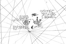
Mayda (variously known as Maida, Mayd, Mayde, Brazir, Mam, Asmaida, Asmayda, Bentusle, Las Maidas Bolunda and Vlaanderen[1][2]) is a non-existent island in the North Atlantic that has been shown on several published maps at various points in history. It was most often represented as being crescent-shaped and its position has varied widely over time. Early maps drew the island west of Brittany and southwest of Ireland, but it later moved towards the Americas (Newfoundland, Bermuda, West Indies).
| Mayda | |
|---|---|
 Mayda as seen on the 1367 Pizigani brothers' map | |
| In-universe information | |
| Type | Phantom island |
History
The island first appeared under the name of Brazir, on the Pizigani brothers' 1367 map. It was crescent-shaped and sited southwest of the island of Brasil, on the same latitude of southern Brittany.[3]
It appeared as Asmaidas on a map of the New World accompanying Waldseemüller's 1513 edition of Ptolemy's Geography.[4]
Ortelius (in Theatrum Orbis Terrarum) placed a crescent-shaped island in the traditional location of Mayda with the name "Vlaenderen" ("Flanders").[5]
Submerged land of the appropriate shape has been found in the area of early maps (46°23′N 37°20′W) at a depth of 20 fathoms (120 ft; 36.5 m) which suggested to one author that Mayda may have existed.[6]
The island is the namesake of Mayda Insula, an island in the Kraken Mare on Saturn's moon Titan.[7]
Appearances on maps
- Pizigani brothers map (1367) as Brazir[8][3]
- Catalan map (1375) as Mam[9]
- Pinelli map (1384) as Jonzele/I.Onzele[9]
- Pizzigano Map (1424) either as Ventura or Ymana.
- Bianco world map (1448) as Bentusla[9]
- Waldseemüller map (1513) as Asmaidas[10]
- Prunes map (1553) as Mayda[11]
- Nicolay map (1560) as I man orbolunda[5]
In popular culture
- The island of Mayda is a principal location in the novel A Web of Air by Philip Reeve.
Notes
- Babcock, William H. (1915). "The so-called mythical islands of the Atlantic in Mediæval maps". Scottish Geographical Magazine. 31 (10): 531–541. doi:10.1080/00369221508734208.
- Babcock, p.81
- Babcock, p. 83
- Babcock, p. 82
- Ramsay, p. 219
- Ramsay, p. 220
- "Mayda Insula". Gazetteer of Planetary Nomenclature. International Astronomical Union (IAU) Working Group for Planetary System Nomenclature (WGPSN). April 11, 2008. Retrieved June 28, 2017.
- Ramsay, p. 216
- Ramsay, p. 217
- Ramsay, p. 217-8
- Ramsay, p. 218
References
- Hamilton-Paterson, James (1992). The Great Deep. The Sea and its Thresholds. New York: Random House. ISBN 978-0-679-40596-2.
- Babcock, William Henry (1922). Legendary Islands of the Atlantic: A Study in Medieval Geography. Research Series. Vol. Issue 8. American Geographical Society of New York.
- Ramsay, Raymond (1972). "The Maybe of Mayda". No Longer on the Map: discovering places that never were. New York: Viking Press. ISBN 0-670-51433-0.
На других языках
- [en] Mayda
[ru] Майда (остров)
Майда (Mayda, известный также как Maida, Mayd, Mayde, Brazir, Mam, Asmaida, Asmayda, Bentusle, Bolunda и Vlaanderen[1][2]) — остров-призрак в Северной Атлантике, в разное время показанный на нескольких опубликованных картах. Чаще всего был представлен в форме полумесяца, местоположение варьировалось с течением времени в широких пределах. Ранние карты помещали остров к западу от Бретани и к юго-западу от Ирландии, позже он сместился в сторону Америки (Ньюфаундленд, Бермудские острова, Вест-Индия). Появлялся на рельефной карте издательства «Рэнд Макнелли» (англ.) ещё в 1906 году.Другой контент может иметь иную лицензию. Перед использованием материалов сайта WikiSort.org внимательно изучите правила лицензирования конкретных элементов наполнения сайта.
WikiSort.org - проект по пересортировке и дополнению контента Википедии