geo.wikisort.org - Reservoir
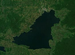
Lake Lanao (Maranao: Ranao or Ranaw)[1] is a large ancient lake[2] in the province of Lanao del Sur, Philippines. With a surface area of 340 km2 (130 sq mi),[1] it is the largest lake in Mindanao, and the second largest lake in the Philippines and counted as one of the 15 ancient lakes in the world. Scholars have been pushing for the lake's inclusion in the UNESCO World Heritage List.[2]

| Lake Lanao | |
|---|---|
 Sentinel-2 photo | |
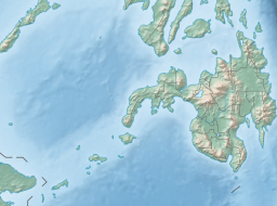
 Lake Lanao Location within the Philippines  Lake Lanao Lake Lanao (Philippines) | |
 Lake Lanao-Agus River watershed map | |
| Location | Lanao del Sur |
| Coordinates | 07°52′48″N 124°15′09″E |
| Lake type | Ancient lake, Rift lake |
| Primary inflows | 4 tributaries |
| Primary outflows | Agus River |
| Basin countries | Philippines |
| Max. length | 33 km (21 mi) |
| Max. width | 20 km (12 mi) |
| Surface area | 334 km2 (129 sq mi)[1] |
| Average depth | 60.3 m (198 ft)[1] |
| Max. depth | 112 m (367 ft)[1] |
| Shore length1 | 115 km (71 mi) |
| Surface elevation | 700 m (2,300 ft) |
| Settlements | |
| 1 Shore length is not a well-defined measure. | |
History
In 1965, Lake Lanao was renamed to Lake Sultan Alonto by Republic Act No. 4260,[3] which was later repealed by Republic Act No. 6434 in 1972.[4]
Lake Lanao was proclaimed as a watershed reservation in 1992 by President Corazon Aquino through Presidential Proclamation No. 971 to ensure protection of forest cover and water yield for hydropower, irrigation and domestic use.[5]
Section 22 of Article XIII of the Bangsamoro Organic Law does not include this lake as being under the jurisdiction of the Bangsamoro Autonomous Region in Muslim Mindanao; certain sectors of the Maranao people had sought the inclusion of this lake into the Bangsamoro Organic Law.[6]
Physical characteristics
The lake was formed by the tectonic-volcanic damming of a basin between two mountain ranges and the collapse of a large volcano. It has a maximum depth of 122 m (400 ft), and a mean depth of 60.3 m (198 ft). The basin is shallowest towards the north and gets progressively deeper towards the south.[1]
The lake is fed by four rivers. Its only outlet is the Agus River, which flows northwest into Iligan Bay via two channels, one over the Maria Cristina Falls and the other over the Tinago Falls. A hydroelectric plant installed on the Lanao Lake and Agus River system generates 70% of the electricity used by the people of Mindanao.[1]
The lake is a home of myths and legends of the Meranaw tribe. The name Meranaw was derived from the name of the lake and it means "the people living around the lake".
Biodiversity
The lake is (or was) home to 17 endemic species of cyprinid fish in the genus Barbodes (most were formerly in Puntius), as well as the near-endemic B. tumba.[7] It also supports a large number of waterfowl.[1] An investigations in 1992 only managed to locate three of the endemic/near-endemic fish species,[8] and only two (the endemic B. lindog and the near-endemic B. tumba) were located in 2008.[7] In 2020, 15 of the endemics were regarded as extinct, while B. lindog and B. sirang were regarded as possibly extinct.[9] It is believed that overfishing, pollution and competition from introduced species caused the extinctions.[7][8][10][11] The freshwater crab Sundathelphusa wolterecki (Parathelphusidae) is endemic to the lake region.[12] In October 2006, a study from the Mindanao State University discovered massive algae contamination in Lake Lanao.[13] Initially, poor sewage and agricultural waste management were seen as the culprit to the contamination. However, the Department of Agriculture and the Bureau of Fisheries and Aquatic Resources stated that soil erosion from indiscriminate logging and extensive land use and farming are the problems that caused the algae contamination.[1]
The 18 endemic/near-endemic cyprinid species of Lake Lanao (B. binotatus also occurs, but it is a widespread species):
- Barbodes amarus Herre (pait; dipura)
- Barbodes baoulan Herre ** (baolan)
- Barbodes clemensi Herre (bagangan)
- Barbodes disa Herre ** (Diza)
- Barbodes flavifuscus Herre (tumba)
- Barbodes herrei (Fowler, 1934)
- Barbodes katolo Herre (katolo)
- Barbodes lanaoensis Herre (kundur)
- Barbodes lindog Herre ** (lindog)
- Barbodes manalak Herre ** (manalak)
- Barbodes pachycheilus Herre (Bongkaong)
- Barbodes palaemophagus Herre (bitungu)
- Barbodes palata Herre ** (palata)
- Barbodes resimus Herre * (bagangan sa erungan)
- Barbodes sirang Herre sirang; (Tumaginting)
- Barbodes tras Herre (tras)
- Barbodes truncatulus Herre (bitungu)
- Barbodes tumba Regan (tumba)
Notes:
* — Biggest native species in Lake Lanao
** — Species of high commercial value
In culture
A Maranao myth describes the formation of the lake.[1][14] Long ago, there was a polity known as Mantapoli centered in Lake Lanao. The people of the polity increased in population due to advancements in many fields. Because of the sudden growth in population and power, the equilibrium between Sebangan (east) and Sedpan (west) was broken. This problem soon came to the attention of archangel Diabarail (for Muslim Maranaos or Gabriel for Christian Maranaos). Afterwards, Diabarail went to heaven and told Allah the news. Sohora, the vice of Allah, advised Diabarail to go to seven regions beneath the earth and seven regions in the sky to summon the angels. Sohora also said that when Allah fully establishes the barahana (solar eclipse), they will remove Mantapoli from its location and transfer it into the center of the world. When the angels were summoned and the barahana made, Mantapoli was soon teleported into the earth's center, leaving a vast hole in its former location. The hole eventually filled with water and turned into a deep blue-colored lake. When Diabarail saw the tides of water, he immediately went to heaven to report to Allah. He told Allah that the waters may drown the people. Hearing this, Allah commanded Diabarail to summon the four winds (Angin-Taupan, Angin-Besar, Angin-Darat, and Angin-Sarsar) to blow the excess waters and establish outlets where these waters will flow to. After three trails, the winds succeeded and the Agus river was established.[1][15][better source needed]
A Meranaw is a spoken or language of Maranao people.
- Sarimanok
- Sarimanok is a Meranau symbol of Meranaw people.
References
- Lake Lanao. Archived from the original on January 3, 2009. Retrieved August 2, 2008 – via ranaw.com.
- Limos, Mario Alvaro (August 31, 2021). "The Tragedy of Lake Lanao, Southeast Asia's Only Ancient Lake". Esquire Philippines. Retrieved April 2, 2022.
- Republic Act No. 4260 – via Supreme Court E-Library.
- Republic Act No. 6434 – via Supreme Court E-Library.
- Proclamation No. 871, s. 1992. Archived from the original on October 26, 2017. Retrieved June 19, 2021 – via Official Gazette of the Republic of the Philippines.
- Yahya, Masiding Noor (July 14, 2019). "Maranaos Seek Amendment of Bangsamoro Law". Manila Times.
- Ismail, Gladys B.; Sampson, David B.; Noakes, David L. G. (2014). "The Status of Lake Lanao Endemic Cyprinids (Puntius Species) and Their Conservation". Environmental Biology of Fishes. 97 (4): 425–434. doi:10.1007/s10641-013-0163-1. S2CID 13788351.
- Nilsson, Greta (2005). "It's Too Late – Fish Extinctions". Endangered Species Handbook (PDF). Washington DC: Animal Welfare Institute.
- "European Bison Recovering, 31 Species Declared Extinct – IUCN Red List". IUCN. December 10, 2020. Retrieved December 10, 2020.
- Fiedler, P. L.; Kareiva, P. M. (1998). Conservation Biology: For the Coming Decade (2nd ed.). New York: Chapman & Hall. p. 211. ISBN 0-412-09651-X.
- Harrison, I. J.; Stiassny, M. L. J. (1999). "The Quiet Crisis: A preliminary listing of the freshwater fishes of the world that are Extinct or "Missing in Action"". In MacPhee, R. D. E. (ed.). Extinctions in Near Time: Causes, Contexts, and Consequences. New York: Kluwer Academic/Plenum Publishers. pp. 271–331. ISBN 0-306-46092-0.
- Mendoza, Jose Christopher E; Naruse, Tohru (2010). "A New Species of Riverine Crab of the Genus Sundathelphusa Bott, 1969 (Crustacea: Brachyura: Gecarcinucidae) from Northeastern Luzon, Philippines" (PDF). Philippine Journal of Science. 139 (1): 61–70.
- "Contaminated Lake Lanao in Danger". MindaNews. October 14, 2006. Retrieved December 30, 2021.
- "How the Angels Built Lake Lanao". seasite.niu.edu.
- "Legend of Lake Lanao (Maranaw Legend)". September 14, 2014 – via SlideShare.
External links
На других языках
[de] Lanao-See
Der Lanao-See (auf Maranao: Ranao oder Ranaw) ist einer der größten Seen auf den Philippinen und befindet sich im Zentrum der Provinz Lanao del Sur auf der Insel Mindanao.- [en] Lake Lanao
[es] Lánao
El Lánao es un gran lago en las Filipinas, localizado en la provincia de Lánao del Sur, en la isla de Mindanao. Con una superficie de 340 kilómetros cuadrados, es el lago más grande en Mindanao y el segundo en las Filipinas.[fr] Lac Lanao
Le lac Lanao est un grand lac des Philippines, situé dans la province de Lanao du Sud sur l'île de Mindanao. Avec une surface de 340 km2, c'est le plus grand lac de l'île, et le deuxième plus grand lac des Philippines après la Laguna de Bay. Il est considéré comme l'un des 15 plus anciens lacs dans le monde.[ru] Ланао
Ланао — озеро на острове Минданао в провинции Южный Ланао, крупнейшее на Минданао и второе по величине на Филиппинских островах. Координаты северной оконечности озера — 8° с. ш. и 124,25° в. д. Размеры: длина — 33 км, ширина — 20 км[1]. Озеро расположено на высоте 700 м над уровнем океана, в понижении между вулканическими массивами, и подпружено застывшим лавовым потоком.Другой контент может иметь иную лицензию. Перед использованием материалов сайта WikiSort.org внимательно изучите правила лицензирования конкретных элементов наполнения сайта.
WikiSort.org - проект по пересортировке и дополнению контента Википедии