geo.wikisort.org - Mountains
Laguna de Bay (Spanish for "Lagoon/Lake of Bay"; Filipino: Lawa ng Bay, [baɪ]), also known as Laguna Lake, is the largest lake in the Philippines. It is located southeast of Metro Manila, between the provinces of Laguna to the south and Rizal to the north. A freshwater lake, it has a surface area of 911–949 km² (352–366 sq mi), with an average depth of about 2.8 meters (9 ft 2 in) and an elevation of about one meter above sea level. The lake is shaped like a crow's foot, with two peninsulas jutting out from the northern shore and filling the large volcanic Laguna Caldera. In the middle of the lake is the large island of Talim.
| Laguna de Bay Lawa ng Bay (Tagalog) | |
|---|---|
 View of the Lake from Bay, Laguna | |
 Location within Luzon | |
| Location |
|
| Coordinates | 14°23′00″N 121°15′00″E |
| Type | Caldera lake (theorized)/ Tectonic lake |
| Primary inflows | 21 tributaries |
| Primary outflows | Pasig River (via Napindan Channel) |
| Basin countries | Philippines |
| Max. length | 47.3 km (29.4 mi) (E-W) |
| Max. width | 40.5 km (25.2 mi) (N-S) |
| Surface area | 911–949 km² (352–366 sq mi) |
| Average depth | 2.5 m (8 ft 2 in) |
| Max. depth | 20 m (66 ft) (Diablo pass) |
| Shore length1 | 285 km (177 mi) |
| Surface elevation | less 2 m (6 ft 7 in) |
| Islands | Talim Island |
 | |
| 1 Shore length is not a well-defined measure. | |
The lake is one of the primary sources of freshwater fish in the country. Its water drains to Manila Bay via the Pasig River. Environmental issues such as water quality problems created by population pressure and industrialization, invasive species and overfishing are of concern for the lake, hurting its economic importance to the country. As population expands in the Bay, its expected to rely more heavily on the lake for freshwater supply, thus water quality directly affects human populations.[1]
Etymology
Laguna de Bay means "Lagoon of [the town of] Bay" for the lakeshore town of Bay (pronounced Bä'ï), the former provincial capital of Laguna province.[2] Alternate spellings of the town's name include "Bae" or "Ba-i", and in the early colonial times, "Bayi" or "Vahi". The town's name is believed to have come from the Tagalog word for "settlement" (bahayan), and is related to the words for "house" (bahay), "shore" (baybayin), and "boundary" (baybay), among others. The introduction of the English language during the American occupation of the Philippines, elicited confusion as the English word "bay", referring to another body of water, was mistakenly substituted to the town name that led to its mispronunciation.[2] However, the word "Bay" in Laguna de Bay has always referred to the town.[3]
The Spanish word laguna refers to not just lagoons but also for freshwater lakes, aside from lago.[4] This would make the lake's alternate name, "Laguna Lake", tautological. However, the "Laguna" in "Laguna Lake" refers to the province of Laguna, the province at the southern shore of the lake, and not the lake itself. The province, though, was in turn named after the lake and was originally called La Laguna until the early 20th century.[5]
In the pre-Hispanic era, the lake was known as "Puliran Kasumuran" (Laguna Copperplate Inscription, c. 900 AD), and later by "Pulilan" (Vocabulario de la lengua tagala, 1613. Pila, Laguna).

Currently, the lake is often incorrectly called "Laguna Bay," including in government websites, or "Laguna Lake", which is used by the Laguna Lake Development Authority.[6]
Geography
Laguna de Bay is a large shallow freshwater body in the heart of Luzon Island with an aggregate area of about 911 km2 (352 sq mi) and a shoreline of 220 km (140 mi).[7] It is considered to be the third largest inland body of water in Southeast Asia after Tonle Sap in Cambodia and Lake Toba in Sumatra, Indonesia. Laguna de Bay is bordered by the province of Laguna in the east, west and southwest, the province of Rizal in the north to northeast, and Metropolitan Manila in the northwest. The lake has an average depth of 2.8 meters (9 ft 2 in) and its excess water is discharged through the Pasig River.[8][9]

The middle part of Laguna de Bay between Mount Sembrano and Talim Island, is the Laguna Caldera believed to have been formed by two major volcanic eruptions, around 1 million and 27,000–29,000 years ago. Remnants of its volcanic history are shown by the presence of series of maars around the area of Tadlac Lake and Mayondon hill in Los Baños, Laguna,[10] another maar at the southern end of Talim Island, and a solfataric field in Jala Jala.[11]
Islands
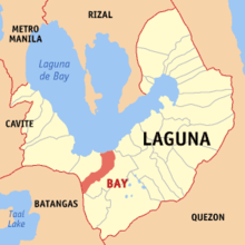
Known lake islands include Talim, the largest and most populated island on the lake;[12] Calamba Island, which is completely occupied by the Wonder Island resort in Calamba, Laguna;[12] Cielito Lindo, a privately owned island off the coast of mainland Cardona, Rizal;[12][13] Malahi Island which used to be the site of Maligi Island military reservation, near the southern tip of Talim;[12][14] the nearby islands of Bonga and Pihan, also in Cardona; and Bay Island off the coast of Bay, Laguna, which is closely associated with the precolonial crocodile-deity myths of that town.[3]
Tributaries
The lake is fed by 45,000 km2 (17,000 sq mi) of catchment areas and its 21 major tributaries. Among these are the Pagsanjan River which is the source of 35% of the Lake's water, the Santa Cruz River which is the source of 15% of the Lake's water, the Marikina River (through the Manggahan Floodway), the Mangangate River, the Tunasan River, the San Pedro River, the Cabuyao River, the San Cristobal River, the San Juan River, the Bay, Calo and Maitem rivers in Bay, the Molawin, Dampalit and Pele rivers in Los Baños, the Pangil River, the Tanay River, the Morong River, the Siniloan River and the Sapang Baho River.[7] [15]
The lake is primarily drained through the Pasig River, which is technically a tidal estuary instead of a unidirectional "river."
Uses


The lake is a multipurpose resource,[16] used for fishery, transportation, irrigation of agricultural lands, power generation, and as a reservoir for regional flood management, among other things.
The lake has been used as a navigation lane for passenger boats since the Spanish colonial era. It is also used as a source of water for the Kalayaan Pumped-Storage Hydroelectric Project in Kalayaan, Laguna. Other uses include fishery, aquaculture, recreation, food support for the growing duck industry, irrigation and a "virtual" cistern for domestic, agricultural, and industrial effluents.[8]
Environmental issues
Because of its importance in the development of the Laguna de Bay Region, unlike other lakes in the country, its water quality and general condition are closely monitored.[17] This important water resource has been greatly affected by development pressures like population growth, rapid industrialization, and resources allocation.[18]
Invasive species
At least 18 fish species are known from Laguna de Bay; none are strictly endemic to the lake, but 3 are endemic to the Philippines: Gobiopterus lacustris, Leiopotherapon plumbeus and Zenarchopterus philippinus.[19] Aquaculture is widespread in Laguna de Bay, but often involves non-native species.[20] Some of these have escaped and have become invasive species, representing a threat to the native fish.[21]
Pollution
Government data showed that about 60% of the estimated 8.4 million people residing in the Laguna de Bay Region discharge their solid and liquid wastes indirectly to the lake through its tributaries. A large percentage of these wastes are mainly agricultural while the rest are either domestic or industrial[22] According to DENR (1997), domestic and industrial wastes contribute almost equally at 30% each. Meanwhile, agricultural wastes take up the remaining 40%. In a recent sensitivity waste load model ran by the Laguna Lake Development Authority's (LLDA) Integrated Water Resources Management (IWRM) division, it revealed that 70% of biochemical oxygen demand (BOD) loadings came from households, 19% from industries, and 11% came from land run-off or erosion (LLDA, 2005).
As far as industries and factories are concerned, there are about 1,481 and increase is expected.[9] Of the said figure, about 695 have wastewater treatment facilities. Despite this, the lake is absorbing huge amounts of pollution from these industries in the forms of discharges of industrial cooling water, toxic spills from barges and transport operations, and hazardous chemicals like lead, mercury, aluminum and cyanide.[23] Based from the said figure, 65% are classified as “pollutive” industries.
The hastened agricultural modernization throughout the region took its toll on the lake. This paved the way for massive and intensified use of chemical based fertilizers and pesticides whose residues eventually find their way to the lake basin. These chemicals induce rapid algal growth in the area that depleted oxygen levels in the water. Hence, oxygen available to the lake is being used up thereby depleting the available oxygen for the fish, causing massive fish kills.[24] A 2012 study found excessive pesticide use largely attributed to overapplication of pesticides close to the waterways.[25]
As far as domestic wastes are concerned, around 10% of the 4,100 metric tons of waste generated by residents of Metro Manila are dumped into the lake, causing siltation of the lake. As reported by the now defunct Metropolitan Manila Waterworks and Sewerage System (MWSS), only 15% of the residents in the area have an effective waste disposal system. Moreover, around 85% of the families living along the shoreline do not have toilets and/or septic tanks.[18][24]
Overfishing
On January 29, 2008, the Mamamayan Para sa Pagpapanatili ng Pagpapaunlad ng Lawa ng Laguna (Mapagpala) accused the Laguna Lake Development Authority (LLDA) of the deterioration of Laguna de Bay due to multiplication of fish pens beyond the allowable limit.[26]
Infrastructure
Manggahan floodway

The Manggahan Floodway is an artificially constructed waterway in Metro Manila, the Philippines. The floodway was built in 1986,[27] with the cost of 1.1 billion pesos, in order to reduce flooding along Pasig River during the rainy season, by diverting the peak water flows of the Marikina River to the Laguna de Bay which serves as a temporary reservoir.[28][29] In case the water level on the lake is higher than the Marikina River, the floodway can also reverse the flow.
By design, the Manggahan Floodway is capable of handling 2,400 cubic meters per second of water flow, although the actual flow is about 2,000 cubic meters per second. To complement the floodway, the Napindan Hydraulic Control System (NHCS) was built in 1983 at the confluence of the Marikina River and the Napindan Channel of the Pasig River to regulate the tidal flow of saline water between Manila Bay and the lake, and to prevent the intrusion of polluted water into the lake.[28]
It has a fully gated diversion dam at its head and was designed with a width of 260 meters (850 ft). Over 40,000 households are situated along the floodway's banks[30] and these shoreline slums have reduced its effective width to 220 meters (720 ft). Kangkong is cultivated extensively in the floodway as well.
The Manggahan Floodway was supposed to function together with the proposed Paranaque Spillway Project, a spillway that would direct flood waters from Laguna de Bay to Manila Bay. However the spillway project was cancelled in 1977 due to budget issues.[31][32]: 61 Ever since the onslaught of Typhoon Ondoy, and consistently-reoccurring flooding in the metropolis, the Paranaque Spillway project is now being revived,[33] together with the proposed Marikina Dam.[34]Laguna Lakeshore Expressway Dike


The Laguna Lakeshore Expressway Dike[35][36] is a proposed expressway in the Philippines that will start from the coastal area of Laguna de Bay from Taguig in Metro Manila to Calamba and Los Baños in Laguna.
The project will involve the construction of a 47-kilometre-long (29 mi), six-lane dike including bridges, pumping stations and ancillary flood gates.[37]
The project also involve reclamation of 700 hectares west of and abutting the expressway-dike, separated from the shoreline by a 100–150 meter channel in Taguig and Muntinlupa.[38]
The project aims to provide a high-standard highway that will speed up traffic between the southern part of Metro Manila and Laguna, as well as a dike that would mitigate flooding in the western coastal communities along Laguna Lake.
The expressway will cost an estimated PHP36.74 billion or US$854.42 million.[39] When constructed, it is expected to ease traffic congestion along Muntinlupa and Calamba area, and to serve as flood control measure for communities on the western shore of Laguna de Bay.[37]Governance
The main agency tasked to oversee the programs that aimed to develop and protect Laguna de Bay is the Laguna Lake Development Authority (LLDA), signed into law under Republic Act (RA) 4850 in 1966 during the Marcos administration.[40] Originally only created as a quasi-government agency with regulatory and proprietary functions, its charter was strengthened by Presidential Decree (PD) 817 in 1975 and by Executive Order (EO) 927 in 1983 to include environmental protection and jurisdiction over the surface waters of the lake basin. In 1993, by virtue of the devolution, the administrative supervision of the LLDA was transferred to the DENR by EO 149.[41]
Clean Water Act
The technical aspect regarding the quality of wastewater is given in DENR Administrative Order 1990–35. The order defines the critical water parameters’ value versus the classification of the body of water (e.g., lake or river). Discharge permits are issued by the LLDA only if the wastewater being discharged complied with the said order.[42]
According to the Clean Water Act of 2004, the DENR (through the LLDA) shall implement a wastewater charge system in all management areas including the Laguna Lake region and Regional Industrial Centers through the collection of wastewater charges/fees. The system shall be established on the basis of payment to the government for discharging wastewater into the water bodies. Wastewater charges shall be established taking into consideration the following: a) to provide strong economic inducement for polluters to modify their production or management processes or to invest in pollution control technology in order to reduce the amount of water pollutants generated; b) to cover the cost of administering water quality management or improvement programs, including the cost of administering the discharge permitting and water pollution charge system; c) reflect damages caused by water pollution on the surrounding environment, including the cost of rehabilitation; d) type of pollutant; e) classification of the receiving water body; and f) other special attributes of the water body.[43]
Integrated Coastal Ecosystem Conservation and Adaptive Management
CECAM is a 5-year research cooperation between Japanese and Filipino scientists. Seven monitoring instruments are being used as part of the Continuous and Comprehensive Monitoring System (CCMS) provided by the Japanese government.[44]
Cultural impact
Laguna de Bay has had a significant impact on the cultures of the communities that grew up around its shores, ranging from folk medicine to architecture. For example, the traditional cure for a child constantly experiencing nose bleed in Victoria, Laguna is to have the child submerge his or her head in the lake water at daybreak.[45] When nipa huts were more common, huts made in the lake area were constructed out of bamboo that would first be cured in the waters of Laguna de Bay.[46] Some experts on the evolution of local mythologies suggest that the legend of Mariang Makiling may have started out as that of the Lady (Ba'i) of Laguna de Bay, before the legend was transmuted to Mount Makiling.[47]
See also
- Laguna Lake Development Authority
- Laguna Lakeshore Expressway Dike
- Rehabilitation of the Pasig River
References
- Tanganco, Lexxel JJ U.; Alberto, Maria Angelica J.; Gotangco, Charlotte Kendra Z. (December 2019). "Forecast of Potential Areas of Urban Expansion in the Laguna de Bay Basin and Its Implications to Water Supply Security" (PDF). Philippine Journal of Science. 148 (4): 715–724. ISSN 0031-7683.
- Sheniak, David; Feleo, Anita (2002), "Rizal and Laguna: Lakeside Sister Provinces (Coastal Towns of Rizal and Metro Manila)", in Alejandro, Reynaldo Gamboa (ed.), Laguna de Bay: The Living Lake, Unilever Philippines, ISBN 971-922-721-4
- Odal-Devora, Grace P. (2002), "'Bae' or 'Bai': The Lady of the Lake", in Alejandro, Reynaldo Gamboa (ed.), Laguna de Bay: The Living Lake, Unilever Philippines, ISBN 971-922-721-4
- "Laguna". Spanish Dict. Retrieved on October 18, 2012.
- U.S. Bureau of Census (1905). "Census of the Philippine Islands, 1903, Vol. II". Government Printing Office, Washington.
- "Official Website of the Laguna Lake Development Authority". www.llda.gov.ph. Archived from the original on March 23, 2018. Retrieved August 18, 2007.
- LLDA 1995, p. 4.
- Gonzales, E. (1987). "A socio economics geography (1961–85) of the Laguna lake resources and its implications to aquatic resources management and development of the Philippine islands" Dissertation. Cambridge University, England, United Kingdom
- Guerrero, R. & Calpe, A. T. (1998). "Water resources management : A global priority". National Academy of Science and Technology, Manila, Philippines
- Santos-Borja, Adelina C. (2008). "Multi-Stakeholders’ Efforts for the Sustainable Management of Tadlac Lake, The Philippines". Research Center for Sustainability and Environment, Shiga University.
- "Laguna Caldera". Global Volcanism Program. Smithsonian Institution. Retrieved March 13, 2010.
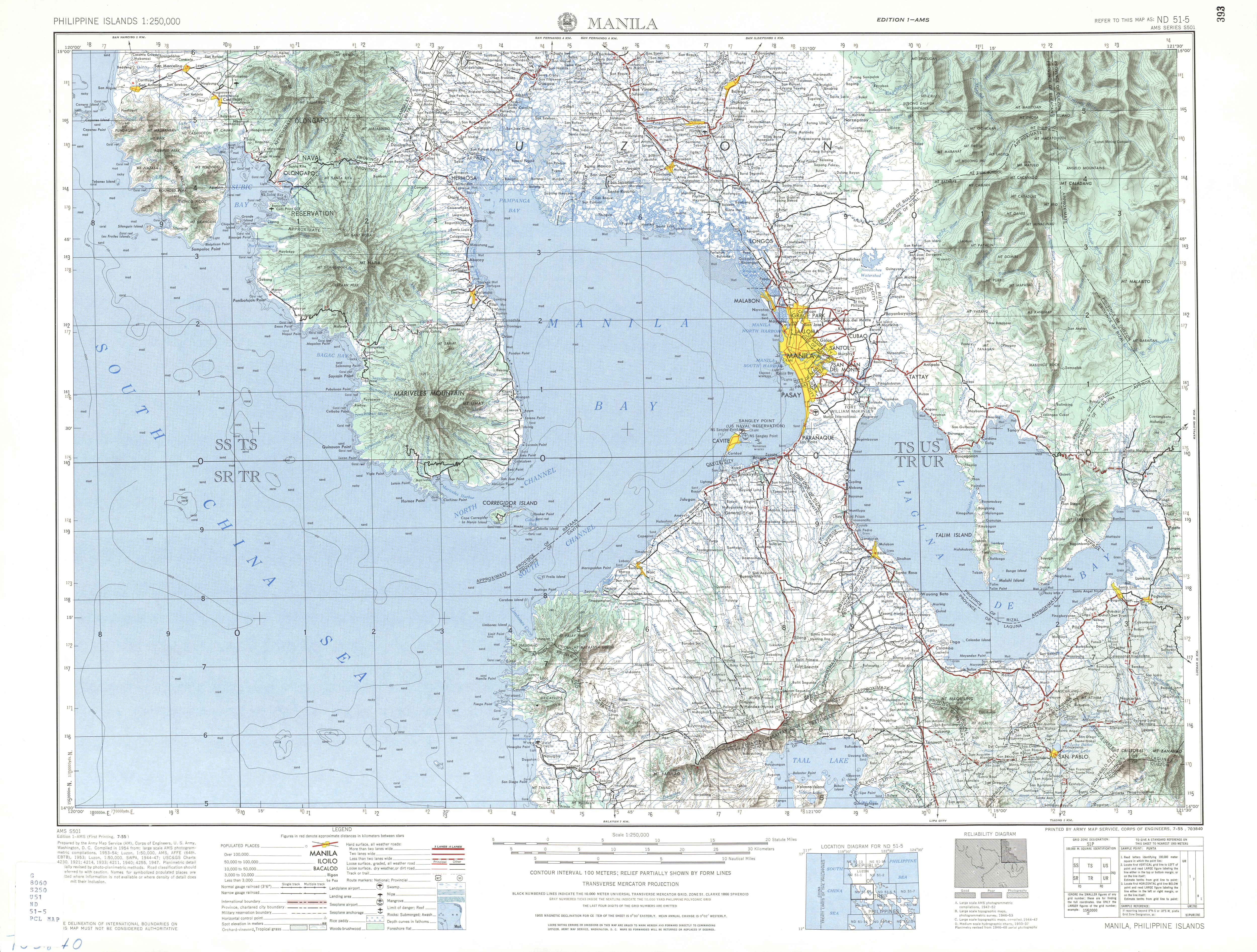
- U.S. Army corps of Engineers (1954). "Manila (topographical map)". University of Texas in Austin Library. Retrieved on 2014-08-03.
- "The Kentex Fire: A Conversation with Walden Bello". The Philippine STAR. Archived from the original on February 4, 2016. Retrieved January 27, 2016.
- Westfall, Matthew (September 6, 2012). Devil's Causeway: The True Story of America's First Prisoners of War in the Philippines, and the Heroic Expedition Sen. Rowman & Littlefield. ISBN 9780762787470 – via Google Books.
- Nepomuceno, Dolora N. (February 15, 2005). "The Laguna de Bay and Its Tributaries Water Quality Problems, Issues and Responses" (PDF). The Second General Meeting Of the Network of Asian River Basin Organizations. Indonesia: Network of Asian River Basin Organizations. Archived from the original (PDF) on December 7, 2006. Retrieved February 18, 2007.
- LLDA 1995, pp. 4–6.
- Department of Environment and Natural Resources, 1996
- Batu, M. (1996) Factors affecting productivity of selected inland bodies of water in the Philippines: The case of the Laguna Lake 1986 to 1996. Undergraduate thesis. San Beda College, Manila.
- Aquino; Tango; Canoy; Fontanilla; Basiao; Ong; and Quilang (2011). "DNA barcoding of fishes of Laguna de Bay, Philippines". Mitochondrial DNA. 22 (4): 143–153. doi:10.3109/19401736.2011.624613. PMID 22040082. S2CID 23016645.
{{cite journal}}: CS1 maint: uses authors parameter (link) - Santos-Borja, A., and D.N. Nepomuceno (2005). Laguna de Bay, Experiences and lessons learned brief Archived 2009-06-12 at the Wayback Machine, pp. in: 225–258 in: Lake Basin Management Initiative. Retrieved 13 November 2012
- Cuvin-Aralar, M.L.A. (2016). "Impacts of aquaculture on fish biodiversity in the freshwater lake Laguna de Bay, Philippines". Lakes & Reservoirs. 21 (1): 31–39. doi:10.1111/lre.12118.
- DENR, 1997
- Sly, 1984
- Solidarity for People’s Power (1992) Laguna de bay: Racing against time. Pamphlet article. Los Baños, Laguna, Philippines.
- Varca, Leonila M. (April 1, 2012). "Pesticide residues in surface waters of Pagsanjan-Lumban catchment of Laguna de Bay, Philippines". Agricultural Water Management. Assessing off-site migration of sediments and agrochemicals from agricultural/horticultural catchments in Philippines and Australia. 106: 35–41. doi:10.1016/j.agwat.2011.08.006. ISSN 0378-3774.
- "Group blames LLDA for Laguna Lake's deterioration". philstar.com. Archived from the original on June 2, 2016. Retrieved October 3, 2012.
- "Background on the Mega-Dike Issue". Leaders and Organizers of Community Organization in Asia. Archived from the original on August 5, 2002. Retrieved July 21, 2009.
- "Laguna de Bay Masterplan". Laguna Lake Development Authority. Archived from the original on January 29, 2009. Retrieved July 21, 2009.
- Alcazaren, Paulo (June 15, 2013). "City Sense: 10 reasons why it floods in Manila". The Philippine Star. STAR Group of Publications. Retrieved October 10, 2014.
- Melissa Alipalo (September 21, 2007). "Urban poor: small piped water networks help slums in Manila, Philippines". IRC. Archived from the original on October 26, 2009. Retrieved July 21, 2009.
- "VERA FILES FACT CHECK: Claim on Cory Aquino scrapping Marcos-era floodway NEEDS CONTEXT". VERA Files. December 9, 2020. Retrieved September 26, 2022.
- Japan International Cooperation Agency; CTI Engineering International Co. Ltd.; Nippon Koei Co. Ltd. (October 2020). Republic of The Philippines Follow-Up Study on Parañaque Spillway Project - Final Report (PDF) (Report). Vol. 1: Main Report. Department of Public Works and Highways, Republic of The Philippines. Retrieved October 11, 2022.
- Recueno, Aaron (August 9, 2022). "DPWH eyes Parañaque Spillway project to address Metro Manila flooding". Manila Bulletin. Retrieved September 26, 2022.
- "DPWH proposes Marikina Dam, Parañaque Spillway to control flooding". CNN Philippines. November 25, 2020. Retrieved September 26, 2022.
- "Private-Public Partnership Service – Laguna Lakeshore Expressway Dike". Archived from the original on November 13, 2013. Retrieved November 13, 2013.
- "PPP Center – Laguna Lakeshore Expressway Dike". Archived from the original on April 9, 2015. Retrieved April 4, 2015.
- Presidential Communications Development and Strategic Planning Office, Office of the President of the Philippines (June 20, 2014). "NEDA board approves biggest PPP project: Laguna Lakeshore Expressway-Dike". Official Gazette (Philippines). Manila: Government of the Republic of the Philippines.
- "8 companies interested in bidding for Laguna Lakeshore Expressway Dike Project". Archived from the original on August 12, 2014. Retrieved August 12, 2014.
- "DPWH-PPP Presentation" (PDF). Archived from the original (PDF) on November 13, 2013. Retrieved July 12, 2012.
- "Republic Act no. 4850"[permanent dead link]. Laguna Lake Development Authority. Retrieved on 2012-10-22.
- LLDA 2009, p. 9.
- Department of Environment and Natural Resources (1990). Administrative Order No. 35, March 20, 1990 'Revised Effluent Regulations of 1990, Revising and Amending the Effluent Regulations of 1982'. Archived July 19, 2011, at the Wayback Machine DENR Website. Retrieved on 2012-10-20.
- Department of Environment and Natural Resources (2005). "Implementing Rules and Regulations of the Clean Water Act of 2004 (Republic Act no. 9275)." Archived 2011-07-19 at the Wayback Machine DENR Website. Retrieved on 2012-10-20.
- "Why JICA is deploying sensors in Laguna Lake". abs-cbnnews. Retrieved April 21, 2015.
- Remi E. de Leon (2005). "Health Knowledge Processes and Flows in a Coastal Community in Victoria, Laguna Philippines; (Master's Thesis)". University of the Philippines Los Baños Graduate School.
{{cite journal}}: Cite journal requires|journal=(help) - Morales, Izah (September 22, 2008). "Being Filipino: Constructing a Modern-Day 'Bahay Kubo'". Philippine Daily Inquirer. Archived from the original on October 31, 2011. Retrieved April 26, 2008.
- Odal-Devora, Grace P. (2002). ""Bae" or "Bai": The Lady of the Lake". In Alejandro, Reyndaldo Gamboa (ed.). Laguna de Bay: The Living Lake. Unilever Philippines. ISBN 971-922-721-4.
Sources
- Laguna Lake Development Authority, LLDA (2009). "2009 Annual Report".
- Laguna Lake Development Authority, LLDA (1995). "Laguna de Bay Master Plan – Final Report".
Further reading
- Canonoy, F. V. (1997). Lake Laguna's environmental user fee system.
- Laguna Lake Development Authority. "Frequently Asked Questions (archived 2007-06-08)".
- McKitrick, R. (1999). A derivation of the marginal abatement cost curve. Archived June 6, 2011, at the Wayback Machine
- National Statistical Coordination Board (1996). Estimation of fish biomass in Laguna de Bay based on primary productivity.
External links
 Geographic data related to Laguna de Bay at OpenStreetMap
- Laguna Lake Development Authority
- Department of Environment and Natural Resources
"The Largest Lake in the Philippines" | |||||||
| Location |
|  | |||||
| Basin country |
| ||||||
| Islands | |||||||
| Primary outflow | |||||||
| Primary inflows |
| ||||||
| Settlements |
| ||||||
Luzon, Philippines | |||||||
| Major | |
|---|---|
| Minor |
|
| Artificial | |
Metro Manila | |||||
|---|---|---|---|---|---|
National Capital Region of the Philippines Manila (capital city) | |||||
| Administrative divisions |
| ||||
| Geography |
| ||||
| Government |
| ||||
| History |
| ||||
| Economy |
| ||||
| Public services and utilities |
| ||||
| Education |
| ||||
| Culture |
| ||||
| Transportation |
| ||||
| Other topics |
| ||||
| |||||
Authority control | |
|---|---|
| General |
|
| National libraries | |
| Other | |
На других языках
[de] Laguna de Bay
Der Laguna de Bay ist der größte See der Philippinen und der drittgrößte Süßwassersee im südostasiatischen Raum nach dem Tonle Sap in Kambodscha und dem Tobasee auf der Insel Sumatra, Indonesien. Er befindet sich auf der Insel Luzon zwischen den Provinzen Laguna im Süden und Rizal im Norden.- [en] Laguna de Bay
[es] Laguna de Bay
La laguna de Baý es el lago más grande de Filipinas, y el segundo lago de agua dulce tierra adentro en el sureste asiático, después del lago Toba, en Sumatra, Indonesia. Está localizado en la isla de Luzón, entre las provincias de La Laguna (al sur) y Rizal (al norte). La Gran Manila se encuentra en la costa oeste. Su superficie es de 949 km², y tiene una profundidad promedio de solo 2 m. El lago tiene una forma parecida a una W, con dos penínsulas saliendo de la costa norte. La parte central de la laguna es formada por una caldera volcánica sumergida. La Laguna de Baý drena hacia la bahía de Manila, a través del río Pasig. Este lago se llena de redes de los pescadores locales que regularmente pescan allí.[fr] Laguna de Bay
Laguna de Bay (en philippin : Lawa ng Bay) est un lac des Philippines, située au sud-est de Manille, sur l'île de Luçon. Il est également riverain des provinces de Rizal sur sa rive nord et Laguna sur sa rive sud.[ru] Бай (озеро)
Бай[1][2] (тагальск. Laguna de Bay) — крупнейшее озеро Филиппин. Находится на острове Лусон в провинциях Лагуна, Рисаль и Столичном регионе.Другой контент может иметь иную лицензию. Перед использованием материалов сайта WikiSort.org внимательно изучите правила лицензирования конкретных элементов наполнения сайта.
WikiSort.org - проект по пересортировке и дополнению контента Википедии