geo.wikisort.org - Reservoir
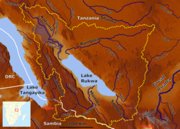
Lake Rukwa is an endorheic lake located the Rukwa Valley of Rukwa Region, Songwe Region and Katavi Region in southwestern Tanzania. The lake is the third largest inland body of water in the country.
| Lake Rukwa | |
|---|---|
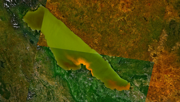 Lake Rukwa, as seen from space. | |
 Lake Rukwa | |
 | |
| Location | Rukwa Region, Songwe Region and Katavi Region, Tanzania. |
| Coordinates | 8°00′S 32°25′E |
| Type | alkaline |
| Catchment area | 88,000 km2 (34,000 sq mi)[1] |
| Basin countries | Tanzania |
| Surface elevation | 800 metres (2,600 ft) |
Geography
The alkaline Lake Rukwa lies midway between Lake Tanganyika and Lake Malawi at an elevation of about 800 metres (2,600 ft), in a parallel branch of the rift system. Almost half of the lake lies in Uwanda Game Reserve.[2]
Hydrology
The lake has seen large fluctuations in its size over the years, due to varying inflow of streams. Currently it is about 180 kilometres (110 mi) long and averages about 32 kilometres (20 mi) wide, making it about 5,760 square kilometres (2,220 sq mi) in size.[3] In 1929 it was only about 48 kilometres (30 mi) long, but in 1939 it was about 128 kilometres (80 mi) long and 40 kilometres (25 mi) wide.[4] During the early rifting of this part of Africa, the basin of Lake Rukwa may at times have been part of a much larger basin which also included the basins of Lake Tanganyika with Lake Malawi; ancient shorelines suggest a final date of overflow into Lake Tanganyika of 33,000BP.[5] For overflow to occur again, the lake's elevation would need to exceed 900 meters. Overflow into Lake Malawi is not possible now, since the pass between the two basin stands at over 2000 meters elevation.[6] (Neither Lake Tanganyika nor Lake Malawi can overflow into Lake Rukwa since they already overflow into the Atlantic and Indian Oceans respectively.)
There is an accumulation of selected heavy metals of Zinc, Mercury, Copper, Lead, Chromium and Nickel in sediment, water and muscle tissues of Clarias gariepinus (African catfish) and Oreochromis esculentus (Singida tilapia) fish was done in Lake Rukwa.[7]
Helium discovery
In 2016, an estimated 1.53 billion cubic meters (54.2 billion standard cubic feet) volume of helium gas was discovered in Lake Rukwa worth $3.5 billion.[8]
See also
References
- Lake Rukwa Bathymetry Survey Final Report 2014
- "Rukwa Uwanda Game Reserve". Utalii Travel and Safari. Retrieved 29 October 2010.
- Google Earth accessed 6 February 2007
- Encyclopædia Britannica Online/Lake Rukwa
- Lévêque, Christian (1997). Biodiversity Dynamics and Conservation: The Freshwater Fish of Tropical Africa. Cambridge University Press. p. 110.
- Google Maps
- Mapenzi, Levinus Leonard; Shimba, Moses Joel; Moto, Edward Angelo; Maghembe, Reuben Silas; Mmochi, Aviti John (January 2020). "Heavy metals bio-accumulation in tilapia and catfish species in Lake Rukwa ecosystem Tanzania". Journal of Geochemical Exploration. 208: 106413. doi:10.1016/j.gexplo.2019.106413. ISSN 0375-6742.
- "Helium 'could earn Tanzania $3.5bn'". www.thecitizen.co.tz. July 8, 2016.
This Tanzania location article is a stub. You can help Wikipedia by expanding it. |
На других языках
[de] Rukwasee
Der Rukwasee (früher auch Rikwasee, englisch Lake Rukwa) ist ein abflussloser Salzsee im südwestlichen Tansania. Die Gegend um den See ist nahezu unbewohnt, jedoch kommen viele Pendler hierher, um zu fischen.[1] Der See liegt teilweise im Gebiet des Uwanda Game Reserve.[2]- [en] Lake Rukwa
[fr] Lac Rukwa
Le lac Rukwa est un lac de soude (alcalin), endoréique situé dans le sud-ouest de la Tanzanie, à environ cent kilomètres à l'est du lac Tanganyika.[it] Lago Rukwa
Il lago Rukwa è un lago endoreico nella valle Rukwa situata nella parte sudoccidentale della Tanzania. Il lago è alcalino e si trova idealmente a metà del percorso tra il lago Tanganica e il lago Niassa, lungo la Rift Valley africana e probabilmente in contatto sotterraneo con questi due laghi. Il lago si trova a 800 m di altezza e è compreso per metà all'interno dell'area della Uwanda Game Reserve.[2][ru] Руква (озеро)
Руква — бессточное озеро, расположено на юго-западе Танзании между озёрами Танганьика и Ньяса. Это мелководное солёное озеро с площадью бассейна около 80 000 км² является частью экосистемы Руква вокруг национального парка Катави[1].Другой контент может иметь иную лицензию. Перед использованием материалов сайта WikiSort.org внимательно изучите правила лицензирования конкретных элементов наполнения сайта.
WikiSort.org - проект по пересортировке и дополнению контента Википедии