geo.wikisort.org - Island
Coron is the third-largest island in the Calamian Islands in northern Palawan in the Philippines. The island is part of the larger municipality of the same name. It is about 170 nautical miles (310 km) southwest of Manila and is known for several Japanese shipwrecks of World War II vintage. Because of its unique ecological features, the entire area is protected by several legal proclamations.[1]
 Coron Island Cove | |
 Coron Island Location within the Philippines | |
| Geography | |
|---|---|
| Coordinates | 11°55′45″N 120°14′30″E |
| Archipelago | Calamian Group of Islands |
| Adjacent bodies of water | Sulu Sea |
| Area | 71 km2 (27 sq mi) |
| Length | 20 km (12 mi) |
| Width | 9 km (5.6 mi) |
| Highest elevation | 600 m (2000 ft)[1] |
| Administration | |
Philippines | |
| Region | Mimaropa |
| Province | Palawan |
| Municipality | Coron |
| Demographics | |
| Population | 2649 (2010)[2] |
The island and surrounding fishing grounds are part of the ancestral domain of the indigenous Tagbanwa people, officially designated such on June 5, 1998.[1] Known as Calis among the Tagbanwas and Coronians, its tribal chieftain is Rodolfo Aguilar I.
The island comprises two barangays of the municipality of Coron: Banuang Daan and Cabugao.[1]
Geography
Partially between Busuanga and Culion islands, Coron Island faces the Sulu Sea and forms the eastern side of Coron Bay. It is about 20 kilometres (12 mi) long from north to south, and 9 kilometres (5.6 mi) at its widest point.
Part of the North Palawan Block, Coron Island is distinguished by its Late Triassic Coron Limestone.[3]
There are 11 lakes nestled in the rugged terrain, of which three have underground connections to the sea. There are a few mangroves in coastal areas.[1]
Diving
The area around the wrecks has rock formations which provide for snorkeling opportunities, with underwater visibility extending up to 80 feet (24 m). The water is often calm.
Coron is known for wreck diving Wreck dive sites are found in depths as shallow as 12 metres (39 ft) and as deep as 43 metres (141 ft). Wreck diving sites in Coron Bay include the Akitsushima, Irako, Kogyo Maru, Kyokuzan Maru, Okikawa Maru, Olympia Maru.[4]
Dive sites around Coron include many different reef dive sites and "Günter's Cave", also known as Cathedral Cave because during a certain time of the day, the sun throws a beam of light through a hole in the cave ceiling, illuminating the inside. It is possible to surface in the cave, as the hole in the cave-ceiling allows fresh air to enter. The cave is named after Günther Bernert, who was part of the first dive group to explore the cave, after hearing from local fishermen about its existence.[citation needed]
Other points of interest
Ecotourism has long surpassed diving as the top draw to Coron Island in the last decade. With domestic tourism on the rise due to a rapidly growing middle class, Coron is one of the top destinations for Filipinos to add to their wish list, with Coron Island containing some of the most iconic.
Gallery
![Kayangan Lake, dubbed the cleanest lake in Asia[8][9]](//upload.wikimedia.org/wikipedia/commons/thumb/3/34/Isola_di_coron%2C_lago_kayangan_02.jpg/288px-Isola_di_coron%2C_lago_kayangan_02.jpg)
 The Twin Lagoon in Coron Island
 Large rock formations at the Barracuda Lake
 Banol beach on Coron Island
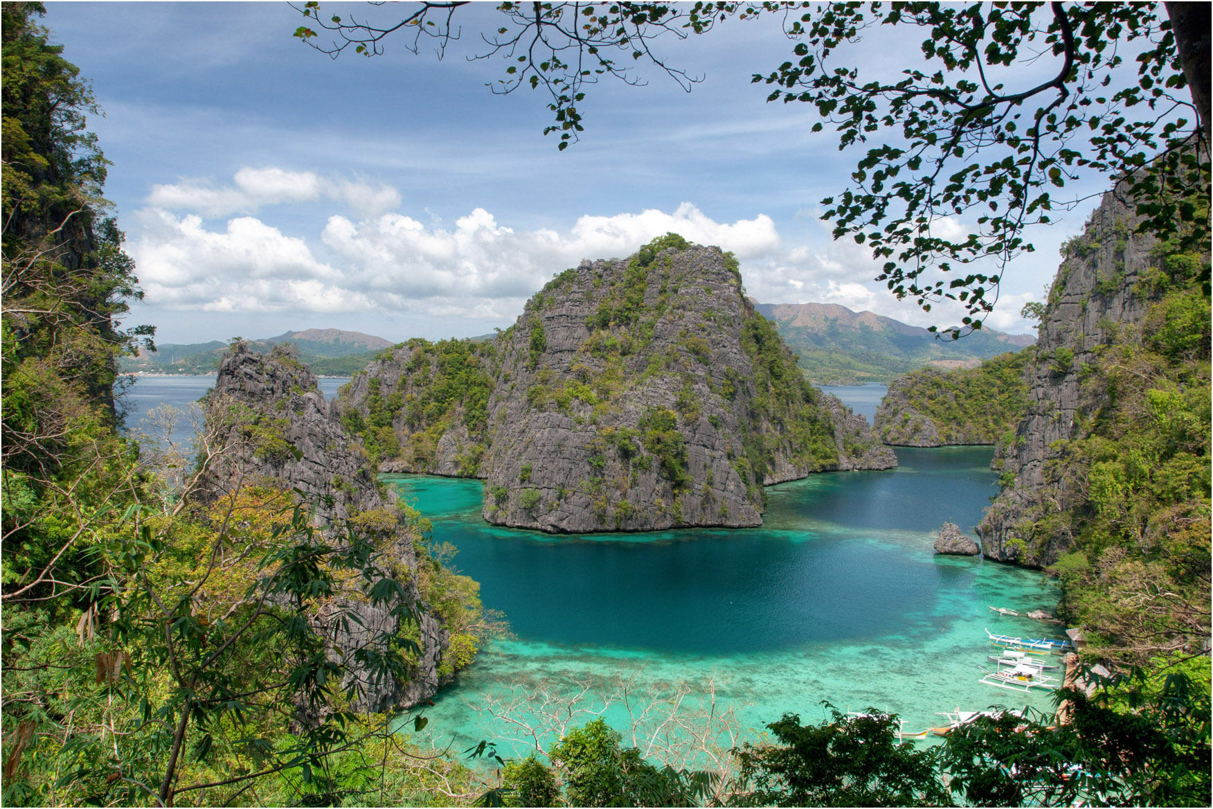
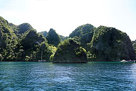 Coron Island rock formations
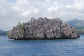 A stone islet in Coron Island
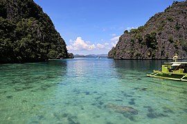 The bay near Kayangan Lake
 Waling-Waling Island
![Kayangan Lake, dubbed the cleanest lake in Asia[8][9]](http://upload.wikimedia.org/wikipedia/commons/3/34/Isola_di_coron%2C_lago_kayangan_02.jpg)


See also
References
- "Coron Island Natural Biotic Area". World Heritage Centre: Tentative lists. UNESCO. Retrieved 16 February 2016.
- "Total Population by Province, City, Municipality and Barangay: as of May 1, 2010" (PDF). 2010 Census of Population and Housing. National Statistics Office. Archived from the original (PDF) on 15 November 2012. Retrieved 16 February 2016.
- Zamoras, Lawrence; Matsuoka, Atsushi (January 2001). "The Malampaya Sound Group in the Calamian Islands, North Palawan Block (Philippines)". ResearchGate GmbH. Retrieved 2 June 2022.
- "Wrecks of Coron Bay". Dive Magazine. 16 November 2021. Retrieved 2 June 2022.
- "Get the important info on Kayangan Lake before you go". Unofficialguide.ph. Retrieved 20 September 2018.
- "Photo Story: Barracuda Lake". Unofficialguide.ph. Retrieved 25 September 2018.
- "Photo Story: Coron's Amazing Twin Lagoons". Unofficialguide.ph. Retrieved 23 September 2018.
- Ferdz (11 July 2008). "Coron: Scenic Kayangan Lake". Retrieved 20 April 2017.
- "Kayangan Lake (Coron, Philippines): Top Tips Before You Go - TripAdvisor". Retrieved 20 April 2017.
External links
![]() Media related to Coron Island at Wikimedia Commons
Media related to Coron Island at Wikimedia Commons
![]() Coron travel guide from Wikivoyage
Coron travel guide from Wikivoyage
World Heritage Sites in the Philippines | ||
|---|---|---|
| Cultural |
| |
| Natural |
| |
The 40 largest islands of the Philippines | ||
|---|---|---|
| ||
| ||
На других языках
[de] Coron (Insel)
Coron ist die drittgrößte der Calamian-Inseln, die wiederum zu den Palawan-Inseln im Westen der Philippinen gehört.- [en] Coron Island
[fr] Coron (île)
Coron est la troisième plus grande île des Calamian dans le nord de la province de Palawan aux Philippines.[it] Coron (isola)
Coron è una delle isole dell'arcipelago delle Calamian nel Mar Cinese Meridionale che appartiene alle Filippine. È la più piccola delle principali isole delle Calamian con una superficie di 71 km² ed una popolazione di circa 2.500 abitanti (2007).[ru] Корон (остров)
Корон (исп. Isla de Corón) — остров, расположенный в море Сулу. Административно относится к муниципалитету Корон[en] (север провинции Палаван, регион МИМАРОПА, Филиппины).Другой контент может иметь иную лицензию. Перед использованием материалов сайта WikiSort.org внимательно изучите правила лицензирования конкретных элементов наполнения сайта.
WikiSort.org - проект по пересортировке и дополнению контента Википедии