geo.wikisort.org - Island
Dinagat Island is an island located northeast of Mindanao in the Philippines.
 Location within the Philippines | |
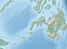 Dinagat Island Location within Mindanao  Dinagat Island Dinagat Island (Philippines) | |
| Geography | |
|---|---|
| Coordinates | 10°9′46″N 125°35′22″E |
| Archipelago | Dinagat Islands |
| Adjacent bodies of water |
|
| Area | 802.12 km2 (309.70 sq mi) |
| Administration | |
Philippines | |
| Region | Caraga |
| Province | Dinagat Islands |
| Municipalities | |
| Demographics | |
| Population | 106,951 (2000) |
| Pop. density | 133.3/km2 (345.2/sq mi) |
| Ethnic groups | Visayans (Surigaonon) |
Until December 2006, it was part of the province of Surigao del Norte. Being its main island, almost all municipalities of the province of Dinagat Islands are located on it.

External links
 Geographic data related to Dinagat Island at OpenStreetMap
The 40 largest islands of the Philippines | ||
|---|---|---|
| ||
| ||
This article about a location in Caraga region is a stub. You can help Wikipedia by expanding it. |
На других языках
[de] Dinagat (Insel)
Dinagat ist eine Insel im Osten der Philippinen, die zur philippinischen Provinz Dinagat Islands gehört und in der Philippinensee liegt.- [en] Dinagat Island
[es] Isla de Dinágat
Dinágat es una isla situada en Filipinas, adyacente a la de Mindanao. Corresponde a la provincia de Islas de Dinagat situada en la Región Administrativa de Caraga, también denominada Región XIII.Текст в блоке "Читать" взят с сайта "Википедия" и доступен по лицензии Creative Commons Attribution-ShareAlike; в отдельных случаях могут действовать дополнительные условия.
Другой контент может иметь иную лицензию. Перед использованием материалов сайта WikiSort.org внимательно изучите правила лицензирования конкретных элементов наполнения сайта.
Другой контент может иметь иную лицензию. Перед использованием материалов сайта WikiSort.org внимательно изучите правила лицензирования конкретных элементов наполнения сайта.
2019-2026
WikiSort.org - проект по пересортировке и дополнению контента Википедии
WikiSort.org - проект по пересортировке и дополнению контента Википедии