geo.wikisort.org - Reservoir
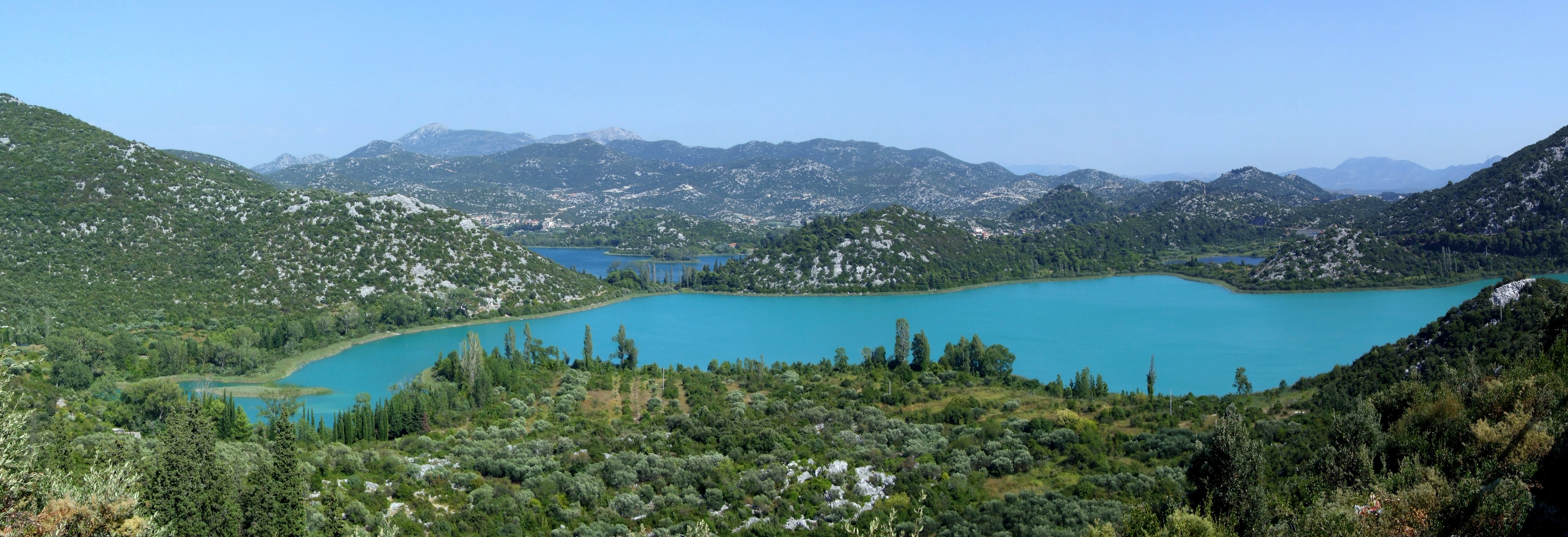
The Baćina lakes (Croatian: Baćinska jezera) are located in Dalmatia, Croatia. The lakes are named after the inland town of Baćina close to the port city of Ploče.[1] The lakes are part of a picturesque landscape and surrounded by mountains. They are situated between Makarska and Dubrovnik. It is a crypto-depression lake, with its bottom below the surface of the sea.
Description

Despite its proximity to the sea and the permeable nature of the karst area,[2] they are fresh water lakes. The seven lakes cover an area of 138 hectares and they are named Oćuša, Crniševo, Podgora, Sladinac, Vrbnik, Šipak and Plitko. Six of these lakes are linked. The only isolated lake is Vrbnik.The largest lake is Oćuša and the deepest is the Crniševo (34 m). The lakes are connected with the sea and at times the water can be brackish,[3] also the surface of the lakes lies 80 cm above sea level. Salty water is found at the bottom of the deepest lake Crnisevo.
Lake Vrgorac (Croatian: Vrgorsko jezero) located to the north of the Baćina lakes drains into the Adriatic Sea through them.
At the turn of the century the Austro-Hungarian[4] government built a tunnel to the sea. This led to the lowering of the lake level which has brought about biological changes. The tunnel currently runs underneath the Adriatic Highway.
In recent times the lake has become a well-known hunting ground for grey mullet (Mugil saliens).
See also
 Lakes portal
References
- Dalmatia.Net Archived March 13, 2011, at the Wayback Machine Bacina Lakes
- CSA Illumina Archived March 7, 2012, at the Wayback Machine
- Bacina Lakes Klek.info
- Lakes in the Croatian Limestone Region Archived March 7, 2012, at the Wayback Machine by Milivoj Petrik. The present hydrologic regime of the Batina lakes differs from the past one because, in 1912, a tunnel was constructed from the basin Sladinac in to the port of Plote in order to lower the level of the lakes. page 16.
External links
Hydrography of Croatia | ||||||
|---|---|---|---|---|---|---|
| Rivers |
|  | ||||
| Lakes | ||||||
| Valleys, estuaries, canyons, wetlands |
| |||||
| Waterfalls | ||||||
| Canals |
| |||||
| Adriatic Sea |
| |||||
| Authority control |
|
|---|
На других языках
[de] Baćina-Seen
Die Baćina-Seen (kroatisch Baćinska jezera) befinden sich im Süden Kroatiens. Dort bilden mehrere Seen bei der Ortschaft Baćina nahe der Stadt Ploče auf der rechten Seite der Deltamündung der Neretva in der Gespanschaft Dubrovnik-Neretva eine Seenlandschaft.- [en] Baćina lakes
[ru] Бачинские озёра
Бачинские озёра (хорв. Baćinska jezera) — озёрная система в Хорватии близ побережья Адриатического моря. Расположены в нескольких километрах к северу от портового города Плоче. Имеют крипто-депрессионное происхождение, глубочайшая точка Бачинских озёр находится в 27 метрах ниже уровня моря. Благодаря живописным пейзажам на берегах привлекают большое число туристов. Территория озёр принадлежит жупании Дубровник-Неретва.Другой контент может иметь иную лицензию. Перед использованием материалов сайта WikiSort.org внимательно изучите правила лицензирования конкретных элементов наполнения сайта.
WikiSort.org - проект по пересортировке и дополнению контента Википедии