geo.wikisort.org - Mountains
Sgurr a' Choire Ghlais is a mountain in the North-west Highlands of Scotland. It lies between Glen Strathfarrar and Glen Orrin and it is an excellent viewpoint, being the highest mountain in its group - a group which includes the Munros of Sgurr na Ruaidhe, Sgurr Fhuar-thuill and Carn nan Gobhar. Northwards there is no higher ground apart from the Fannaichs.
 | This article needs additional citations for verification. (September 2014) |
| Sgurr a' Choire Ghlais | |
|---|---|
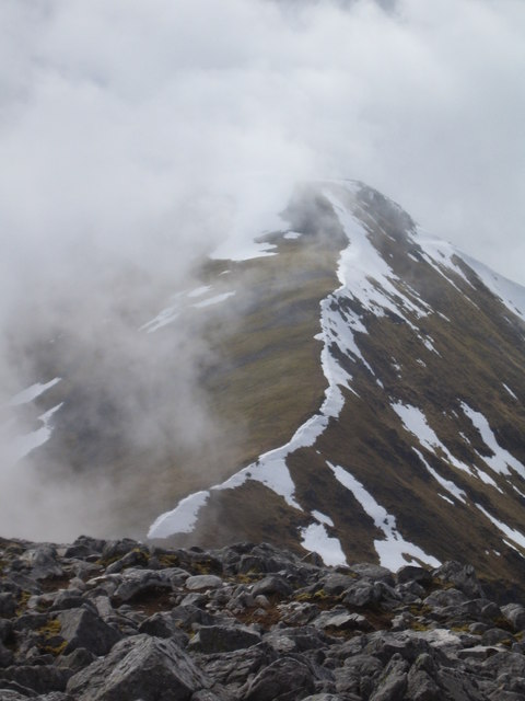 The north-east ridge | |
| Highest point | |
| Elevation | 1,083 m (3,553 ft)[1] |
| Prominence | 818 m (2,684 ft)Ranked 31st in British Isles |
| Parent peak | Sgurr na Lapaich |
| Listing | Munro, Marilyn |
| Naming | |
| English translation | Rocky Peak of the Grey Corrie |
| Language of name | Gaelic |
| Pronunciation | Scottish Gaelic: [ˈs̪kuːrˠ ə ˈxɔɾʲə ˈɣl̪ˠaʃ] English approximation: SKOOR-ə-COR-yə-GLASH |
| Geography | |
| Location | Glen Strathfarrar, Scotland |
| OS grid | NH259430 |
| Topo map | OS Landranger 25 |
It is one of the most difficult hills to reach in Scotland, the shortest route involving a 10-mile approach up Glen Strathfarrar. A bicycle, or permission to drive along the private road up Strathfarrar, may shorten the approach.
See also
 |
Wikimedia Commons has media related to Sgùrr a' Choire Ghlais. |
- List of mountains of the British Isles by relative height
- List of Munros
- List of Marilyns in the Northern Highlands
Footnotes
- "walkhighlands Sgurr a'Choire Ghlais". walkhighlands.co.uk. 2014. Retrieved 9 January 2014.
Most prominent mountains of Britain and Ireland (the P600s) | ||
|---|---|---|
| Northern Highlands (20) |    | |
| Western Highlands (20) | ||
| Central and Eastern Highlands (13) | ||
| Southern Highlands (15) |
| |
| Islands (13) | ||
| Scottish Lowlands, England and Wales (13) | ||
| Republic of Ireland, Northern Ireland (25) | ||
Munros of Scotland: Kyle of Lochalsh to Inverness | |||
|---|---|---|---|
 |  | ||
List of Munros | |||
 | This Highland location article is a stub. You can help Wikipedia by expanding it. |
На других языках
[de] Sgùrr a’ Choire Ghlais
Der Sgùrr a’ Choire Ghlais ist ein 1.083 m (3.553 ft) hoher Berg in den schottischen Highlands. Er ist als Munro und Marilyn eingestuft. Sein gälischer Name kann in etwa mit Felsige Spitze des grauen Kars übersetzt werden.[1] Er liegt in einer weitgehend unbesiedelten Berglandschaft der Northwest Highlands im Strathfarrar Forest, etwa 40 Kilometer westlich von Inverness.- [en] Sgùrr a' Choire Ghlais
Текст в блоке "Читать" взят с сайта "Википедия" и доступен по лицензии Creative Commons Attribution-ShareAlike; в отдельных случаях могут действовать дополнительные условия.
Другой контент может иметь иную лицензию. Перед использованием материалов сайта WikiSort.org внимательно изучите правила лицензирования конкретных элементов наполнения сайта.
Другой контент может иметь иную лицензию. Перед использованием материалов сайта WikiSort.org внимательно изучите правила лицензирования конкретных элементов наполнения сайта.
2019-2026
WikiSort.org - проект по пересортировке и дополнению контента Википедии
WikiSort.org - проект по пересортировке и дополнению контента Википедии