geo.wikisort.org - Mountains
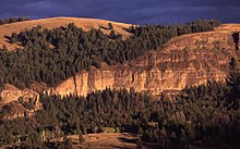
Mount Norris, elevation 9,842 feet (3,000 m), is a mountain peak in the northeast section of Yellowstone National Park in the Absaroka Range of the U.S. state of Wyoming. In 1875, the peak was named for and by Philetus Norris, the park's second superintendent from 1877 to 1882. While on a visit to the park, Norris and several mountain guides, including Collins Jack "Yellowstone Jack" Baronette, ascended the peak at the head of the Lamar Valley and presumed they were the first white men to do so, thus naming it Mount Norris.[2]

| Mount Norris | |
|---|---|
 January 2010 | |
| Highest point | |
| Elevation | 9,842 ft (3,000 m)[1] |
| Coordinates | 44°52′28″N 110°05′41″W[1] |
| Geography | |
 Mount Norris Yellowstone National Park, Park County, Wyoming | |
| Topo map | Wahb Springs |
See also
- Mountains and mountain ranges of Yellowstone National Park
Notes
- "Mount Norris". Geographic Names Information System. United States Geological Survey.
- Whittlesey, Lee (1988). Yellowstone Place Names. Helena, MT: Montana Historical Society Press. p. 106. ISBN 0-917298-15-2.
На других языках
[de] Mount Norris (Wyoming)
Der Mount Norris ist ein Berg im nordöstlichen Teil des Yellowstone-Nationalparks im US-Bundesstaat Wyoming. Sein Gipfel hat eine Höhe von 3028 m und erhebt sich über das Lamar Valley. Er befindet sich wenige Kilometer südlich der Grenze zum Bundesstaat Montana und ist Teil der Absaroka-Bergkette in den Rocky Mountains.[1][2]- [en] Mount Norris
Текст в блоке "Читать" взят с сайта "Википедия" и доступен по лицензии Creative Commons Attribution-ShareAlike; в отдельных случаях могут действовать дополнительные условия.
Другой контент может иметь иную лицензию. Перед использованием материалов сайта WikiSort.org внимательно изучите правила лицензирования конкретных элементов наполнения сайта.
Другой контент может иметь иную лицензию. Перед использованием материалов сайта WikiSort.org внимательно изучите правила лицензирования конкретных элементов наполнения сайта.
2019-2025
WikiSort.org - проект по пересортировке и дополнению контента Википедии
WikiSort.org - проект по пересортировке и дополнению контента Википедии


