 Mount Holmes' namesake, William H. Holmes
 Mount Holmes as seen from Winter Creek, 1890
 Mount Holmes and other peaks, 1963
 Looking east from summit of Mount Holmes, 1965
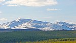 2009
2009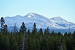 Mount Holmes (center) from Madison River, October 2010
geo.wikisort.org - Mountains
Mount Holmes is a prominent mountain peak in Yellowstone National Park. It is the tallest mountain in the Wyoming portion of the Gallatin Range. Mount Holmes is located in the northwestern part of the park and marks the southern terminus of the Gallatin Range. It is the source of Indian Creek, a tributary of the Gardner River.
| Mount Holmes | |
|---|---|
 Morning light on Trilobite Point and Mt. Holmes | |
| Highest point | |
| Elevation | 10,336 ft (3,150 m) NAVD 88[1] |
| Coordinates | 44°49′08″N 110°51′21″W[2] |
| Geography | |
| Location | Yellowstone National Park, Park County, Wyoming, U.S. |
| Parent range | Gallatin Range |
| Topo map | Mount Holmes |
| Climbing | |
| Easiest route | Hike |
There was a historic fire watch tower near the top of Mount Holmes, before it was burned due to a lightning strike.[3] The Bannock Trail crosses the mountains close to Mount Holmes.
History
An 1860 map by Captain William F. Raynolds showed this peak as Mount Gallatin. Prior to 1878, the peak was routinely referred to as Mount Madison because of its proximity to the Madison River. In 1878 Henry Gannett and geologist William H. Holmes, members of the third Hayden Geologic Survey, ascended the peak. Gannett named the peak Mount Holmes.[4]
The summit of Mount Holmes can be reached via the 10.8 miles (17.4 km) Mount Holmes-Winter Creek trail. The trailhead is located near Apollonaris Spring on the Mammoth-Norris section of the Grand Loop Road.[5]
Images of Mount Holmes


See also
- Mountains and mountain ranges of Yellowstone National Park
- Mount Holmes (Utah)
Notes
- "Mount Holmes, Wyoming". Peakbagger.com. Retrieved 2013-01-19.
- "Mount Holmes". Geographic Names Information System. United States Geological Survey.
- "Historic Mount Holmes Fire Lookout in Yellowstone Park burns down after lightning strike". KTVQ.com. 2019-07-17. Retrieved 2019-07-18.
- Whittlesey, Lee (1988). Yellowstone Place Names. Helena, MT: Montana Historical Society Press. p. 105. ISBN 0-917298-15-2.
- Schneider, Bill (2003). Hiking Yellowstone National Park. Guilford, CT: Falcon Press. pp. 129–131. ISBN 0-7627-2539-7.
Yellowstone National Park - Norris and Madison | ||
|---|---|---|
Geothermal features, historic structures and other attractions in the Norris and Madison Junction areas | ||
| Norris Geyser Basin |
|  |
| Gibbon Geyser Basin |
| |
| Structures and History |
| |
| Geography and Geology |
| |
| ||
Cheyenne (capital) | ||
| Topics |
|  Seal of Wyoming |
| Society |
| |
| Regions |
| |
| Cities |
| |
| Counties | ||
На других языках
[de] Mount Holmes (Wyoming)
Der Mount Holmes ist ein Berg im nordwestlichen Teil des Yellowstone-Nationalparks im US-Bundesstaat Wyoming. Sein Gipfel hat eine Höhe von 3149 m und ist der dritthöchste Gipfel der Gallatin Range in den Rocky Mountains. Höher sind nur der Electric Peak und der Joseph Peak einige Kilometer weiter nördlich. Er befindet sich einige Kilometer östlich der Grenze zum Bundesstaat Montana und bildet das südliche Ende der Gallatin-Range. Der Indian Creek, ein Nebenfluss des Gardner River, entspringt am Mount Holmes.[1][2] Der Gipfel wird normalerweise über den Mount Holmes Trail bestiegen.- [en] Mount Holmes
[ru] Холмс (гора)
Холмс (англ. Mount Holmes) — гора, расположенная в северо-западной части Йеллоустонского национального парка в округе Парк (штат Вайоминг, США)[2]. Имея высоту 3150 м, является 31-й по высоте горой штата[en].Текст в блоке "Читать" взят с сайта "Википедия" и доступен по лицензии Creative Commons Attribution-ShareAlike; в отдельных случаях могут действовать дополнительные условия.
Другой контент может иметь иную лицензию. Перед использованием материалов сайта WikiSort.org внимательно изучите правила лицензирования конкретных элементов наполнения сайта.
Другой контент может иметь иную лицензию. Перед использованием материалов сайта WikiSort.org внимательно изучите правила лицензирования конкретных элементов наполнения сайта.
2019-2026
WikiSort.org - проект по пересортировке и дополнению контента Википедии
WikiSort.org - проект по пересортировке и дополнению контента Википедии