geo.wikisort.org - Mountains
Amphitheater Mountain is a prominent 11,042-foot-elevation (3,366 meter) mountain summit located in Park County, Wyoming, United States.[2]
| Amphitheater Mountain | |
|---|---|
 Southwest aspect | |
| Highest point | |
| Elevation | 11,042 ft (3,366 m)[1] |
| Prominence | 1,422 ft (433 m)[1] |
| Parent peak | Pilot Peak (11,522 ft)[1] |
| Isolation | 5.60 mi (9.01 km)[1] |
| Coordinates | 44°58′25″N 109°59′55″W[2] |
| Geography | |
 Amphitheater Mountain Location in Wyoming  Amphitheater Mountain Amphitheater Mountain (the United States) | |
| Location | Yellowstone National Park Park County, Wyoming, U.S. |
| Parent range | Absaroka Range Rocky Mountains |
| Topo map | USGS Pilot Peak |
| Geology | |
| Type of rock | volcanic |
Description
The peak is situated southwest of the town of Cooke City, Montana, at the northeast corner of Yellowstone National Park, two miles south of the park's Northeast Entrance Station. It is part of the Absaroka Range, and a portion of the mountain is within the North Absaroka Wilderness. Topographic relief is significant as the north aspect rises over 3,600 feet (1,097 meters) above Silver Gate in two miles. Volcanoes of the early Eocene supplied the material that formed the mountain 50–55 million years ago, and here created some of the most rugged terrain in Yellowstone Park.[3] The mountain's name has been officially adopted by the United States Board on Geographic Names.[2]
Climate
According to the Köppen climate classification system, Amphitheater Mountain is located in a subarctic climate zone with long, cold, snowy winters, and cool to warm summers.[4] Temperatures can drop below −10 °F with wind chill factors below −30 °F. Precipitation runoff from the mountain drains into tributaries of the Lamar River.
Gallery
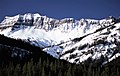 Amphitheater Mountain with snow from Silver Gate, Montana
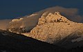 North aspect
 From the southwest with summit left of center
 from north
 subsidiary peaks on the south ridge
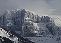 west ridge
 Soda Butte and Amphitheater Mountain at sunset


See also
References
- "Amphitheater Mountain - 11,042' WY". listsofjohn.com. Retrieved 2021-08-11.
- "Amphitheater Mountain". Geographic Names Information System. United States Geological Survey. Retrieved 2021-08-11.
- Mary Meagher, Douglas B. Houston, Yellowstone and the Biology of Time, 1999, University of Oklahoma Press, ISBN 9780806130064, page 142.
- Peel, M. C.; Finlayson, B. L.; McMahon, T. A. (2007). "Updated world map of the Köppen−Geiger climate classification". Hydrol. Earth Syst. Sci. 11. ISSN 1027-5606.
External links
- Weather forecast: Amphitheater Mountain
На других языках
[de] Amphitheater Mountain (Wyoming)
Der Amphitheater Mountain ist ein Berg im nordöstlichen Teil des Yellowstone-Nationalparks im US-Bundesstaat Wyoming. Sein Gipfel hat eine Höhe von 3366 m. Er ist Teil der Absaroka-Bergkette in den Rocky Mountains und liegt wenige Kilometer südwestlich des Ortes Cooke City.[1] Er befindet sich 3 km südlich der Grenze zum Bundesstaat Montana; der Abiathar Peak liegt rund 2 km westlich- [en] Amphitheater Mountain (Wyoming)
[fr] Amphitheater Mountain
Amphitheater Mountain est un sommet du comté de Park, au Wyoming, dans l'Ouest des États-Unis. Il culmine à 3 366 mètres d'altitude dans la chaîne Absaroka. Il se trouve à la bordure du parc national de Yellowstone et de la forêt nationale de Shoshone.Другой контент может иметь иную лицензию. Перед использованием материалов сайта WikiSort.org внимательно изучите правила лицензирования конкретных элементов наполнения сайта.
WikiSort.org - проект по пересортировке и дополнению контента Википедии