geo.wikisort.org - Island
Tatakoto is an atoll in the Tuamotu group in French Polynesia.
Tatakoto | |
|---|---|
Commune | |
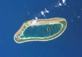 NASA picture of Tatakoto Atoll | |
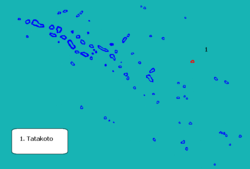 | |
Location of Tatakoto  | |
| Coordinates: 17°21′06″S 138°24′05″W | |
| Country | France |
| Overseas collectivity | French Polynesia |
| Subdivision | Îles Tuamotu-Gambier |
| Area 1 | 7.3 km2 (2.8 sq mi) |
| Population (2017) | 259 |
| • Density | 35/km2 (92/sq mi) |
| Time zone | UTC−10:00 |
| INSEE/Postal code | 98751 /98783 |
| 1 French Land Register data, which excludes lakes, ponds, glaciers > 1 km2 (0.386 sq mi or 247 acres) and river estuaries. | |
Tatakoto is one of the more isolated atolls of the Tuamotus. It is situated in the east of the archipelago, 1,182 kilometres (734 miles) from Tahiti. This atoll is 14 kilometres (9 miles) long and 3.5 kilometres (2 miles) wide. It has one large island and 65 islets separated by numerous channels on the reef surrounding the lagoon. The islands are mostly located on its windward side (south). All the islands are flat, not much higher than the ocean level. Its land area is about 7.3 km2, and the lagoon area is about 20 km2.
The main settlement is Tumukuru, and the total population was 259 in the 2017 census.[1]
History
Tatakoto Atoll was sighted the same day by two Spaniards. In the second expedition of the Águila, the two captains, Domingo de Bonechea and José Andía y Varela, separated when leaving Peru and did not see each other until reaching Tahiti. On 29 October 1774 (the day of Saint Narcissus) the two disembarked on Tatakoto without meeting. They named the island "San Narciso".[2] Historically the island was also known as "d'Augier".
Chronicler José Andía described the atoll as "extremely agreeable to the eyes by being very populated by shrubs." At the beginning of the twentieth century France established a colony and replanted the island with coconut palms, which still cover the island.
Tatakoto Airport was inaugurated in 1979.
Administration
Administratively Tatakoto Atoll has its own commune, which belongs to the Îles Tuamotu-Gambier administrative subdivision of French Polynesia.[3]
Transport
The atoll is served by the Tatakoto Airport (IATA: TKV, ICAO: NTGO).
References
- Répartition de la population en Polynésie française en 2017, Institut de la statistique de la Polynésie française
- Corney, Bolton Granvill The quest and occupation of Tahiti by emissaries of Spain during the years 1772-1776, London, 1913, Vol I, p.XLIII, XLVII
- Décret n° 2005-1611 du 20 décembre 2005 pris pour l'application du statut d'autonomie de la Polynésie française, Légifrance
External links
Tuamotu Archipelago and Gambier Islands of French Polynesia | |||
|---|---|---|---|
Tuamotus Gambiers | Islands/Atolls | ||
| Island groups | |||
На других языках
[de] Tatakoto
Tatakoto (auch Takoto, alter Name: Clerke Island) ist ein Atoll im Tuamotu-Archipel in Französisch-Polynesien. Es liegt vergleichsweise isoliert im östlichen Teil des Archipels, 1.182 km nordöstlich von Tahiti und 170 km nordwestlich von Pukarua.- [en] Tatakoto
[es] Tatakoto (atolón)
Tatakoto es un atolón de las Tuamotu, en la Polinesia Francesa. Está situado al este del archipiélago, a 1.182 km de Tahití.[fr] Tatakoto
Tatakoto est un atoll situé dans l'archipel des Tuamotu en Polynésie française. Celui-ci est le chef-lieu de la commune de Tatakoto.[it] Tatakoto
Tatakoto è un atollo appartenente all'arcipelago delle Isole Tuamotu nella Polinesia francese. È situato 1.182 km a est di Tahiti.[ru] Татакото
Татакото (фр. Tatakoto) — один из самых отдалённых атоллов архипелага Туамоту (Французская Полинезия).Другой контент может иметь иную лицензию. Перед использованием материалов сайта WikiSort.org внимательно изучите правила лицензирования конкретных элементов наполнения сайта.
WikiSort.org - проект по пересортировке и дополнению контента Википедии