geo.wikisort.org - Island
Tuanake or Mata-rua-puna[2] is a small atoll located in the Tuamotu Archipelago in French Polynesia. He made up the Raevski Islands subgroup with Tepoto Sud and Hiti. It is administratively attached to the municipality of Makemo.
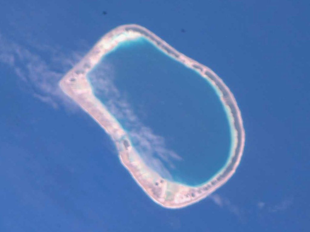 NASA picture of Tuanake Atoll | |
 Tuanake | |
| Geography | |
|---|---|
| Location | Pacific Ocean |
| Coordinates | 16°40′S 144°13′W |
| Archipelago | Tuamotus |
| Area | 26 km2 (10 sq mi) (lagoon) 6 km2 (2 sq mi) (above water) |
| Length | 9.5 km (5.9 mi) |
| Width | 6.5 km (4.04 mi) |
| Administration | |
France | |
| Overseas collectivity | French Polynesia |
| Administrative subdivision | Tuamotus |
| Commune | Makemo |
| Demographics | |
| Population | 6[1] (2017) |
Geography
Tuanake is located 7.5 kilometres (4.7 miles) west of Hiti, the nearest island, and 545 km east of Tahiti. It is a small semi-circular atoll 9.5 kilometres (5.9 miles) in length and 6.5 kilometres (4.0 miles) in maximum width for an emerged area of 6 square kilometres (2.3 square miles). Its 26 square kilometres (10 square miles) lagoon is accessible by a very shallow pass located to the south.
Tuanake has long been permanently uninhabited, but the 2017 census counts six inhabitants.[1]
History
The first recorded European to sight Tuanake was Russian explorer Fabian Gottlieb von Bellingshausen on July 15, 1820, who named it “Raevski Island”.[3][4] During his expedition, the American navigator Charles Wilkes approached him on December 20, 1840, notified the name of "Tunaki" and named him Reid Island.[3]
In the nineteenth century, Tuanake became a French territory then populated by a few indigenous inhabitants who obey the chief of Katiu just like the Tepoto Sud and Hiti atolls.[5]
Administration
Tuanake belongs to the commune of Makemo, which consists of the atolls of Makemo, Haraiki, Marutea Nord, Katiu, Tuanake, Hiti, Tepoto Sud, Raroia, Takume, Taenga and Nihiru. Tuanake Atoll is permanently uninhabited.
Economy
Traditional fishing is practiced with the use of two fish parks located on hoas in the south of the atoll.[6] In recent years, Tuanake has been exploited by the inhabitants of Katiu for sea cucumber fishing for export to Asia.[7]
Flora and fauna
The presence of individuals of the species Acrocephalus atyphus and Gallicolumba erythroptera—an extremely threatened species with only about one hundred individuals recorded in the Pacific—has been reported in Tuanake as well as an endemic population of Tuamotu sandpipers.[8]
References
- "Répartition de la population de la Polynésie française par île en 2017" (in French). Institut de la statistique de la Polynésie française (ISPF). Retrieved 2019-02-27.
- (in English) J.L. Young (December 1899). "Names of the Paumotu Islands, with the Old Names So Far As They Are Known". The Journal of the Polynesian Society. 8 (4): 264–8.
- Bonvallot, Jacques (1994). Les Atolls des Tuamotu. IRD editions. pp. 275–282. ISBN 9782709911757. Retrieved 14 September 2021.
- Toullelan, Pierre-Yves (1 January 1991). Tahiti et ses archipels (in French). KARTHALA Editions. p. 61. ISBN 978-2-86537-291-1.
- Avalle, Étienne (1866). Notices sur les colonies françaises: accompagnées d'un atlas de 14 cartes (in French). Paris: Challamel aîné. p. 638.
- Atlas de Polynésie (in French). Department of Marine Resources of the Government of French Polynesia. Archived from the original on 14 September 2021. Retrieved 11 April 2019.
- "Ouverture de la pêche aux holothuries (rori) en 2019". Direction des Ressources Marines (in French). Retrieved 14 September 2021.
- Dahl, Arthur Lyon (1986). Review of the Protected Areas System in Oceania: Based on the Work of Arthur Lyon Dahl. The Union. ISBN 9782880325091.
External links
- Atoll list (in French)
- Tuamotu Archipelago - Tuanake
- Atoll names
- Tuamotu reed-warbler
- Polynesian Ground Dove
Tuamotu Archipelago and Gambier Islands of French Polynesia | |||
|---|---|---|---|
Tuamotus Gambiers | Islands/Atolls | ||
| Island groups | |||
This French Polynesia-related geography article is a stub. You can help Wikipedia by expanding it. |
На других языках
[de] Tuanake
Tuanake (alter Name: Reid Island) ist ein Atoll des Tuamotu-Archipels in Französisch-Polynesien. Es liegt 24 km südwestlich von Makemo. Das Atoll hat eine halbrunde Form von ca. 9,5 km Länge und 5,5 km Breite. Die Lagune hat einen schiffbaren Zugang zum Meer im Südwesten. Das Atoll bildet zusammen mit Tepoto Sud und Hiti die Gruppe der Raevski-Atolle. Tuanake gehört zur Gemeinde Makemo welche aus den Atollen Makemo, Haraiki, Marutea Nord, Katiu, Tuanake, Hiti, Tepoto Sud, Raroia, Takume, Taenga und Nihiru besteht.- [en] Tuanake
[fr] Tuanake
Tuanake ou Mata-rua-puna[2] est un atoll situé dans l'archipel des Tuamotu en Polynésie française. Il compose le sous-groupe des Îles Raevski avec Tepoto Sud et Hiti. Il est administrativement rattaché à la commune de Makemo.[it] Tuanake
Tuanake è un atollo appartenente all'arcipelago delle Isole Tuamotu nella Polinesia francese.[ru] Туанаке
Туанаке (фр. Tuanake) — атолл в архипелаге Туамоту (Французская Полинезия). Расположен в 20 км к юго-западу от острова Макемо и в 20 км к северу от Тепото.Другой контент может иметь иную лицензию. Перед использованием материалов сайта WikiSort.org внимательно изучите правила лицензирования конкретных элементов наполнения сайта.
WikiSort.org - проект по пересортировке и дополнению контента Википедии