geo.wikisort.org - Island
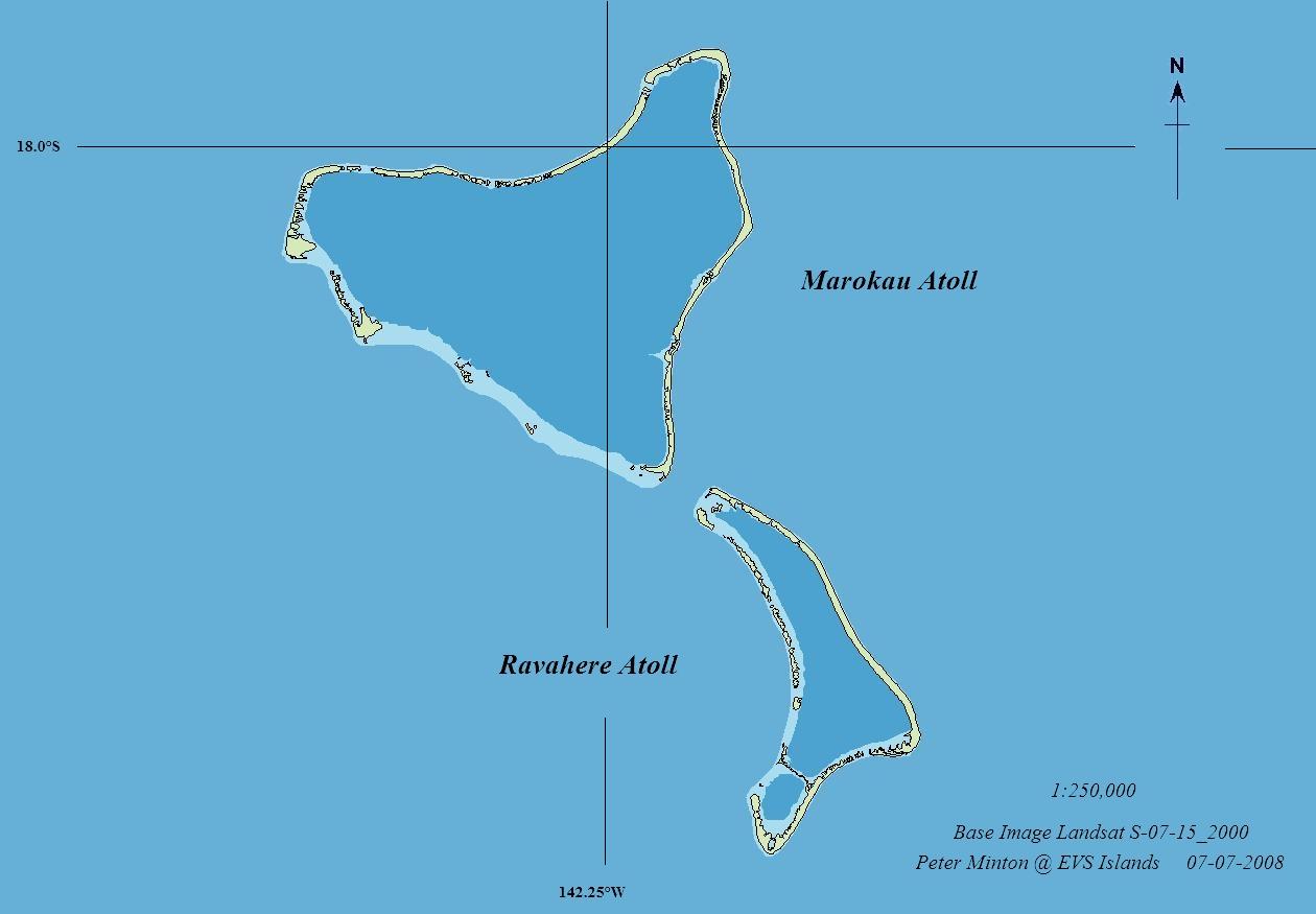
Ravahere is an atoll of the Tuamotu Archipelago in French Polynesia. It is located 53 km northwest of Nengonengo Atoll and it is separated by a 2 km sound from Marokau Atoll, its closest neighbor to the north.
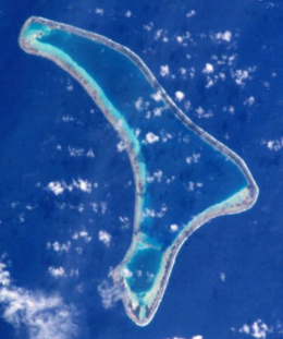 NASA picture of Ravahere Atoll | |
 Ravahere | |
| Geography | |
|---|---|
| Location | Pacific Ocean |
| Coordinates | 18°13′S 142°09′W |
| Archipelago | Tuamotus |
| Area | 57.5 km2 (22.2 sq mi) (lagoon) 7 km2 (3 sq mi) (above water) |
| Length | 20 km (12 mi) |
| Width | 9.5 km (5.9 mi) |
| Administration | |
| Overseas collectivity | |
| Administrative subdivision | Tuamotus |
| Commune | Hikueru |
| Demographics | |
| Population | Uninhabited[1] (2012) |
Marokau and Ravahere form a minor subgroup of the Tuamotus known as the Two Groups Islands.
Ravahere Atoll is roughly boomerang-shaped. It measures 20 km in length with a maximum width of 9.5 km. The shallow lagoon has a surface area of 57.5 km2, but there is no pass to enter it.
Ravahere is permanently uninhabited.
History
The first recorded European who sighted the two neighboring atolls of Marokau and Ravahere was Louis Antoine de Bougainville in 1768.[2]
Administration
Ravahere belongs to the commune of Hikueru, which consists of the atolls of Hikueru, Marokau, Ravahere, Reitoru and Tekokota.
Gallery
 Map of Marokau and Ravahere atolls
 NASA picture of Ravahere atoll

See also
- Desert island
- List of islands
References
- "Population". Institut de la statistique de la Polynésie française. Retrieved 16 October 2014.
- Robson, John (2005). "A short biography of Louis-Antoine de Bougainville". Archived from the original on 2008-02-27. Retrieved 2008-03-03.
External links
- Ravahere on Oceandots.com at the Wayback Machine (archived December 23, 2010)
- Photos
- Atoll list (in French)
Tuamotu Archipelago and Gambier Islands of French Polynesia | |||
|---|---|---|---|
Tuamotus Gambiers | Islands/Atolls | ||
| Island groups | |||
| Authority control |
|
|---|
This French Polynesia-related geography article is a stub. You can help Wikipedia by expanding it. |
На других языках
[de] Ravahere
Ravahere (alter Name: Dawhaida oder Dawhaida Island) ist ein unbewohntes Atoll des Tuamotu-Archipels in Französisch-Polynesien. Es liegt 53 km nordwestlich von Nengonengo entfernt und ist nur durch eine 2 km breite Wasserstraße von Marokau getrennt. Die bumerangähnliche Insel hat eine Länge von 18 km Länge mit maximal 7,5 km Breite. Die Lagune des Atolls hat keinen schiffbaren Zugang zum Meer.- [en] Ravahere
[fr] Ravahere
Ravahere est un atoll situé dans l'archipel des Tuamotu en Polynésie française qui constitue avec Marokau, distant au nord de 2 km, le sous-groupe des Îles Deux Groupes[2]. Il fait administrativement partie de la commune de Hikueru.[it] Ravahere
Ravahere è un atollo appartenente all'arcipelago delle Isole Tuamotu nella Polinesia francese, localizzato 53 km a nord-ovest dell'atollo di Nengo Nengo. È separato da uno stretto ampio 2 km dall'atollo di Marokau, la terra più prossima a nord.[ru] Равахере
Равахере (фр. Ravahere) — атолл в архипелаге Туамоту (Французская Полинезия) в группе островов Дье-Груп. Расположен в 2 км к югу от атолла Марокау.Другой контент может иметь иную лицензию. Перед использованием материалов сайта WikiSort.org внимательно изучите правила лицензирования конкретных элементов наполнения сайта.
WikiSort.org - проект по пересортировке и дополнению контента Википедии