geo.wikisort.org - Island
Tepoto Atoll (Tepoto Sud), or Ti Poto, is a small atoll of the Tuamotu Archipelago in French Polynesia. It is located 44 kilometres (27 miles) southwest of Makemo Atoll.
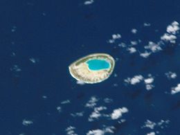
 NASA picture of Tepoto Atoll | |
 Tepoto (South) | |
| Geography | |
|---|---|
| Location | Pacific Ocean |
| Coordinates | 16°48′S 144°16′W |
| Archipelago | Tuamotus |
| Area | 2.5 km2 (0.97 sq mi) (lagoon) 0.6 square kilometres (0.2 square miles) (above water) |
| Length | 3.8 km (2.36 mi) |
| Width | 3.8 km (2.36 mi) |
| Administration | |
France | |
| Overseas collectivity | French Polynesia |
| Administrative subdivision | Tuamotus |
| Commune | Makemo |
| Demographics | |
| Population | Uninhabited[1] (2012) |
Tepoto Atoll is almost round in shape. It measures 3.8 kilometres (2 miles) in diameter. Its lovely turquoise-blue lagoon is connected to the ocean by a narrow channel in the north-east.
This atoll is sometimes called Tepoto Sud in French, to distinguish it from the island of Tepoto, approximately 400 kilometres (249 miles) to the northeast in the Disappointment Islands.
The small group formed by Tepoto Sud, Hiti and Tuanake is also known as the "Raevski Atolls". The Tuamotu reed warbler and the Polynesian ground dove are found in this area.
Tepoto Atoll is permanently uninhabited.
According to articles in Ireland's Own and the Times Educational Supplement Website, the atoll is identified by Tony Crowley as being the site of buried treasure stolen during the 19th century by four adventurers from a church in Pisco, Peru. Over the years, people have searched for the treasure without success, though an Australian visitor to the atoll discovered a cache of medallions, the contents of which indicated they came from South America.
History
Tepoto Sud was sighted by French explorer Louis-Antoine de Bougainville in 1768, but the first European to land was Russian explorer Fabian Gottlieb von Bellingshausen in 1820.
Administration
Tepoto Sud belongs to the commune of Makemo, which consists of the atolls of Makemo, Haraiki, Marutea Nord, Katiu, Tuanake, Hiti, Tepoto Sud, Raroia, Takume, Taenga and Nihiru.
References
Notes
- "Population". Institut de la statistique de la Polynésie française. Retrieved 23 September 2014.
Sources
External links
На других языках
[de] Tepoto Sud
Tepoto Sud, auch Ti Poto genannt, ist ein Atoll des Tuamotu-Archipels in Französisch-Polynesien. Tepoto Sud liegt 44 km südwestlich vom Makemo-Atoll entfernt. Das vergleichsweise kleine Atoll hat eine runde Form mit einem Durchmesser von etwa 3,8 km sowie einer Landfläche von nur 0,6 km². Die 2,5 km² große Lagune verfügt über einen schiffbaren Zugang zum Meer im Nordosten. Das Atoll erhielt seinen Zusatz Sud um es von einem gleichnamigen 400 km entfernten Atoll im Norden, Tepoto Nord, abzugrenzen. Tepoto Sud gehört administrativ zur Gemeinde Makemo und dort zur Teilgemeinde („Commune associées“) Katiu.- [en] Tepoto (South)
[fr] Tepoto Sud
Tepoto Sud ou Ti Poto[2] est un atoll du sous-groupe des Îles Raevski situé dans l'archipel des Tuamotu en Polynésie française. Il est appelé ainsi pour le différencier de Tepoto Nord, situé à 425 km au nord-est.[it] Tepoto Sud
Tepoto Sud è un atollo appartenente all'arcipelago delle Isole Tuamotu nella Polinesia francese.[ru] Южный Тепото
Южный Тепото (фр. Tepoto Sud) — атолл в архипелаге Туамоту (Французская Полинезия). Расположен в 20 км к юго-западу от острова Хити.Другой контент может иметь иную лицензию. Перед использованием материалов сайта WikiSort.org внимательно изучите правила лицензирования конкретных элементов наполнения сайта.
WikiSort.org - проект по пересортировке и дополнению контента Википедии