geo.wikisort.org - Island
Akiaki[2] is a low coral atoll in the eastern area of the Tuamotu Archipelago, French Polynesia. Akiaki's nearest neighbor is Vahitahi, which is located 41 km to the southeast.
 Map of Akiaki Atoll | |
 Akiaki | |
| Geography | |
|---|---|
| Location | Pacific Ocean |
| Coordinates | 18°33′S 139°13′W |
| Archipelago | Tuamotus |
| Area | 1.3 km2 (0.50 sq mi) |
| Length | 2 km (1.2 mi) |
| Width | 0.9 km (0.56 mi) |
| Administration | |
France | |
| Overseas collectivity | French Polynesia |
| Administrative subdivision | Tuamotus |
| Commune | Nukutavake |
| Demographics | |
| Population | 13[1] (2020) |
Akiaki is a small atoll rising barely above sea level. The total land surface is only 1.3 km2. Its reef is occupied by a single flat island covered with coconut trees and other vegetation. There is no lagoon and it has only a difficult landing located on its northwestern side.
Akiaki is barely inhabited with a rough total of 13 residents, its occasionally visited by tourists for its coconut plantations. Akiaki maintains a small fishing port used by the residents as their source of revenue.
History
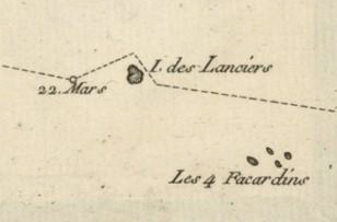
The first recorded European that arrived to Akiaki Atoll was Louis Antoine de Bougainville on 22 March 1768.[3] He called this atoll Ile des Lanciers. James Cook reached Akiaki the following year, during his first voyage, and named it Thrum Island.
Geology
Akiaki lies on top of a small seamount which is part of the Tuamotu Seamount Trail on the Pacific Plate. Akiaki's seamount is 3420 m high.
Administration
Administratively Akiaki Atoll belongs to the commune of Nukutavake, which includes Nukutavake, as well as the atolls of Vahitahi, Vairaatea, Pinaki and Akiaki.
See also
- Desert island
- List of islands
References
- "Population". Institut de la statistique de la Polynésie française. Retrieved 23 September 2014.
- Young, J.L. (1899). "Names of the Paumotu Islands, with the old names so far as they are known". Journal of the Polynesian Society. 8 (4): 264–268. Retrieved 7 January 2015.
- Salmond, Anne (2010). Aphrodite's Island. Berkeley: University of California Press. pp. 93. ISBN 9780520261143.
Tuamotu Archipelago and Gambier Islands of French Polynesia | |||
|---|---|---|---|
Tuamotus Gambiers | Islands/Atolls | ||
| Island groups | |||
| |||
This French Polynesia-related geography article is a stub. You can help Wikipedia by expanding it. |
На других языках
[de] Akiaki
Akiaki, alte Namen Thrum Cap Island und Île des Lanciers, ist eine kleine, heute unbewohnte Insel im Südosten des Pazifischen Ozeans. Sie liegt in der zentral-östlichen Gruppe des Tuamotu-Archipels und gehört politisch zu Französisch-Polynesien. Die nächste bewohnte Insel ist das rund 50 km im Südosten liegende Vahitahi.- [en] Akiaki
[fr] Akiaki
Akiaki est un atoll de corail situé à l'est de l'archipel des Tuamotu en Polynésie française. Il est administrativement rattaché à la commune de Nukutavake.[it] Akiaki
Akiaki è un atollo corallino dell'arcipelago delle isole Tuamotu nella Polinesia francese. Possiede una superficie di soli 1,3 km²[ru] Акиаки
Акиаки (фр. Akiaki) — атолл в архипелаге Туамоту (Французская Полинезия). Расположен в 130 км к северо-западу от атолла Нукутаваке, в 160 км к востоку от атолла Хао и в 45 км к северо-западу от атолла Вахитахи.Другой контент может иметь иную лицензию. Перед использованием материалов сайта WikiSort.org внимательно изучите правила лицензирования конкретных элементов наполнения сайта.
WikiSort.org - проект по пересортировке и дополнению контента Википедии