geo.wikisort.org - Island
Taravai is the second largest island in the Gambier Islands of French Polynesia, at 5.7 km2. Taravai is about 1.5 km southwest of Mangareva and about 300 m north of the island of Angakauitai. Off its eastern shore lies the tiny rock Îlot Motu-o-ari.
 View of Taravai | |
 Taravai | |
| Geography | |
|---|---|
| Location | Pacific Ocean |
| Coordinates | 23°08′12″S 135°01′33″W |
| Archipelago | Tuamotus |
| Area | 5.7 km2 (2.2 sq mi) |
| Highest elevation | 256 m (840 ft) |
| Highest point | (unnamed) |
| Administration | |
France | |
| Overseas collectivity | French Polynesia |
| Administrative subdivision | Tuamotus |
| Commune | Gambier Islands |
| Largest settlement | Agonoko |
| Demographics | |
| Population | 9[1] (2012) |
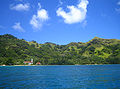
The village named Agonoko is located near the main bay on the island's eastern shore. It has a population of 9 (as of 2012[update]). Former villages were Aga-nui (northwest) and Agakau-i-uta (southeast).[2]
The Onemea archaeological site suggests sporadic occupation of the island around AD 950 with a possible continuous settlement since the 13th century.[3]
Before the conversion to Christianity, the king of Taravai was a vassal to the king of Rikitea in Mangareva.[4]
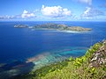 View of Taravai and Angakauitai from Mont Mokoto
 Church of Saint-Gabriel
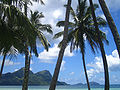
 Taravai


References
- "Population". Institut de la statistique de la Polynésie française. Retrieved 14 October 2014.
- Goodbye Gambiers
- The Onemea site (Taravai Island, Mangareva) and the human colonization of Southeastern Polynesia. Archaeology in Oceania
- R. W. Williamson, The Social and Political Systems of Central Polynesia, Cambridge University Press, 1924
External links
Tuamotu Archipelago and Gambier Islands of French Polynesia | |||
|---|---|---|---|
Tuamotus Gambiers | Islands/Atolls | ||
| Island groups | |||
This French Polynesia-related geography article is a stub. You can help Wikipedia by expanding it. |
На других языках
[de] Taravai
Taravai ist die zweitgrößte der Gambierinseln in Französisch-Polynesien.- [en] Taravai
[es] Taravai
La Taravai es la segunda isla más grande de las Islas Gambier en la Polinesia Francesa, con una superficie de 5,7 km². Taravai está situada a unos 1,5 km al suroeste de Mangareva, y unos 300 m al norte de la isla de Angakauitai. Fuera de su orilla oriental se encuentra la pequeña roca Îlot Motu-o-ari (Islote Motuoari).[fr] Taravai
Taravai est une île située dans les Îles Gambier en Polynésie française. C'est la deuxième plus importante par sa superficie[ru] Тараваи
Тараваи (фр. Taravai) — второй по величине остров в составе островов Гамбье.Другой контент может иметь иную лицензию. Перед использованием материалов сайта WikiSort.org внимательно изучите правила лицензирования конкретных элементов наполнения сайта.
WikiSort.org - проект по пересортировке и дополнению контента Википедии