 Image Source: ISS005-E-13941
 Image Source: Landsat S-06-15_2000 (1:115,000)
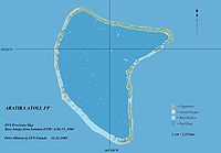 Map Source: EVS Precision Map (1:150,000)
geo.wikisort.org - Island
Aratika[2] is an atoll in the Tuamotu group in French Polynesia. The nearest land is Kauehi Atoll, located 35 km to the south east.
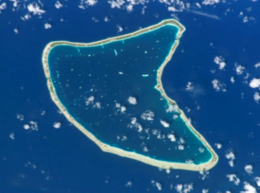 NASA picture of Aratika Atoll | |
 Aratika | |
| Geography | |
|---|---|
| Location | Pacific Ocean |
| Coordinates | 15°32′S 145°32′W |
| Archipelago | Tuamotus |
| Area | 145 km2 (56 sq mi) (lagoon) 8.3 km2 (3 sq mi) (above water) |
| Length | 20.8 km (12.92 mi) |
| Width | 10.7 km (6.65 mi) |
| Administration | |
France | |
| Overseas collectivity | French Polynesia |
| Administrative subdivision | Îles Tuamotu-Gambier |
| Commune | Fakarava |
| Largest settlement | Paparara |
| Demographics | |
| Population | 160[1] (2012) |
| Pop. density | 19/km2 (49/sq mi) |

Aratika has an unusual butterfly shape. Its length is 20.8 km2 (8.0 sq mi) and its maximum width 10.7 km2 (4.1 sq mi) . It has a land area of approximately 8.3 km2 (3.2 sq mi) . The lagoon is wide and deep, and can be entered by two navigable passes.[3]
Aratika had 160 inhabitants in 2012. The main village is called Paparara.
History
Aratika appears in some maps as "Carlshoff Island". This atoll was visited by the Charles Wilkes expedition on September 3, 1839. Prior to the pearl market slump at the turn of the century, Aratika was home to about 2000 people, thereafter dropping to about 200.
Aratika has a private airfield which opened in 1998 and is owned by the Fourcade company. Much of the island's main infrastructure, including the school in 2004 and many business from Paparara village were moved there due to ease of access to and from the airstrip.
The population number has been slowly declining and halves when the children go to school from the age of 11 as there is only a primary school on the island which has one class for 3-11 year olds.
Administration
Aratika Atoll belongs to the commune of Fakarava, which consists of Fakarava, as well as the atolls of Aratika, Kauehi, Niau, Raraka, Taiaro and Toau.
Images & Maps


References
- "Population". Institut de la statistique de la Polynésie française. Retrieved 24 September 2014.
- Young, J.L. (1899). "Names of the Paumotu Islands, with the old names so far as they are known". Journal of the Polynesian Society. 8 (4): 264–268. Archived from the original on 10 February 2012. Retrieved 7 January 2015.
- Cruising World. 1979. p. 3-PA92. Retrieved February 28, 2018.
- Pictures
- Aratika-Nord Airport
- Charles Wilkes Expedition (in French)
External links
- Aratika Atoll FP (EVS Islands)
- Shuttle Image ISS005-E-13941 (Astronaut Photography)
- "Aratika Atoll FP (Oceandots.com)". Archived from the original on December 23, 2010. Retrieved March 14, 2009.
{{cite web}}: CS1 maint: bot: original URL status unknown (link) - Tuamotu Atolls List (Pacific Image)
Tuamotu Archipelago and Gambier Islands of French Polynesia | |||
|---|---|---|---|
Tuamotus Gambiers | Islands/Atolls | ||
| Island groups | |||
| |||
| Authority control |
|
|---|
This French Polynesia-related geography article is a stub. You can help Wikipedia by expanding it. |
На других языках
[de] Aratika
Aratika ist ein Atoll des Tuamotu-Archipels in Französisch-Polynesien. Das Atoll gehört administrativ zur Gemeinde Fakarava. Aratika liegt 34 km nordöstlich von Kauehi und 47 km nordnordöstlich von Fakarava. Die Form des Atolls ähnelt einem Schmetterling, es erreicht eine Ausdehnung von 20,8 × 10,7 km. Die tiefe, 145 km² große Lagune besitzt zwei schiffbare Zugänge zum Meer.- [en] Aratika
[fr] Aratika
Aratika est un atoll situé dans l'archipel des îles Tuamotu en Polynésie française dans le sous-groupe des îles Palliser. Il est administrativement rattaché à la commune de Fakarava. Depuis 1977, Aratika fait partie des sept atolls de la commune de Fakarava classés réserve de biosphère par l’UNESCO[2].[it] Aratika
Aratika è un atollo appartenente all'arcipelago delle isole Tuamotu nella Polinesia francese. Da un punto di vista amministrativo fa parte del comune di Fakarava. La sua laguna si estende su una superficie di 145 km².[ru] Аратика
Аратика (фр. Aratica) — атолл в архипелаге Туамоту (Французская Полинезия). Атолл расположен в 47 км к северу от атолла Факарава и в 35 км к северо-востоку от атолла Кауэхи.Текст в блоке "Читать" взят с сайта "Википедия" и доступен по лицензии Creative Commons Attribution-ShareAlike; в отдельных случаях могут действовать дополнительные условия.
Другой контент может иметь иную лицензию. Перед использованием материалов сайта WikiSort.org внимательно изучите правила лицензирования конкретных элементов наполнения сайта.
Другой контент может иметь иную лицензию. Перед использованием материалов сайта WikiSort.org внимательно изучите правила лицензирования конкретных элементов наполнения сайта.
2019-2026
WikiSort.org - проект по пересортировке и дополнению контента Википедии
WikiSort.org - проект по пересортировке и дополнению контента Википедии