geo.wikisort.org - Insel
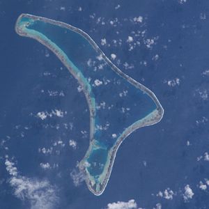
Ravahere (alter Name: Dawhaida oder Dawhaida Island) ist ein unbewohntes Atoll des Tuamotu-Archipels in Französisch-Polynesien. Es liegt 53 km nordwestlich von Nengonengo entfernt und ist nur durch eine 2 km breite Wasserstraße von Marokau getrennt. Die bumerangähnliche Insel hat eine Länge von 18 km Länge mit maximal 7,5 km Breite. Die Lagune des Atolls hat keinen schiffbaren Zugang zum Meer.
| Ravahere | ||
|---|---|---|
 | ||
| Gewässer | Pazifischer Ozean | |
| Archipel | Tuamotu-Archipel | |
| Geographische Lage | 18° 13′ S, 142° 9′ W | |
|
| ||
| Anzahl der Inseln | – | |
| Landfläche | 70 ha | |
| Lagunenfläche | 5,1 km² | |
| Einwohner | unbewohnt | |
Ravahere und Marokau bilden die sogenannten Îles Deux Groupes. Ravahere gehört zur Gemeinde Hikueru.
Sie ist wahrscheinlich mit der am 24. März 1768 von Louis Antoine de Bougainville entdeckten Insel Marokau (auch Marakau) identisch.[1]
Einzelnachweise
- Andrew Sharp: The Discovery of the Pacific Islands. Oxford University Press 1960, S. 115
Weblinks
Commons: Ravahere – Sammlung von Bildern, Videos und Audiodateien
- Bild und Kurzbeschreibung (Memento vom 23. Dezember 2010 im Internet Archive) (englisch)
- Reiseimpressionen vom Atoll und Korallenriffen (englisch)
На других языках
- [de] Ravahere
[en] Ravahere
Ravahere is an atoll of the Tuamotu Archipelago in French Polynesia. It is located 53 km northwest of Nengonengo Atoll and it is separated by a 2 km sound from Marokau Atoll, its closest neighbor to the north.[fr] Ravahere
Ravahere est un atoll situé dans l'archipel des Tuamotu en Polynésie française qui constitue avec Marokau, distant au nord de 2 km, le sous-groupe des Îles Deux Groupes[2]. Il fait administrativement partie de la commune de Hikueru.[it] Ravahere
Ravahere è un atollo appartenente all'arcipelago delle Isole Tuamotu nella Polinesia francese, localizzato 53 km a nord-ovest dell'atollo di Nengo Nengo. È separato da uno stretto ampio 2 km dall'atollo di Marokau, la terra più prossima a nord.[ru] Равахере
Равахере (фр. Ravahere) — атолл в архипелаге Туамоту (Французская Полинезия) в группе островов Дье-Груп. Расположен в 2 км к югу от атолла Марокау.Текст в блоке "Читать" взят с сайта "Википедия" и доступен по лицензии Creative Commons Attribution-ShareAlike; в отдельных случаях могут действовать дополнительные условия.
Другой контент может иметь иную лицензию. Перед использованием материалов сайта WikiSort.org внимательно изучите правила лицензирования конкретных элементов наполнения сайта.
Другой контент может иметь иную лицензию. Перед использованием материалов сайта WikiSort.org внимательно изучите правила лицензирования конкретных элементов наполнения сайта.
2019-2025
WikiSort.org - проект по пересортировке и дополнению контента Википедии
WikiSort.org - проект по пересортировке и дополнению контента Википедии
