geo.wikisort.org - Reservoir
The IJsselmeer[lower-alpha 1] (Dutch: [ɛisəlˈmeːr]; West Frisian: Iselmar, Dutch Low Saxon: Iesselmeer), also known as Lake IJssel in English,[2] is a closed off inland bay in the central Netherlands bordering the provinces of Flevoland, North Holland and Friesland. It covers an area of 1,100 km2 (420 sq mi) with an average depth of 5.5 m (18 ft). The river IJssel flows into the IJsselmeer.
| IJsselmeer | |
|---|---|
 Sentinel-2 photo | |
 IJsselmeer | |
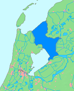 IJsselmeer in dark blue | |
| Location | Netherlands |
| Coordinates | 52°49′N 5°15′E |
| Primary inflows | IJssel, Overijsselse Vecht |
| Primary outflows | Wadden Sea (which empties into the North Sea) |
| Surface area | 1,100 km2 (420 sq mi) |
| Average depth | 5.5 m (18 ft) |
| Max. depth | 7 m (23 ft) |
| Surface elevation | −0.4 m (−1.3 ft) (winter) −0.2 m (−0.66 ft) (summer) |
Ramsar Wetland | |
| Designated | 29 August 2000 |
| Reference no. | 1246[1] |

History
This section needs additional citations for verification. (July 2021) |


Two thousand years ago Pomponius Mela, a Roman geographer, mentioned a complex of lakes at the current location of the IJsselmeer. He called it Lacus Flevo.[3] Over the centuries, the lake banks crumbled away due to flooding and wave action and the lake grew considerably. During the 12th and 13th centuries, storm surges and rising sea levels flooded large areas of land between the lake and the North Sea, turning the lake into a bay of the North Sea, called the Zuiderzee. The Zuiderzee continued to be a threat to the Dutch, especially when northwesterly storms funnel North Sea waters towards the English Channel, creating very high tides along the Dutch coast. During the 17th century, Zuiderzee dykes collapsed several times and plans were drawn up to eliminate the threat by draining the bay. Later drainage plans focused on creating fertile farmland, but they never progressed beyond the planning stage. It was only after the flood of 1916 that the legislature approved the Zuiderzee Works, a major hydraulic engineering project that involved building dykes, draining parts of the Zuiderzee and constructing the Afsluitdijk to keep tides and high water out.
In 1932 the Zuiderzee was closed off by the Afsluitdijk, a 32-kilometre (20 mi) dyke connecting Friesland and North Holland on either side of the Zuiderzee. The Zuiderzee was no longer a sea inlet and was renamed IJsselmeer (Lake IJssel). The continuing flow of fresh riverwater soon flushed out the saltwater.
From 1929 till 1967, over half the IJsselmeer was drained, creating 1,979 km2 (764 sq mi) of polders:[4] Wieringermeerpolder, Noordoostpolder, East and South Flevoland.
In 1975, a dyke was built between Enkhuizen and Lelystad as the northern boundary of the Markerwaard, a planned but never realized polder in the IJsselmeer. This dyke, the Houtribdijk or Markerwaarddijk, split the IJsselmeer in two parts. The former southern part of the IJsselmeer is now the hydrologically separate Markermeer. The proposed polderisation of the Markerwaard was abandoned after many of the Dutch population did not want the loss of the traditional seaside (now lakeside) environment and vistas.
In 1986 three polders in the IJsselmeer constituted the new province of Flevoland, the twelfth province of the Netherlands.
The water of the IJsselmeer is now almost completely fresh, the saline having long since been purged. This altered environment has had an impact upon the fish and plant ecosystems. The change has been beneficial for Dutch boats, many of which are steel, as the fresh water significantly reduces rusting of the hulls, and there is far less build-up of marine growth (such as algae and barnacles below the barges' waterlines). This has the knock-on benefit that barges and yachts in the IJsselmeer need far less antifouling, a coating which is inevitably somewhat toxic to wildlife.
Current use
Due to considerable amounts of water from the Rhine flowing through its distributary IJssel into the IJsselmeer, the closed off bay functions as a large freshwater reservoir, serving as a source for agriculture and drinking water. Outlet sluices in the Afsluitdijk regulate the water level of the IJsselmeer.[citation needed]
The IJsselmeer is used for transport and fishing. It also offers a number of opportunities for recreational activity, both on the water and on its shores. Due to the shallowness of the IJsselmeer, the Markermeer and the bordering lakes, its cities and fishing villages remained mostly unspoilt and have many historical buildings.[5]
The IJsselmeer is home to the offshore segments of Windpark Noordoostpolder. In the future, Windpark Fryslan will also be built in this bay.[6]
See also
- Ketelmeer, a small bay between the IJsselmeer and the mouth of the river IJssel.
- IJsseloog, an artificial island in the Ketelmeer, built as a repository for contaminated silt.
- Lake Flevo
- Almere (lake)
- Zuiderzee
- Markermeer
Notes
- I and J at the start of the name are both capitalized because the combination is a digraph in Dutch and thus considered a single letter.
References
- "IJsselmeer". Ramsar Sites Information Service. Retrieved 25 April 2018.
- "IJsselmeer". Merriam-Webster Dictionary. Retrieved 1 May 2019.
- Ley, Willy (October 1961). "The Home-Made Land". For Your Information. Galaxy Science Fiction. pp. 92–106.
- "Earthshots | Earth Resources Observation and Science (EROS) Center". Eros.usgs.gov. Retrieved 26 April 2022.
- "Authentic villages around IJsselmeer". Holland.com. Retrieved 26 April 2022.
- "Windpark Fryslân Offshore Wind Farm - Fully Commissioned - Netherlands | 4C Offshore". 4coffshore.com. Retrieved 26 April 2022.
Authority control | |
|---|---|
| General |
|
| National libraries | |
| Other |
|
На других языках
[de] IJsselmeer
Das IJsselmeer (Eisselmeer, Ysselmeer; [.mw-parser-output .IPA a{text-decoration:none}ˌɛi̯səlˈmeːr]; das IJ ist im Niederländischen ein besonderer Digraph, weshalb auch das J als Majuskel geschrieben wird) ist der größte See der Niederlande. Der durch Eindeichung künstlich entstandene heutige Süßwassersee besteht aus einem großen Teilgebiet der ehemaligen Meeresbucht Zuiderzee zwischen Friesland und Noord-Holland. Das Wort Meer hat im Niederländischen (wie im Niederdeutschen) die Bedeutung von „Binnensee“. Der See ist benannt nach seinem Hauptzufluss, der (Gelderschen) IJssel (Gelderse IJssel), die unterhalb von Kampen in das Nebengewässer Ketelmeer einmündet. In den damit verbundenen See Zwarte Meer mündet der zweitgrößte Zufluss, das Zwarte Water.- [en] IJsselmeer
[es] IJsselmeer
El IJsselmeer (o lago del IJssel, por el nombre del río IJssel,[1] que lo alimenta a través de un lago menor, el Ketelmeer) es el lago más importante de los Países Bajos, un lago artificial localizado en el centro del país que anteriormente era parte del Zuiderzee («mar del sur»), un antiguo entrante poco profundo del mar del Norte. Sus riberas pertenecen a las provincias de Flevoland, Holanda Septentrional y Frisia. Tiene una superficie de 1100 km² y poca profundidad, con una media de entre 5 y 6 m y una máxima de 9,5 m por encima del NAP, cerca de la costa frente a Lelystad.[fr] IJsselmeer
L'IJsselmeer — ou en français, lac de l'IJssel ou lac de l'Yssel — est, avec une superficie de 1 100 km2, le plus important lac des Pays-Bas. Le point le plus profond se trouve au large des rives de Lelystad, à 9,5 mètres au-dessous du niveau normal d'Amsterdam (NAP).[ru] Эйсселмер
Эйсселме́р (нидерл. IJsselmeer [ˌɛi̯səlˈmeːr]) — искусственное пресное озеро в центральных Нидерландах на месте бывшего залива Зёйдерзе. Граничит с провинциями Фрисландия на северо-востоке, Флеволанд на юге и востоке и Северная Голландия на западе. От Северного моря на севере отделено 32-километровой дамбой толщиной около 60 метров. Общая площадь озера — около 1100 км², средняя глубина от 5 до 6 метров. Водоём получил своё название от реки Эйссел, впадающей в него через небольшое озеро Кетелмер. Эйсселмер — крупнейший по площади пресноводный водоём Западной Европы.Другой контент может иметь иную лицензию. Перед использованием материалов сайта WikiSort.org внимательно изучите правила лицензирования конкретных элементов наполнения сайта.
WikiSort.org - проект по пересортировке и дополнению контента Википедии