geo.wikisort.org - River
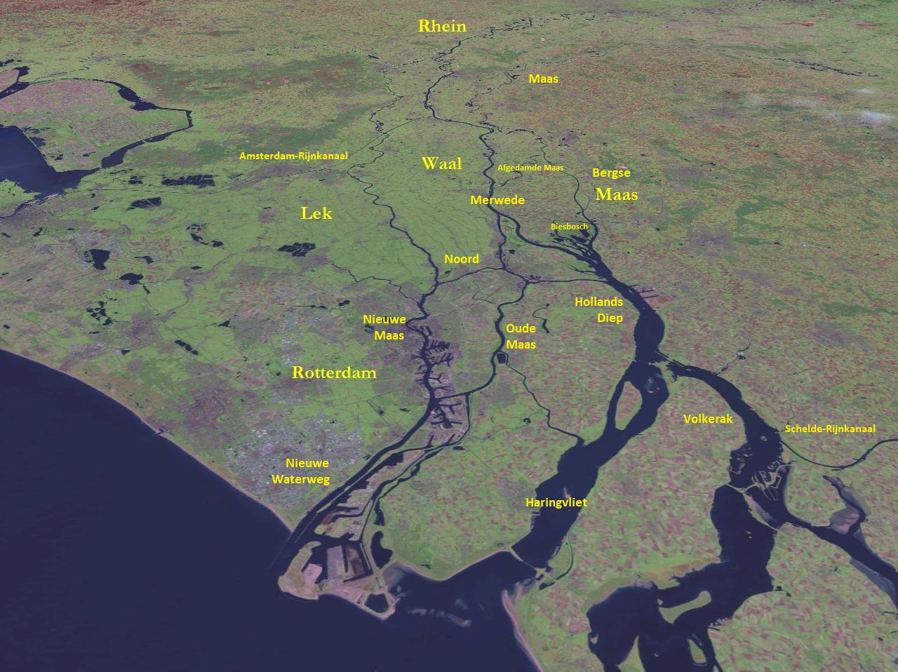
The Nieuwe Maas (Dutch pronunciation: [ˌniuə ˈmaːs]; "New Meuse") is a distributary of the Rhine River, and a former distributary of the Maas River, in the Dutch province of South Holland. It runs from the confluence of the rivers Noord and Lek, and flows west through Rotterdam. It ends west of the city where it meets the Oude Maas ("Old Meuse"), near Vlaardingen, to form Het Scheur. After a few miles, the Scheur continues as the artificial Nieuwe Waterweg. The total length of the Nieuwe Maas (excluding the Scheur) is approximately 24 kilometres (15 mi).
| Nieuwe Maas New Meuse | |
|---|---|
 Nieuwe Maas in the heart of Rotterdam | |
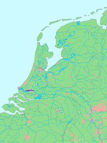 Location of Nieuwe Maas in dark blue | |
| Location | |
| Country | Netherlands |
| Physical characteristics | |
| Source | Lek / Noord |
| • location | Ridderkerk |
| Mouth | Het Scheur |
• location | Vlaardingen |
| Length | 24 km (15 mi) |
Geography

The Nieuwe Maas flows through some of the most densely populated and developed areas in the Netherlands. Along its shores are numerous harbours and industries.
History
During the early Middle Ages the river was considered to be the continuation of the Merwede river (itself a distributary branch of the Rhine) and was named accordingly. However, during the 13th century a series of floods forced the Maas to shift its main course north towards the Merwede. From then on, several stretches of the original Merwede were named Maas instead, including the current Nieuwe Maas.
In the late 19th century the connection between the Maas and Rhine was closed off entirely (the current Afgedamde Maas) and the Maas was given a new, artificial mouth - the Bergse Maas. The resulting separation of the rivers Rhine and Maas reduced the risk of flooding and is considered to be the greatest achievement in Dutch hydraulic engineering before the completion of the Zuiderzee Works and Delta Works.[1][2] From that moment on, the Nieuwe Maas is only fed by the Rhine.
River crossings

From west to east:
- Beneluxtunnel (tunnel; motor vehicles, cyclists and metro)
- Maastunnel (tunnel; motor vehicles, cyclists, pedestrians)
- Erasmusbrug (bridge; motor vehicles, cyclists, pedestrians, trams)
- Maastaxi (ferry; pedestrians)
- Metrotunnel (tunnel; metro)
- Willemstunnel (tunnel; train)
- Willemsbrug (bridge; motor vehicles, cyclists, pedestrians)
- Van Brienenoordbrug (bridge; motor vehicles, cyclists, pedestrians)
References
- Van der Aalst & De Jongh (2004). Honderd Jaar Bergse Maas (in Dutch). Pictures Publishing. ISBN 90 73187 50 8.
- Wols, Rien (2011). "De Uitvoering van de Maasmondingswerken". Brabants Historisch Informatie Centrum (in Dutch).
На других языках
[de] Nieuwe Maas
Die Nieuwe Maas (deutsch Neue Maas) ist ein rund 24 Kilometer langer Teil eines Hauptstroms im Rheindelta. Namensgebend ist die Maas, mit deren früherer Mündung (heute Oude Maas) sich die Nieuwe Maas vereinigt. Die Nieuwe Maas beginnt als die bei Slikkerveer stattfindende Vereinigung des breiten Rheinarmes Lek und der schmaleren Noord, die vom Rheinarm Waal abzweigt. Sie passiert Rotterdam mit dem drittgrößten Hafen der Welt, der auch von Seeschiffen befahren wird und ein wichtiger Umschlagplatz ist. Die Nieuwe Maas und die von links hinzugekommene Oude Maas fließen zusammen als Nieuwe Waterweg zur Nordsee, die bei Hoek van Holland erreicht wird.- [en] Nieuwe Maas
[it] Nieuwe Maas
Il Nieuwe Maas (in italiano Nuova Mosa) è un fiume dei Paesi Bassi nel bacino del delta del Reno, della Mosa e della Schelda. Scorre interamente nella provincia dell'Olanda Meridionale. È un effluente del Reno e, in passato, lo è stato anche della Mosa.[ru] Ньиве-Маас
Ньиве-Маас (нидерл. Nieuwe Maas, МФА: [ˈniwə ˈmaːs], «Новый Маас») — река в Нидерландах, рукав в дельте Рейна и Мааса. Начинается от деревни Киндердейк, где сливаются реки Норд и Лек, и течёт на запад сквозь Роттердам. Западнее Роттердама, в районе города Влардинген Ньиве-Маас сливается с рекой Ауде-Маас, образуя реку Схёр. Длина реки — 24 км.[источник не указан 1867 дней]Другой контент может иметь иную лицензию. Перед использованием материалов сайта WikiSort.org внимательно изучите правила лицензирования конкретных элементов наполнения сайта.
WikiSort.org - проект по пересортировке и дополнению контента Википедии