geo.wikisort.org - Reservoir
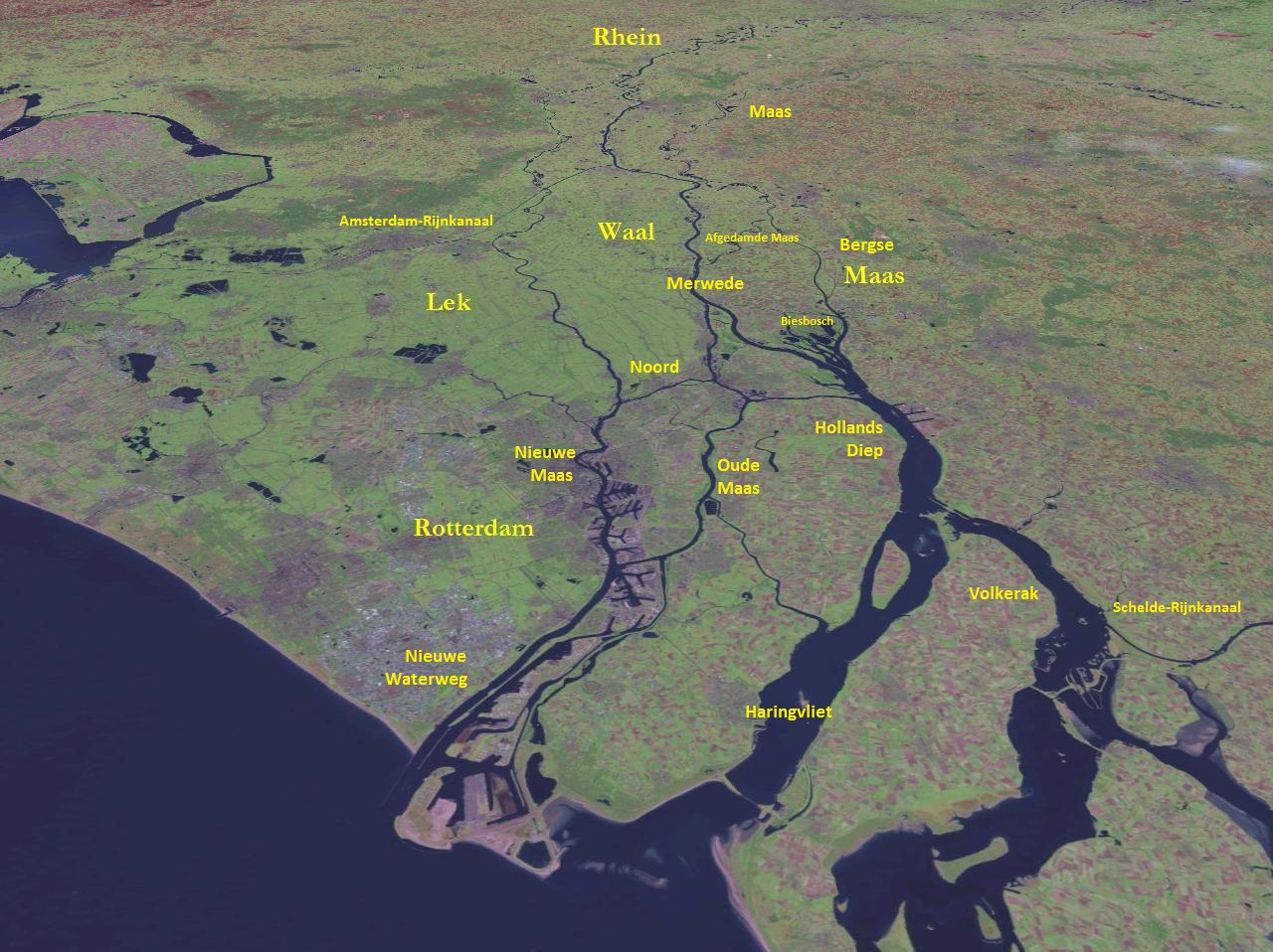
The Haringvliet is a large inlet of the North Sea, in the province of South Holland in the Netherlands. It is an important estuary of the Rhine-Meuse delta.[2]
| Designations | |
|---|---|
Ramsar Wetland | |
| Designated | 29 August 2000 |
| Reference no. | 1244[1] |

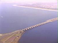
Near Numansdorp, the Hollands Diep splits into the Haringvliet and the Volkerak estuaries. It is closed off near Goedereede from the North Sea by the Haringvlietdam, which provides a road connection between the island of Voorne to the north and the island of Goeree-Overflakkee to the south.[3] The dam with its sluices was built as part of the Delta Works sea barrier protection works.[4]
The Haringvliet estuary contains the island of Tiengemeten, which is separated from the river island of Hoeksche Waard by the Vuile Gat strait.
History
The Haringvliet was formed as a result of the extensive flooding event of 1216, which breached the dunes of Voorne and created a deep saltwater inlet. During a second flooding event, the St. Elizabeth floods of 1421, this inlet connected to the Merwede and became an important estuary of the Rhine and Meuse rivers.
It used to be ecologically rich, and its brackish waters, fed by both rivers and sea, supported a healthy population of seals. It also provided an access point for migrating fish like salmon and sturgeon. As a result of the North Sea flood of 1953 the Haringvliet was closed off by the Haringvlietdam. The Haringvliet lost its estuarine characteristics and became a freshwater lake.[5] Because of that, the seals are gone and migrating fish can only enter the Rhine-Meuse Delta through the busy and heavy industrialised Nieuwe Waterweg.
There are plans to permanently open a few of the Haringvliet sluices, to partly restore the ecosystem.[6]
References
- "Haringvliet". Ramsar Sites Information Service. Retrieved 25 April 2018.
- "Haringvliet" (in Dutch). Rijkswaterstaat. Archived from the original on 2014-10-26.
- "N57 (Highway)" (in Dutch). Rijkswaterstaat. Archived from the original on 2014-10-26.
- "Haringvlietsluizen" (in Dutch). Rijkswaterstaat.[permanent dead link]
- "Haringvliet Expo". Deltawerken Online (in Dutch).
- "Haringvlietsluizen op een kier" (in Dutch). Rijkswaterstaat.
На других языках
[de] Haringvliet
Der Haringvliet ist ein küstennahes Binnengewässer in den Niederlanden (Zuid-Holland). Die seit 1970 abgedämmte einstige Meeresbucht trennt die einstigen Inseln Voorne-Putten und Hoeksche Waard im Norden von Goeree-Overflakkee im Süden. Der Haringvliet ist 28 Kilometer lang und zwischen 795 und 3150 Meter breit. Die mittlere Tiefe beträgt NAP-8m, die tiefste Stelle (bei Middelharnis) NAP-39m. Über den Haringvliet und die Sielanlagen des Sperrwerks erreichen der Hauptmündungsarm des Rheins, im untersten Abschnitt Nieuwe Merwede genannt, und die Maas gemeinsam die Nordsee. Ein weiteres Gewässer des Rhein-Maas-Deltas, die Spui, verbindet das Haringsvliet mit der Oude Maas (Hoeksche Waard und Voorne-Putten). Im Haringvliet liegt die Insel Tiengemeten.- [en] Haringvliet
[fr] Haringvliet (bras de mer)
Le Haringvliet est un ancien bras de mer de la mer du Nord, en Hollande-Méridionale entre Voorne-Putten et Hoeksche Waard au nord, et Goeree-Overflakkee au sud. Il reçoit les eaux du Hollands Diep qui est le nom donné à cet endroit à la Meuse. Il est barré par le Haringvlietdam qui le sépare de la mer du Nord.[ru] Харингвлит
Харингвлит (нидерл. Haringvliet) — большой узкий залив Северного моря, важный эстуарий в дельте Рейна и Мааса в нидерландской провинции Южная Голландия.Другой контент может иметь иную лицензию. Перед использованием материалов сайта WikiSort.org внимательно изучите правила лицензирования конкретных элементов наполнения сайта.
WikiSort.org - проект по пересортировке и дополнению контента Википедии