geo.wikisort.org - River
The Hollandse (or Hollandsche) IJssel (pronounced [ˌɦɔlɑntsə ˈʔɛisəl]; "Holland IJssel", as opposed to the 'regular' or Gelderland IJssel) is a branch of the Rhine delta that flows westward from Nieuwegein on river Lek through IJsselstein, Gouda and Capelle aan den IJssel to Krimpen aan den IJssel, where it ends in the Nieuwe Maas. Another branch called Enge IJssel ("Narrow IJssel") flows southwest from Nieuwegein. The name IJssel is thought to derive from the Germanic i sala, meaning "dark water". Originally, the Hollandse IJssel forked off from river Lek at Nieuwegein, but the connection was cut off with the Hollandse IJssel nowadays only draining the surrounding pastures.
| Hollandse IJssel | |
|---|---|
 | |
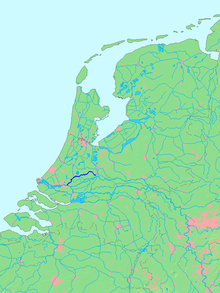 Location of Hollandse IJssel in dark blue. | |
| Location | |
| Country | Netherlands |
| State | South Holland, Utrecht |
| Physical characteristics | |
| Source | Merwede Canal |
| • location | Nieuwegein, Utrecht |
| • coordinates | 52°01′57″N 5°05′27″E |
| Mouth | Nieuwe Maas |
• location | Rotterdam, South Holland |
• coordinates | 51°54′29″N 4°33′40″E |
| Length | 46 km (29 mi) |
If the North Sea floods, the Hollandse IJssel allows water through the Rotterdam Waterway to flood low-lying land east of Rotterdam. The Delta Works included a steel barrier that can be lowered within minutes to block the waterway.[1] The sea protection constructions were built at the mouth of the Hollandse IJssel in 1957.
 |
 |
See also
Wikimedia Commons has media related to Hollandse IJssel. |
References
- Ley, Willy (October 1961). "The Home-Made Land". For Your Information. Galaxy Science Fiction. pp. 92–106.
This Utrecht location article is a stub. You can help Wikipedia by expanding it. |
This South Holland location article is a stub. You can help Wikipedia by expanding it. |
На других языках
[de] Hollandse IJssel
Die Hollandse IJssel (deutsch Holländische Issel) ist ein 46 Kilometer langer Fluss in den niederländischen Provinzen Utrecht und Südholland. Sie beginnt bei Nieuwegein neben dem Lek und fließt über Gouda nach Krimpen aan den IJssel, einem Vorort von Rotterdam. Dort mündet sie in die Nieuwe Maas. Die Hollandse IJssel ist unterhalb Gouda mit Schiffen bis 2000 t befahrbar. Durch sie strömen durchschnittlich 0,7 % des Rheinwassers.- [en] Hollandse IJssel
[it] Hollandse IJssel
Hollandse IJssel (detto anche Hollandsche IJssel, in italiano IJssel Olandese, per distinguerlo dall'IJssel della Gheldria) è un ramo del delta del Reno che scorre verso ovest da Nieuwegein sul fiume Lek attraverso IJsselstein, Gouda e Capelle aan den IJssel verso Krimpen aan den IJssel, dove termina nel Nieuwe Maas. Un altro ramo, chiamato Enge IJssel ("Ijssel Stretto"), scorre verso sud-ovest da Nieuwegein. Il nome IJssel si pensa derivi dal germanico i sala, che significa "acqua scura". In origine, l'Hollandse IJssel si biforcava dal fiume Lek a Nieuwegein, ma il collegamento fu interrotto con l'Hollandse IJssel che attualmente fornisce i pascoli circostanti.[ru] Холландсе-Эйссел
Холландсе-Эйссел (нидерл. Hollandse (Hollandsche[1]) IJssel) — рукав дельты Рейна в нидерландских провинциях Утрехт и Южная Голландия, который течёт по изогнутому руслу на запад от Ньивегейна до рукава Ньиве-Маас в пригородах Роттердама.Другой контент может иметь иную лицензию. Перед использованием материалов сайта WikiSort.org внимательно изучите правила лицензирования конкретных элементов наполнения сайта.
WikiSort.org - проект по пересортировке и дополнению контента Википедии