geo.wikisort.org - Island
Noord-Beveland (Dutch pronunciation: [ˈnoːrd ˌbeːvəlɑnt] (![]() listen); "North Beveland") is a municipality and region in the southwestern Netherlands and a former island, now part of the Walcheren-Zuid-Beveland-Noord-Beveland peninsula.
Noord-Beveland is enclosed by the Oosterschelde estuary to the north, and the former straits, now combined lake, of Veerse Meer and Zandkreek to the south. As part of the Delta Works, dams have connected Noord-Beveland to Walcheren and Zuid-Beveland.
listen); "North Beveland") is a municipality and region in the southwestern Netherlands and a former island, now part of the Walcheren-Zuid-Beveland-Noord-Beveland peninsula.
Noord-Beveland is enclosed by the Oosterschelde estuary to the north, and the former straits, now combined lake, of Veerse Meer and Zandkreek to the south. As part of the Delta Works, dams have connected Noord-Beveland to Walcheren and Zuid-Beveland.
Noord-Beveland
North Beveland | |
|---|---|
Municipality | |
 Aerial view of Noord-Beveland | |
 Flag Coat of arms | |
 Location in Zeeland | |
| Coordinates: 51°35′N 3°45′E | |
| Country | Netherlands |
| Province | Zeeland |
| Established | 1 January 1995 |
| Government | |
| • Body | Municipal council |
| • Mayor | Marcel Delhez (VVD) |
| Area | |
| • Total | 121.58 km2 (46.94 sq mi) |
| • Land | 85.96 km2 (33.19 sq mi) |
| • Water | 35.62 km2 (13.75 sq mi) |
| Elevation | 1 m (3 ft) |
| Population (January 2019)[4] | |
| • Total | 7,308 |
| • Density | 85/km2 (220/sq mi) |
| Demonym | Noord-Bevelander |
| Time zone | UTC+1 (CET) |
| • Summer (DST) | UTC+2 (CEST) |
| Postcode | 4484–4499 |
| Area code | 0113 |
| Website | www |
Population centers
- Colijnsplaat
- Geersdijk
- Kamperland
- Kats
- Kortgene
- Wissenkerke
There is no village called Noord-Beveland itself.
Topography

Dutch Topographic map of the municipality of Noord-Beveland, June 2015
Ganuenta
In Roman times, the town of Ganuenta lay north of where the village of Colijnsplaat is now, a location now covered by the water of the Oosterschelde. It was an important centre for trade. Nearby, there was a temple dedicated to the ancient regional sea goddess Nehalennia. A replica of this temple was officially opened in Colijnsplaat in August 2005.[5]
Notable people
- Johannis de Rijke (1842 in Colijnsplaat – 1913) a Dutch civil engineer and a foreign advisor to the Japanese government
- Eduard Flipse (1896 in Wissenkerke – 1973) a Dutch conductor and composer
- Neeltje Karelse (1926 in Kortgene – 2015) a Dutch track-and-field athlete, competed at 1948 Summer Olympics
Gallery
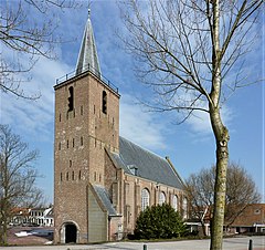 Nicolaaskerk, Kortgene
 Kamperland
 Molen De Korenbloem, Kortgene
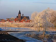 Vijver met kerk


References
- "Collegeleden" [Members of the board] (in Dutch). Gemeente Noord-Beveland. Archived from the original on 15 September 2012. Retrieved 12 December 2013.
- "Kerncijfers wijken en buurten 2020" [Key figures for neighbourhoods 2020]. StatLine (in Dutch). CBS. 24 July 2020. Retrieved 19 September 2020.
- "Postcodetool for 4491EV". Actueel Hoogtebestand Nederland (in Dutch). Het Waterschapshuis. Retrieved 12 December 2013.
- "Bevolkingsontwikkeling; regio per maand" [Population growth; regions per month]. CBS Statline (in Dutch). CBS. 1 January 2019. Retrieved 1 January 2019.
- Van der Velde, Koert (August 13, 2005). Zeeuwse godin weer thuis. Trouw (Dutch newspaper), p. 8–9.
External links
 Media related to Noord-Beveland at Wikimedia Commons
- Official website (in Dutch)
Places adjacent to Noord-Beveland | ||||||||||||||||
|---|---|---|---|---|---|---|---|---|---|---|---|---|---|---|---|---|
| ||||||||||||||||
Municipalities of Zeeland | ||
|---|---|---|
|  | |
| ||
На других языках
[de] Noord-Beveland
Noord-Beveland ( anhören?/i) ist eine Insel und zugleich eine Gemeinde in der niederländischen Provinz Zeeland. 1995 entstand die Gemeinde Noord-Beveland, als die bisherigen Gemeinden Kortgene und Wissenkerke zusammengeschlossen wurden.- [en] Noord-Beveland
[es] Noord-Beveland
Noord-Beveland es un municipio del suroeste de los Países Bajos y una antigua isla, parte de la península de Walcheren-Zuid-Beveland-Noord-Beveland. Noord-Beveland está encerrada por el estuario del Oosterschelde, al norte; y por los antiguos estrechos, hoy lagos combinados, de Veerse Meer y Zandkreek, al sur. Como una parte del Plan Delta, diques han conectado Noord-Beveland a Walcheren y Zuid-Beveland.[fr] Beveland-du-Nord
Beveland-du-Nord[1] (en néerlandais : Noord-Beveland) est une commune, anciennement une île et une région de polders de près de quatre cents ans et le cœur de la Zélande entourée par l'Escaut oriental, la mer du Nord et le Veerse Meer, L'île possède, à De Banjaard, la plus large plage de la mer du Nord. Beveland-du-Nord est la plus récente des îles zélandaises. Beveland-du-Nord est statistiquement la commune la plus ensoleillée des Pays-Bas.[ru] Норд-Бевеланд
Норд-Бевеланд (нидерл. и зеландск. Noord-Beveland) — остров и община в Нидерландах.Другой контент может иметь иную лицензию. Перед использованием материалов сайта WikiSort.org внимательно изучите правила лицензирования конкретных элементов наполнения сайта.
WikiSort.org - проект по пересортировке и дополнению контента Википедии