geo.wikisort.org - River
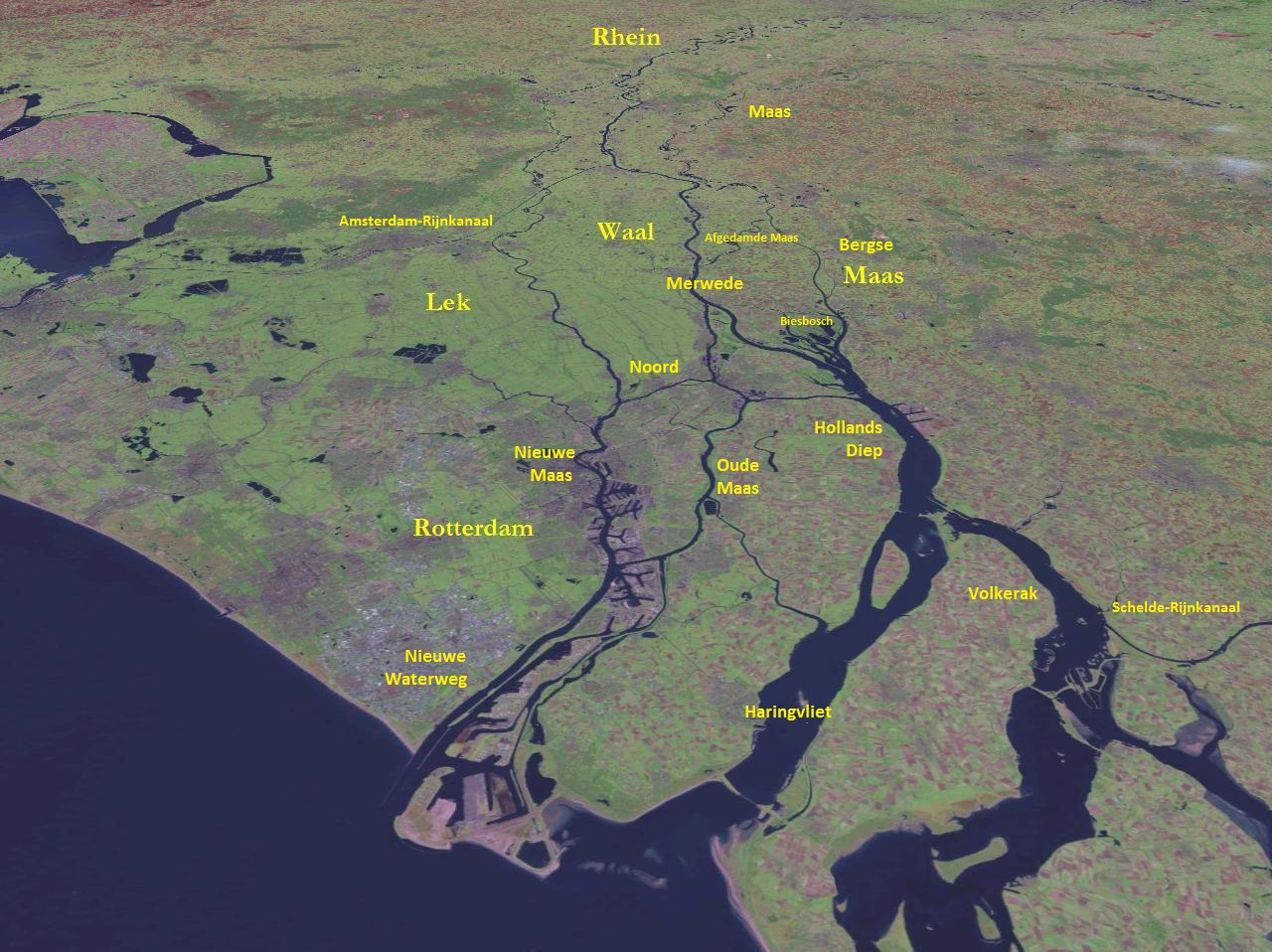
Hollands Diep (pre-1947 spelling: Hollandsch Diep) is a wide river in the Netherlands[2] and an estuary of the Rhine and Meuse rivers. Through the Scheldt-Rhine Canal it connects to the Scheldt river and Antwerp.
| Designations | |
|---|---|
Ramsar Wetland | |
| Designated | 29 August 2000 |
| Reference no. | 1273[1] |
The Bergse Maas river and the Nieuwe Merwede river join near Lage Zwaluwe to form the Hollands Diep. The Dordtsche Kil connects to it near Moerdijk. Near Numansdorp it splits into the Haringvliet and the Volkerak.
History
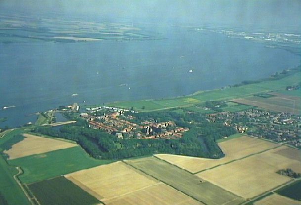
The Hollands Diep was formed as a result of the extensive flood of 1216, which breached the dunes of Voorne and created a deep saltwater inlet (the current Haringvliet). During a second flood, the St. Elizabeth floods, this inlet connected to the Merwede and became an important estuary of the Rhine and Meuse rivers. From that moment on, the freshwater part of the estuary (east of the Hellegatsplein) was renamed Hollands Diep. The former river Striene, that used to connect the Meuse with the Scheldt, was completely destroyed by these floods and can no longer be recognised on maps.
River crossings
At this point where the Hollands Diep splits, there is a road traffic node on an artificial island (the Hellegatsplein), connecting to the Hoeksche Waard island on the north by the Haringvliet bridge, to the Goeree-Overflakkee on the west by the Hellegatsdam, and to the mainland on the southeast by the Volkerak Sluices.
On the east side of the Hollands Diep the Moerdijk bridges connect the Dordrecht island on the north to the mainland on the south: a road bridge, a railroad bridge; a second railroad bridge has recently been constructed for the HSL-Zuid.
References
- "Hollands Diep". Ramsar Sites Information Service. Retrieved 25 April 2018.
- "Hollandsch Diep" (in Dutch). Rijkswaterstaat. Archived from the original on 2012-07-26.
На других языках
[de] Hollands Diep
Das in den Niederlanden gelegene Hollands Diep, auch Hollandsch Diep (deutsch Holländische Tiefe), ist der innerste, etwa 20 Kilometer lange Teil der stromartigen Nordsee-Bucht Haringvliet. An seinem östlichen Ende münden der südliche Hauptarm des Rheins (Waal, hier Nieuwe Merwede genannt) und die Maas (hier Bergsche Maas und am Ende Amer genannt). Die Nordsee erreichen diese gemeinsam, nach dem sie das insgesamt etwa 50 Kilometer lange Haringvliet durchflossen haben. Das Vliet ist seit 1970 gegen die See durch das Deltawerk Haringvlietdam absperrbar.- [en] Hollands Diep
[it] Hollandsch Diep
L'Hollandsch Diep (o Hollands Diep), è un grande ramo di fiume del delta del Reno, della Mosa e della Schelda nei Paesi Bassi, facente parte dell'itinerario fluviale principale tra Rotterdam e Anversa.[ru] Холландс-Дип
Хо́лландс-Ди́п (нидерл. Hollands(ch) Diep) — река в Нидерландах, эстуарий в дельте Рейна и Мааса. Канал Шельда-Рейн соединяет Холландс-Дип с портом Антверпена.Другой контент может иметь иную лицензию. Перед использованием материалов сайта WikiSort.org внимательно изучите правила лицензирования конкретных элементов наполнения сайта.
WikiSort.org - проект по пересортировке и дополнению контента Википедии