geo.wikisort.org - River
Nederrijn ("Lower Rhine"; not to be confused with the section called Lower Rhine further upstream) is the name of the Dutch part of the Rhine from the confluence at the town of Angeren of the cut-off Rhine bend of Oude Rijn (Gelderland) and the Pannerdens Kanaal (which was dug to form the new connection between the Waal and Nederrijn branches). The city of Arnhem lies on the right (north) bank of the Nederrijn, just past the point where the IJssel branches off. The Nederrijn flows on to the city of Wijk bij Duurstede, from where it continues as the Lek. The once-important but now small Kromme Rijn branch (in Roman times part of the Limes Germanicus and border river of the Roman Empire) carries the name "Rhine" towards the city of Utrecht.
This article does not cite any sources. (May 2012) |
| Nederrijn | |
|---|---|
 Nederrijn near Arnhem | |
 Location of the Nederrijn | |
| Location | |
| Country | Netherlands |
| Region | Gelderland |
| Physical characteristics | |
| Source | Pannerdens Kanaal |
| • location | Huissen, Gelderland, Netherlands 51°56′59″N 5°57′7″E |
| • coordinates | 51°56′59″N 5°57′7″E |
| Mouth | Lek |
• location | Wijk bij Duurstede, Utrecht, Netherlands 51°58′11″N 5°21′8″E |
• coordinates | 51°58′11″N 5°21′8″E |
| Length | 50 km (31 mi) |

From the city of Utrecht Kromme Rijn forks into the Vecht to the north, and into the Oude Rijn (Utrecht and South Holland) to the west. The first part is channelised and known as Leidse Rijn (Leiden Rhine), after the railway bridge near Harmelen (municipality Woerden) it's known as Oude Rijn, flowing westward to the North Sea.
In order to regulate the distribution of drainage between the different branches of the Rhine, several dams have been constructed. If the dams are closed, there is little flow in the Nederrijn and most of the water is drained by the IJssel. As for the Old Rhine, close to the North Sea a pumping station prevents the river for sea tides and silting.
Bridges over the Nederrijn are in Arnhem (railway and three road bridges), in Heteren (A50) and Rhenen. Ferries are found near Doorwerth, Wageningen, Opheusden, Elst and Amerongen.
History
In 1530, the Rhine near Arnhem was moved, a project that was completed in 1536. The city, which originated along the St. Jansbeek ("St. John's Brook'), could develop better now that it was closer to the river, and was also more easily defended against Habsburg expansionism into Guelders.
Gallery
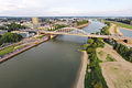 Nederrijn at Arnhem
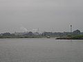 Nederrijn near Renkum
 Plate made by Wenzel Hollar 1607-1677
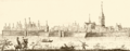 Wageningen 1730


 Panorama near Wageningen
 Nederrijn near Wageningen
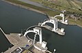 Weir near Amerongen
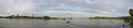
 The last stretch of the Nederrijn, near Wijk bij Duurstede


See also
- Lower Rhine
- Rhine delta
References
На других языках
[de] Nederrijn
Der Nederrijn ist der rechte der beiden großen Arme des Rheins in den Niederlanden. Der linke Arm ist die Waal, die aber erst im letzten Jahrtausend größere Mengen Rhein-Wasser ins heutige Rhein-Maas-Delta führt und zum Hauptabfluß des Rheins geworden ist. Der Nederrijn war der ursprüngliche, bei Katwijk in die Nordsee mündende Rhein. Heute fließt in seinem unteren Teil nach der Abzweigung des ins Rhein-Maas-Delta fließenden Lek kaum noch Wasser.- [en] Nederrijn
[it] Nederrijn
Il Nederrijn (in olandese Reno inferiore) è un ramo del Reno che attraversa i Paesi Bassi. Il suo corso parte come una continuazione del Canale di Pannerden, presso Angeren, poco prima della diramazione dell'IJssel, per poi dividersi presso Wijk bij Duurstede tra il fiume Lek e il corso d'acqua minore del Kromme Rijn.[ru] Недер-Рейн
Не́дер-Рейн[1][2] (нидерл. Nederrijn) — часть реки Рейн, рукав его дельты.Другой контент может иметь иную лицензию. Перед использованием материалов сайта WikiSort.org внимательно изучите правила лицензирования конкретных элементов наполнения сайта.
WikiSort.org - проект по пересортировке и дополнению контента Википедии