geo.wikisort.org - Mountains
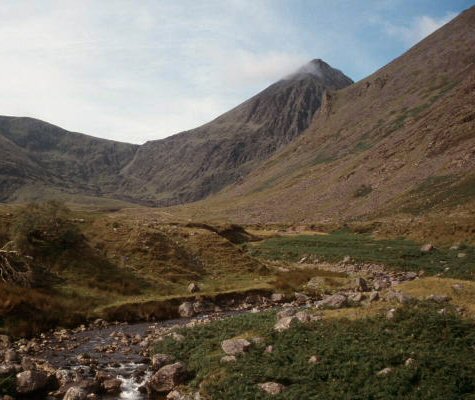
MacGillycuddy's Reeks (Irish: Na Cruacha Dubha, meaning 'the black stacks') is a sandstone and siltstone mountain range in the Iveragh Peninsula in County Kerry, Ireland. Stretching 19 kilometres (12 miles), from the Gap of Dunloe in the east, to Glencar in the west, the Reeks is Ireland's highest mountain range, and includes most of the highest peaks and sharpest ridges in Ireland, and the only peaks on the island over 1,000 metres (3,300 feet) in height.
| MacGillycuddy's Reeks | |
|---|---|
| Irish: Na Cruacha Dubha | |
 | |
| Highest point | |
| Peak | Carrauntoohil[1] |
| Elevation | 1,038.6[1] m (3,407 ft) |
| Coordinates | 52.01°N 9.70°W[1] |
| Dimensions | |
| Length | 19 km (12 mi) East–West |
| Naming | |
| English translation | the black stacks |
| Language of name | Irish |
| Geography | |
 MacGillycuddy's Reeks Location of the MacGillycuddy's Reeks | |
| Location | County Kerry |
| Country | Ireland |
| Provinces of Ireland | Munster |
| Topo map | OSI Discovery 78 |
| Geology | |
| Age of rock | Devonian[1] |
| Mountain type | Purple sandstone & siltstone[1] |
Near the centre of the range is Carrauntoohil, Ireland's highest mountain at 1,038.6 metres (3,407 ft). The range was heavily glaciated which carved out deep corries (e.g. the Eagle's Nest), U-shaped valleys (e.g. Lough Coomloughra), and sharp arêtes and ridges (e.g. the Beenkeragh Ridge).[2]
The range, part of the Reeks District, is a destination for mountain walkers and climbers and includes some of Ireland's most regarded walking routes such as the 15–kilometre Coomloughra Horseshoe, and the 26-kilometre MacGillycuddy's Reeks Ridge Walk that traverses the full range; it is estimated that over 140,000 people visit the range each year.[3] The entire range is in private ownership; however, reasonable access is given for recreational use.[2][3]
Geology
MacGillycuddy's Reeks are composed of sandstone particles of various sizes which are collectively known as the Old Red Sandstone. The rocks date from the Upper Devonian period (310–450 million years ago) when Ireland was in a hot equatorial setting.[2] During this 60 million year period, Ireland was the site of a major basin, known as the Munster basin, and the counties of Cork and Kerry were effectively a large alluvial floodplain.[2] Chemical oxidation stained the material with a purple–reddish colour (and green in places from chlorination), still visible today.[2] There are virtually no fossils in Old Red Sandstone.[2] The composition of Old Red Sandstone is variable and contains quartz stones, mudstones, siltstones, and sandstone particles (boulders of conglomerate rock containing quartz pebbles are visible throughout the range).[2] The Reeks were also subject to significant glaciation which led to fracturing of the rock, and resulted in deep corries (e.g. the Eagle's Nest), U-shaped valleys (e.g. Lough Coomloughra), and sharp arêtes and ridges (e.g. the Beenkeragh Ridge).[2][4]
Geography

MacGillycuddy's Reeks are variously described as consisting of two main sections, containing all ten of the Reeks that are above 3,000 ft:[5][2]
- Eastern Reeks, a high ridge connecting (west to east), Cnoc an Chuillinn, Maolán Buí, Cnoc na Péiste, The Big Gun, and Cruach Mhór; and
- Coomloughra Reeks, a horseshoe around Lough Coomloughra that connects, Caher (West Top), Caher, Carrauntoohil, The Bones, and Beenkeragh.
The Eastern Reeks meet the Coomloughea Reeks at the col of the Devil's Ladder, a popular ascent route for Carrauntoohil.[2]
MacGillycuddy's Reeks contains the three peaks in Ireland which are over 1,000 metres (3,300 feet) in height, namely: Carrauntoohil, Ireland's highest mountain at 1,038.6 m (3,407 ft), followed by Beenkeragh at 1,008 m (3,307 ft) and Caher at 1,000 m (3,300 ft).[6]
The range contains eleven of the fourteen peaks in Ireland that are over 3,000 ft (910 m) in height, and meet the Vandeleur-Lynam classification of a mountain—peaks with a prominence over 15 m (49 ft).[7] All but one of these eleven 3,000 ft peaks, namely Cnoc an Chuillinn East Top, are amongst the list of thirteen Irish Furths—peaks which meet the Scottish Mountaineering Club's criteria for a Munro, and they are therefore also known as Irish Munros.[8]
There are 29 peaks in the range above 100 m (330 ft) in height.[6] The range contains 14 Irish Hewitts (height above 2,000 ft and prominence above 30 metres),[9][6] and 16 Irish Arderins (height above 500 metres and prominence above 30 metres).[10] The range is also known for its sharp aretes, including The Bones arete, more famously known as the Beenkeragh Ridge, and The Big Gun arete.[6]
A feature of the range is the modest topographic prominence, or "drop" between many of its peaks.[9][5] Only two of the eleven Reeks over 3,000 ft meet the Marilyn classification of a mountain (a prominence above 150 metres), namely Carrauntoohil and Cnoc na Péiste.[9] The only Reek that meets the P600 classification (a prominence above 600 metres), is Carrauntoohil itself.[9] The combination of high peaks and low prominence, means the ridges between the peaks are at a sustained height (e.g. why the prominence is so modest), which has contributed to the popularity of ridge walking in the Reeks, particularly, the Coomloughra Horseshoe, and the MacGillycuddy's Reeks Ridge Walk, and the term, "Ireland's highest mountain range".[5][6]
Ownership
The entire range is held in private ownership, both in individually owned freehold parcels in the lower reaches and in commonly owned, open upland zones (‘commonage’). A State-sponsored report into access for the range in December 2013 titled MacGillycuddy Reeks Mountain Access Development Assessment (also called the Mountain Access Project, or MAP), mapped the complex network of land titles.[4] Unlike many other national mountain ranges, the MacGillycuddy's Reeks are not part of a national park or a trust structure.[4][3]
The private ownership has led to issues around the upkeep of popular paths in the Reeks, most particularly the erosion of the Devil's Ladder path, which is used to summit Carrauntoohil; and various car-parks and bridges used by climbers.[11][4] The 2013 MAP report noted the importance of safety in light of the increasing climbers and walkers to the Reeks. The MAP report stated that Kerry Mountain Rescue ("KMR") logged 17 fatalities on the Reeks between 1966 and 2000, or about one every second year, but since 2000, KMR had been logging approximately 2 fatalities per annum.[2][3]
In 2019 the Irish Times reported that the MacGillycuddy Reeks Mountain Access Forum, a cross-body group of landowners, commercial users and public access and walking groups set up in 2014 with the aim of "protecting, managing and sustainably developing the MacGillycuddy's Reeks mountain range, while halting and reversing the obvious and worsening path erosion", had achieved some success laying down new pathways in the Hag's Glen approach to Carrauntoohil; however, the Irish Times still wondered, "Should the Kerry reeks be a national park?".[3]
Naming

The name of the range is Irish: Cruacha Dubha Mhic Giolla Mo Chuda, which is shortened in the Irish form to Irish: Na Cruacha Dubha, meaning "The Black Stacks".[12][13] However, in the English form, the name is translated as "MacGillycuddy's Reeks" (the translation used in Gasaitéar na hÉireann).[13] The English name is sometimes incorrectly written as "The MacGillycuddy's Reeks", "MacGillycuddy Reeks", or "Macgillycuddy's Reeks".[13][14]
The MacGillycuddy (Irish: Mhic Giolla Mo Chuda) were a sept, or branch, of the O'Sullivan Moore clan. The MacGillycuddy is recorded as being one of a smaller number of Gaelic chieftains whose lands were returned post the Cromwellian confiscations, which explains why the name survives to this day.[13] The MacGillycuddy family tomb is at Kilgobnet (Kerry), between the mountains and Killorglin.[13] The clan chief, McGillycuddy of the Reeks, owned land in this part of Munster until the end of the 20th century. The word reek is a Hiberno-English version of the English word rick, meaning a stack.[14]
Recreation
Visitors
Jim Ryan's 2006 book on the Reeks, Carrauntoohil and MacGillycuddy's Reeks: A Walking Guide to Ireland's Highest Mountains, stated that there were 25,000 annual visitors to the Reeks.[2] The 2013 MAP report quoted Ryan's figures, which were cited in the MAP's Terms of Reference, but stated that: "The Reeks are accessed by at least 25,000 recreational users per annum. It is highly likely that the numbers are a factor of 4 times higher based on observation of the year-round level of usage – but data is required to ascertain the visitor numbers."[4] It was estimated that 125,000 visitors entered the range in 2017 from footfall at three main access points,[11] and that 140,000 entered in 2018 by recording footfall at four main access points.[3]
Hill walking

The most common reason for visiting the Reeks is to climb Ireland's highest mountain, Carrauntoohil. The popular route starts from Cronin's Yard (V837873) and enters the Hag's Glen to climb the Devil's Ladder (the col between Carrauntoohil and Cnoc na Toinne), from which the summit is accessed.[5] A more challenging route is via the Hag's Tooth Ridge which circles the Eagle's Nest, and takes in Beenkeragh, and the Beenkeragh Ridge.[2]
MacGillycuddy's Reeks is particularly regarded for the quality of its ridge walking routes,[5] with the 6–8 hour 15 kilometres (9.3 mi) Coomloughra Horseshoe, that circles Lough Coomloughra, considered "one of Ireland's classic ridge walks", which takes in all three of Ireland's 1,000 metres (3,300 ft) peaks, namely, Carrauntoohil, Beenkeragh, and Caher (East Top and West Top), as well as the famous Beenkeragh Ridge.[15][16][5][2]
The most challenging route is the full MacGillycuddy's Reeks Ridge Walk, a 12- to 14-hour, 26-kilometre (16 mi) traverse of the entire range.[2] The route normally starts at the eastern end from Kate Kearney's Cottage in the Gap of Dunloe.[17] The route takes in Stickeen Mountain (440 metres (1,440 ft)) and Cnoc an Bhráca (731 metres (2,398 ft)) before reaching the ridge proper at Cruach Mhór (932 metres (3,058 ft)). From there it continues along the narrow arete of The Big Gun (939 metres (3,081 ft)) to Cnoc na Péiste (988 metres (3,241 ft)), and continuing along the chain of Maolán Buí (923 metres (3,028 ft)), Cnoc an Chuillinn (958 metres (3,143 ft)), Cnoc na Toinne (845 metres (2,772 ft)) to the summit of Carrauntoohil (1,038 metres (3,406 ft)).
From Carrauntoohil, a number of variations are possible, the main one being a detour to Beenkeragh (1,008 metres (3,307 ft)) before returning along the same route to get to Caher (1,000 metres (3,300 ft)) and then on to Caher West Top (975 metres (3,199 ft)) before descending to the Hydro-Track (V772871) car park near Lough Acoose, Glencar.
An alternative variation is to continue from Beenkeragh on the northern side of the Coomloughra Horseshoe to the peaks or Skregmore (848 metres (2,782 ft)) and Cnoc Íochtair (747 metres (2,451 ft)) before descending to the Hydro-Track car park.[18][5][2]
Rock and winter climbing

MacGillycuddy's Reeks are not especially known for their rock-climbing routes, unlike Ailladie in Clare or Fair Head in Antrim. The 450 metres (1,480 ft) rock climbing grade Very Difficult (V-Diff), Howling Ridge up the central arete between the east and north-east faces of Carrauntoohil is notable.[19][20][21] The north-east face of Carrauntoohil (e.g. the Eagle's Nest area), is better known for its winter climbing, conditions permitting, offering 80 routes with 7 up to winter Grade V.[22][23]
List of peaks
The following is a download from the MountainViews Online Database, which lists 29 identifiable Reeks with an elevation, or height, above 100 metres (330 ft).[24]
| Height Rank |
Prominence Rank |
Name | Height (m) |
Prominence (m) |
Height (ft) |
Prominence (ft) |
Topo Map |
OSI Grid Reference |
|---|---|---|---|---|---|---|---|---|
| 1 | 1 | Carrauntoohil | 1,039 | 1,039 | 3,407 | 3,407 | 78 | V804844 |
| 2 | 8 | Beenkeragh | 1,008 | 91 | 3,308 | 298 | 78 | V801852 |
| 3 | 5 | Caher | 1,000 | 100 | 3,281 | 327 | 78 | V793839 |
| 4 | 2 | Cnoc na Péiste | 988 | 253 | 3,241 | 830 | 78 | V836842 |
| 5 | 25 | Caher West Top | 973 | 24 | 3,194 | 79 | 78 | V790840 |
| 6 | 20 | Maolán Buí | 973 | 38 | 3,192 | 125 | 78 | V832838 |
| 7 | 15 | Cnoc an Chuillinn | 958 | 53 | 3,143 | 174 | 78 | V823833 |
| 8 | 21 | The Bones | 957 | 37 | 3,138 | 122 | 78 | V801847 |
| 9 | 12 | The Big Gun | 939 | 74 | 3,081 | 243 | 78 | V840845 |
| 10 | 22 | Cruach Mhór | 932 | 34 | 3,058 | 112 | 78 | V841848 |
| 11 | 28 | Cnoc an Chuillinn East Top | 926 | 21 | 3,038 | 69 | 78 | V828834 |
| 12 | 23 | Knockbrinnea (W) | 854 | 29 | 2,802 | 95 | 78 | V807858 |
| 13 | 26 | Stumpa Bharr na hAbhann | 852 | 23 | 2,796 | 76 | 78 | V797858 |
| 14 | 16 | Skregmore | 848 | 50 | 2,781 | 164 | 78 | V792860 |
| 15 | 27 | Knockbrinnea (E) | 847 | 22 | 2,779 | 72 | 78 | V810857 |
| 16 | 9 | Cnoc na Toinne | 845 | 80 | 2,772 | 262 | 78 | V811833 |
| 17 | 19 | Cnoc Íochtair | 746 | 44 | 2,448 | 144 | 78 | V785860 |
| 18 | 7 | Cnoc an Bhráca | 731 | 96 | 2,398 | 315 | 78 | V858854 |
| 19 | 14 | Cnoc na dTarbh | 655 | 60 | 2,149 | 197 | 78 | V862850 |
| 20 | 29 | Hag's Tooth | 650 | 15 | 2,133 | 49 | 78 | V809850 |
| 21 | 17 | Brassel Mountain | 575 | 50 | 1,886 | 164 | 78 | V830823 |
| 22 | 10 | Screig Bheag | 573 | 78 | 1,880 | 256 | 78 | V787874 |
| 23 | 6 | Binn Bhán | 460 | 96 | 1,508 | 315 | 78 | V756828 |
| 24 | 24 | Binn Dubh | 452 | 27 | 1,483 | 89 | 78 | V749829 |
| 25 | 11 | Binn Dhearg | 450 | 76 | 1,475 | 249 | 78 | V762820 |
| 26 | 18 | Struicín | 440 | 45 | 1,444 | 148 | 78 | V866882 |
| 27 | 13 | Cnoc Breac | 425 | 70 | 1,394 | 230 | 78 | V757868 |
| 28 | 3 | Knocknabrone Hill | 353 | 188 | 1,158 | 617 | 78 | V801881 |
| 29 | 4 | Gortnagan | 298 | 122 | 978 | 400 | 78 | V721885 |
See also
- Lists of mountains in Ireland
- List of Irish counties by highest point
- List of mountains of the British Isles by height
- List of P600 mountains in the British Isles
- List of Furth mountains in the British Isles
- List of highest points of European countries
- List of countries by highest point
References
- MountainViews: Carrauntoohil
- Ryan, Jim (2006). "Chapter One: MacGillycuddy's Reeks - A Profile". Carrauntoohil and MacGillycuddy's Reeks: A Walking Guide to Ireland's Highest Mountains. Collins Press. ISBN 978-1905172337.
- John G O'Dwyer (22 June 2020). "Should the Kerry reeks be a national park?". Irish Times. Retrieved 25 March 2020.
In 2018, 140,000 recreation seekers entered on to the area from the four main access points.
- "MacGillycuddy Reeks Mountain Access Development Assessment" (PDF). South Kerry Development Partnership. December 2013.
- Dillion, Paddy (1993). "Chapter 41, Chapter 42". The Mountains of Ireland: A Guide to Walking the Summits. Cicerone. ISBN 978-1852841102.
- MountainViews (Simon Stewart) (2013). A Guide to Ireland's Mountain Summits: The Vandeleur-Lynams & the Arderins. Collins Books. pp. 85–95, 120–145. ISBN 978-1-84889-164-7.
- "Vandeleur-Lynams: Irish mountains of 600+m with a prominence of 15m". MountainViews Online Database. October 2018.
- "Hill Lists: Furths". Scottish Mountaineering Club.
The list of peaks of 3000ft or more within the United Kingdom and the Republic of Ireland outside (furth) of Scotland. There are currently 34 Furths.
- Chris Cocker; Graham Jackson (2018). "The Database of British and Irish Hills". Database of British and Irish Hills.
- "Arderins: Irish mountains of 500+m with a prominence of 30m". MountainViews Online Database. October 2018.
- "Managing visitor impact on The MacGillycuddy's Reeks is still quite a hill to climb". Irish Examiner. 12 November 2018. Retrieved 25 March 2020.
The attraction of being Ireland's highest mountain range draws a horde of visitors year-round, with 125,000 recreation seekers entering on to the Reeks from the three main access points during 2017.
- Paul Tempan (2006). "Irish mountain names and their international links". MountainViews Online Database.
Cruach - ‘stack, rick, pile’: Given the original meaning of this word, it is not surprising that most of the mountains with names in cruach show a symmetrical triangular profile, rather like a haystack. This is very evident in the case of na Cruacha Dubha (MacGillycuddy's Reeks) or, to give them their full and rather poetic title, Cruacha Dubha Mhic Giolla Mochuda.
- Paul Tempan (2006). "REVIEW: Jim Ryan - Carrauntoohil & MacGillycuddy's Reeks: A Walking Guide to Ireland's Highest Mountains". MountainViews Online Database.
However, he makes no mention here, or elsewhere in the book, of the MacGillycuddys (a branch of O'Sullivan More), the family most intimately connected with the Reeks, as well as the area to the north, and which gave its name to the range (Cruacha Dubha Mhic Giolla Mo Chuda, usually shortened to just Na Cruacha Dubha, 'the black stacks'). The MacGillycuddy was one of the few Gaelic chieftains to have his lands restored after the Cromwellian confiscations, a circumstance which helps to explain why the name has survived to this day. The MacGillycuddy family tomb is at Kilgobnet, between the mountains and Killorglin.
- Paul Tempan (February 2012). "Irish Hill and Mountain Names" (PDF). MountainViews.ie. pp. 59, 69.
- John O'Dwyer (20 June 2009). "Our Nation's Finest Mountain Route". Irish Times.
There are a few candidates for this honour; Dingle's Brandon Ridge, Connemara's Glencoaghan Horseshoe and Mayo's Mweelrea Circuit immediately spring to mind. But nearly all hillwalkers now agree that one route stands out above even such splendour. Kerry's Coomloughra Horseshoe is virtually impossible to match in an Irish context, as it takes in our three highest summits and offers an adrenalin-filled crossing of a memorable mountain ridge, great long-range coastal views and a birds-eye panorama over some of Killarney's renowned lakes and fells.
- "Route Descriptions". Kerry Mountain Rescue Teams. 2018.
- Con Moriarty (2018). "The Ridge of the Reeks". Hidden Ireland Tours.
Simply, the finest mountain traverse in Ireland with 7 summits over 3000 ft. From Kate Kearney's Cottage, in the Gap of Dunloe, to Doire na Féinne and Loch a’ Chúis
- "MacGillycuddy's Reeks and Carrauntoohil, Entire Mountain Range Walk". activeme.ie. 2017.
- David Flanagan (November 2014). "Section 10: Carrauntoohil (Howling Ridge)". Rock Climbing In Ireland. ISBN 978-0956787422.
- "Howling Ridge". KerryClimbing. 2017.
- "Watch the incredible Howling Ridge climb on Ireland's highest peak". Irish Independent. 23 March 2018.
- "Carrauntoohil Winter Climbs". UKClimbing.com. 12 August 2018.
- "Rock and Winder Guide: Carrauntoohil". KerryClimbing.ie. 2017.
- "MacGillycuddy's Reeks". MountainViews Online Database. Retrieved 10 April 2020.
Further reading
- Dillion, Paddy (1993). The Mountains of Ireland: A Guide to Walking the Summits. Cicerone. ISBN 978-1852841102.
- Fairbairn, Helen (2014). Ireland's Best Walks: A Walking Guide. Collins Press. ISBN 978-1848892118.
- Kelly, Piaras (2016). MacGillycuddy's Reeks – Winter Climbs. Piaras Kelly. ISBN 978-1-5262-0666-4.
- O'Sullivan, Valerie (2017). The MacGillycuddy's Reeks: People and Places of Ireland's Highest Mountain Range. Collins Press. ISBN 978-1848892941.
- Ryan, Jim (2006). Carrauntoohil and MacGillycuddy's Reeks: A Walking Guide to Ireland's Highest Mountains. Collins Press. ISBN 978-1905172337.
- Stewart, Simon (2013). A Guide to Ireland's Mountain Summits: The Vandeleur-Lynams & the Arderins. Collins Books. ISBN 978-1-84889-164-7.
External links
- MountainViews: The Irish Mountain Website
- Hill Bagging UK & Ireland, the searchable interface for the DoBIH
- Winter Climbing around Carrauntoohil, The Irish Climbing Wiki
- Ordnance Survey Ireland ("OSI") Online Map Viewer
- MacGillycuddy's Reeks Mountain Access Forum, group tasked with developing the range
- Hag's Glen, MacGillycuddy's Reeks, aerial photograph of the central Reeks.
| British Isles |  | |
|---|---|---|
| Scotland | ||
| Outside Scotland | ||
| England | ||
| Ireland | ||
| County tops |
| |
Highest mountains of Ireland (by province) | ||
|---|---|---|
| Munster |
|  |
| Leinster |
| |
| Ulster |
| |
| Connacht |
| |
List of mountains in Ireland | ||
Mountains and hills of Munster | |||||||
|---|---|---|---|---|---|---|---|
| Ballyhoura Mountains |  | ||||||
| Boggeragh Mountains | |||||||
| Caha Mountains | |||||||
| Comeragh Mountains | |||||||
| Derrynasaggart Mountains | |||||||
| Dingle Peninsula |
| ||||||
| Galty Mountains | |||||||
| Iveragh Peninsula | |||||||
| Knockmealdown Mountains | |||||||
| MacGillycuddy's Reeks |
| ||||||
| Mangerton Mountains | |||||||
| Shehy Mountains | |||||||
| Silvermine Mountains | |||||||
| Slieve Miskish Mountains | |||||||
| Others |
| ||||||
Authority control | |
|---|---|
| General |
|
| National libraries | |
На других языках
[de] Macgillycuddy’s Reeks
Macgillycuddy’s Reeks (irisch: Na Cruacha Dubha) ist die Bezeichnung für einen Gebirgszug in Irland. Der Carrantuohill ist sowohl höchster Berg der Macgillycuddy's Reeks als auch der gesamten Insel (1041 m). Auch die anderen beiden Gipfel Irlands über der Tausend-Meter-Grenze befinden sich hier, der Beenkeragh (irisch Binn Chaorach; 1010 m) und der 1001 m hohe Caher (irisch Cathair); insgesamt besteht der Gebirgszug aus über 100 Gipfeln. Die Berge stellen einen Teil der Armorischen Highlands dar und bestehen aus von Gletschern geformten Sandsteinmassiven.- [en] MacGillycuddy's Reeks
[es] Macgillicuddy's Reeks
MacGillycuddy's Reeks (irlandés:Na Cruacha Dubha, que significa "Las pilas negras") es una cordillera en el condado de Kerry, Irlanda.[fr] Macgillycuddy's Reeks
Les MacGillycuddy's Reeks (en irlandais Na Cruacha Dubha, littéralement « les sommets noirs ») est une chaîne de montagne située dans le comté de Kerry dans le sud-ouest de l'Irlande. La chaîne se trouve dans la péninsule d'Iveragh au sud-ouest de Killarney.[it] Macgillycuddy's Reeks
Macgillycuddy's Reeks (in gaelico irlandese Na Cruacha Dubha, che significa " I camini neri"), è una catena montuosa irlandese, situata nella contea di Kerry, a sua volta collocata nella provincia di Munster.[ru] Макгилликаддис-Рикс
Макгилликаддис-Рикс (англ. Macgillycuddy's Reeks, ирл. Na Cruacha Dubha) — горы на юго-западе Ирландии (территория графства Керри). Длина хребта — около 19 км.Другой контент может иметь иную лицензию. Перед использованием материалов сайта WikiSort.org внимательно изучите правила лицензирования конкретных элементов наполнения сайта.
WikiSort.org - проект по пересортировке и дополнению контента Википедии