geo.wikisort.org - Mountains
Eagle's Nest (Chinese: 鷹巢山), also known indigenously as Tsim Shan (尖山), is a hill north of Cheung Sha Wan of Hong Kong. The hill peaks at 305 metres and is within Sha Tin District with border to Sham Shui Po District at her south. The hill is located northeast of Piper's Hill and northwest of Crow's Nest. Eagle's Nest Nature Trail goes around her peak while the Stage 5 of MacLehose Trail runs on her north.[1][2]
| Eagle's Nest, Hong Kong | |
|---|---|
| 尖山 | |
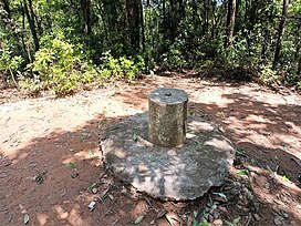
 Trigonometrical station at the summit of Eagle's Nest | |
| Highest point | |
| Elevation | 305 m (1,001 ft) |
| Coordinates | 22°20′47.29″N 114°9′37.43″E |
| Geography | |
 Eagle's Nest, Hong Kong Location of Eagle's Nest in Hong Kong | |
| Location | |
Transport

The hill is the site of Eagle's Nest Tunnel, a major infrastructure project in the area.
References
- Tang, Timothy. "Traffic Statistics - Eagle's Nest Tunnel and Sha Tin Heights Tunnel". Hong Kong Transport Department. Retrieved 9 January 2019.
- "Sha Tin Pass Road to Kowloon Reservoir | Hong Kong Tourism Board". www.discoverhongkong.com. Retrieved 2020-04-05.
See also
- List of mountains, peaks and hills in Hong Kong
- Sha Tin Heights
Текст в блоке "Читать" взят с сайта "Википедия" и доступен по лицензии Creative Commons Attribution-ShareAlike; в отдельных случаях могут действовать дополнительные условия.
Другой контент может иметь иную лицензию. Перед использованием материалов сайта WikiSort.org внимательно изучите правила лицензирования конкретных элементов наполнения сайта.
Другой контент может иметь иную лицензию. Перед использованием материалов сайта WikiSort.org внимательно изучите правила лицензирования конкретных элементов наполнения сайта.
2019-2025
WikiSort.org - проект по пересортировке и дополнению контента Википедии
WikiSort.org - проект по пересортировке и дополнению контента Википедии