geo.wikisort.org - Mountains
Croghan Mountain or Croghan Kinsella (Irish: Cruachán Uí Chinnsealaigh, meaning 'little stack of the Kinsella family')[2] at 606 metres (1,988 ft), is the 211th–highest peak in Ireland on the Arderin scale,[3] and the 258th–highest peak on the Vandeleur-Lynam scale.[4][5] Croghan is situated at the far southeastern end of the Wicklow Mountains on the Wicklow and Wexford border, in Ireland.[5]
| Croghan Mountain | |
|---|---|
| Cruachán Uí Chinnsealaigh | |
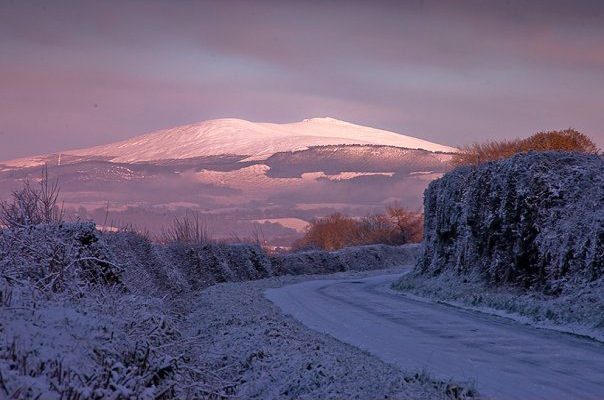 Croghan, and Croghan East Top, in snow as viewed from Kilcavan, County Wicklow | |
| Highest point | |
| Elevation | 606 m (1,988 ft)[1] |
| Prominence | 541 m (1,775 ft)[1] |
| Listing | Hewitt, Marilyn, Arderin, Simm, Vandeleur-Lynam |
| Coordinates | 52°48′N 6°19′W |
| Naming | |
| English translation | little stack of Kinsella |
| Language of name | Irish |
| Geography | |
 Croghan Mountain Location in Ireland | |
| Location | Wicklow/Wexford border, Ireland |
| Parent range | Wicklow Mountains |
| OSI/OSNI grid | T1309672884 |
| Topo map | OSi Discovery 62 |
| Geology | |
| Type of rock | Basalt and gabbro[1] |
Naming
The fuller name comes from the Uí Chinnsealaigh, who were the dominant gaelic family in the area; and is used to differentiate it from other "Cruachan" mountains.[2][6]
Geography
Croghan is situated at the far southeastern end of the Wicklow Mountains on the Wicklow and Wexford border, in Ireland.[5] Croghan is separated from the main range on its own small massif that includes neighbouring Croghan East Top 562 metres (1,844 ft) (which gives Croghan the profile of a "double peak"), and Slievefoore 414 metres (1,358 ft) to the east. Croghan is the source of the River Bann with rises from its southern slopes.[5]
Raheenleagh Wind Farm
The eastern side of Croghan contains the Raheenleagh Wind Farm, which was a 32.2 MW Coillte-ESB Group joint venture project that opened on 20 September 2016.[7] The wind farm was constructed in an existing Coillte forest, and consists of 11 Siemens Wind Power (108 – DD – 3.2MW) wind turbines.[7] The project received planning permission in 2012, and a 17-month construction process started in mid-2015.[7]
In 2018, it was reported that Coillte had sold their 50 percent stake to Greencoat Renewables.[8]
Bibliography
- MountainViews Online Database (Simon Stewart) (2013). A Guide to Ireland's Mountain Summits: The Vandeleur-Lynams & the Arderins. Collins Books. ISBN 978-1-84889-164-7.
See also
- Wicklow Way
- Wicklow Mountains
- Lists of mountains in Ireland
- List of mountains of the British Isles by height
- List of Marilyns in the British Isles
- List of Hewitt mountains in England, Wales and Ireland
References
- "Croghan Mountain/Croghan Kinsella". MountainViews Online Database. Retrieved 15 July 2019.
- Paul Tempan (February 2012). "Irish Hill and Mountain Names" (PDF). MountainViews.ie.
- Simon Stewart (October 2018). "Arderins: Irish mountains of 500+m with a prominence of 30m". MountainViews Online Database.
- Simon Stewart (October 2018). "Vandeleur-Lynams: Irish mountains of 600+m with a prominence of 15m". MountainViews Online Database.
- Mountainviews, (September 2013), "A Guide to Ireland's Mountain Summits: The Vandeleur-Lynams & the Arderins", Collins Books, Cork, ISBN 978-1-84889-164-7
- Brendan Bracken (6 March 2010). "Go Walk: Raheenleagh Wood to Croghan Mountain, Co Wexford/Co Wicklow". Irish Times. Retrieved 25 July 2019.
- "About the Raheenleagh Wind Farm Project". Raheenleagh Wind Farm. Retrieved 25 July 2019.
- Joe Brennan (11 September 2018). "State to share in €136m Coillte will earn from sale of its stake in four wind farms". Irish Times. Retrieved 25 July 2019.
External links
- MountainViews: The Irish Mountain Website, Croghan (or Croghan Kinsella)
- MountainViews: Irish Online Mountain Database
- The Database of British and Irish Hills , the largest database of British Isles mountains ("DoBIH")
- Hill Bagging UK & Ireland, the searchable interface for the DoBIH
| British Isles |  | |
|---|---|---|
| Scotland | ||
| Outside Scotland | ||
| England | ||
| Ireland | ||
| County tops | ||

Lists of long-distance trails in Ireland | ||||||
|---|---|---|---|---|---|---|
| Long-Distance |
|   | ||||
| Pilgrim path |
| |||||
| Cycle greenway |
| |||||
| Boarded mountain | ||||||
| Fell running | ||||||
This article related to the geography of County Wicklow, Ireland is a stub. You can help Wikipedia by expanding it. |
На других языках
- [en] Croghan Mountain
[fr] Croghan Kinsella
Croghan Kinsella ou Croghan Mountain (en irlandais : Cruachán Uí Chinnsealaigh, littéralement « petit tas de la famille Kinsella ») est un sommet des montagnes de Wicklow culminant à 606 mètres d'altitude, en Irlande. Le bassin de la rivière Bann naît sur ses pentes.Другой контент может иметь иную лицензию. Перед использованием материалов сайта WikiSort.org внимательно изучите правила лицензирования конкретных элементов наполнения сайта.
WikiSort.org - проект по пересортировке и дополнению контента Википедии